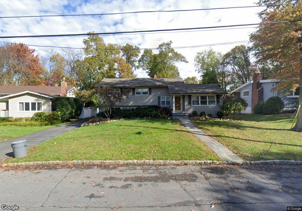
10 Karen Way Summit, NJ 07901
Estimated Value: $996,489 - $1,630,000
Studio
--
Bath
2,012
Sq Ft
$662/Sq Ft
Est. Value
About This Home
This home is located at 10 Karen Way, Summit, NJ 07901 and is currently estimated at $1,332,622, approximately $662 per square foot. 10 Karen Way is a home located in Union County with nearby schools including L C Johnson Summit Middle School, Summit Sr High School, and Kent Place School.
Ownership History
Date
Name
Owned For
Owner Type
Purchase Details
Closed on
Oct 11, 2002
Sold by
Bicca Antonio
Bought by
Vilar Regina
Current Estimated Value
Home Financials for this Owner
Home Financials are based on the most recent Mortgage that was taken out on this home.
Original Mortgage
$380,000
Outstanding Balance
$158,263
Interest Rate
6.07%
Estimated Equity
$1,174,359
Purchase Details
Closed on
Mar 15, 2002
Sold by
Garlen Hyla B
Bought by
Bicca Antonio
Home Financials for this Owner
Home Financials are based on the most recent Mortgage that was taken out on this home.
Original Mortgage
$340,000
Interest Rate
10.1%
Create a Home Valuation Report for This Property
The Home Valuation Report is an in-depth analysis detailing your home's value as well as a comparison with similar homes in the area
Home Values in the Area
Average Home Value in this Area
Purchase History
We collect this data history from publicly available records. To have your information removed, we recommend requesting removal directly through your county’s website.
| Date | Buyer | Sale Price | Title Company |
|---|---|---|---|
| Vilar Regina | $475,000 | -- | |
| Bicca Antonio | $425,000 | First American Title Ins Co |
Source: Public Records
Mortgage History
We collect this data history from publicly available records. To have your information removed, we recommend requesting removal directly through your county’s website.
| Date | Status | Borrower | Loan Amount |
|---|---|---|---|
| Open | Vilar Regina | $380,000 | |
| Previous Owner | Bicca Antonio | $340,000 |
Source: Public Records
Tax History
| Year | Tax Paid | Tax Assessment Tax Assessment Total Assessment is a certain percentage of the fair market value that is determined by local assessors to be the total taxable value of land and additions on the property. | Land | Improvement |
|---|---|---|---|---|
| 2025 | $11,225 | $257,700 | $140,500 | $117,200 |
| 2024 | $11,151 | $257,700 | $140,500 | $117,200 |
| 2023 | $11,151 | $257,700 | $140,500 | $117,200 |
| 2022 | $11,125 | $257,700 | $140,500 | $117,200 |
| 2021 | $11,125 | $257,700 | $140,500 | $117,200 |
| 2020 | $11,236 | $257,700 | $140,500 | $117,200 |
| 2019 | $11,249 | $257,700 | $140,500 | $117,200 |
| 2018 | $11,176 | $257,700 | $140,500 | $117,200 |
| 2017 | $11,249 | $257,700 | $140,500 | $117,200 |
| 2016 | $11,084 | $257,700 | $140,500 | $117,200 |
| 2015 | $10,867 | $257,700 | $140,500 | $117,200 |
| 2014 | $10,586 | $257,700 | $140,500 | $117,200 |
Source: Public Records
Map
Nearby Homes
- 128 Canoe Brook Pkwy
- 275 Woodland Ave
- 44 Canoe Brook Pkwy
- 11 Lewis Ave
- 115 Woodland Ave
- 27 Bedford Rd
- 25 Bedford Rd
- 230 Summit Ave
- 49 Norwood Ave
- 76 Woodland Ave
- 81 Summit Ave
- 18 University Ave
- 149 Hillcrest Ave
- 20 Edgar St
- 60 Fernwood Rd
- 55 Oxbow Ln
- 77 Kent Place Blvd
- 107 Kent Place Blvd
- 23 Euclid Ave
- 20 N Summit Ave
- 14 Karen Way
- 8 Karen Way
- 16 Karen Way
- 230 Woodland Ave
- 232 Woodland Ave
- 6 Karen Way
- 9 Karen Way
- 226 Woodland Ave
- 11 Karen Way
- 234 Woodland Ave
- 20 Karen Way
- 90 Canoe Brook Pkwy
- 88 Canoe Brook Pkwy
- 224 Woodland Ave
- 15 Karen Way
- 92 Canoe Brook Pkwy
- 238 Woodland Ave
- 86 Canoe Brook Pkwy
- 19 Karen Way
- 22 Karen Way
Your Personal Tour Guide
Ask me questions while you tour the home.