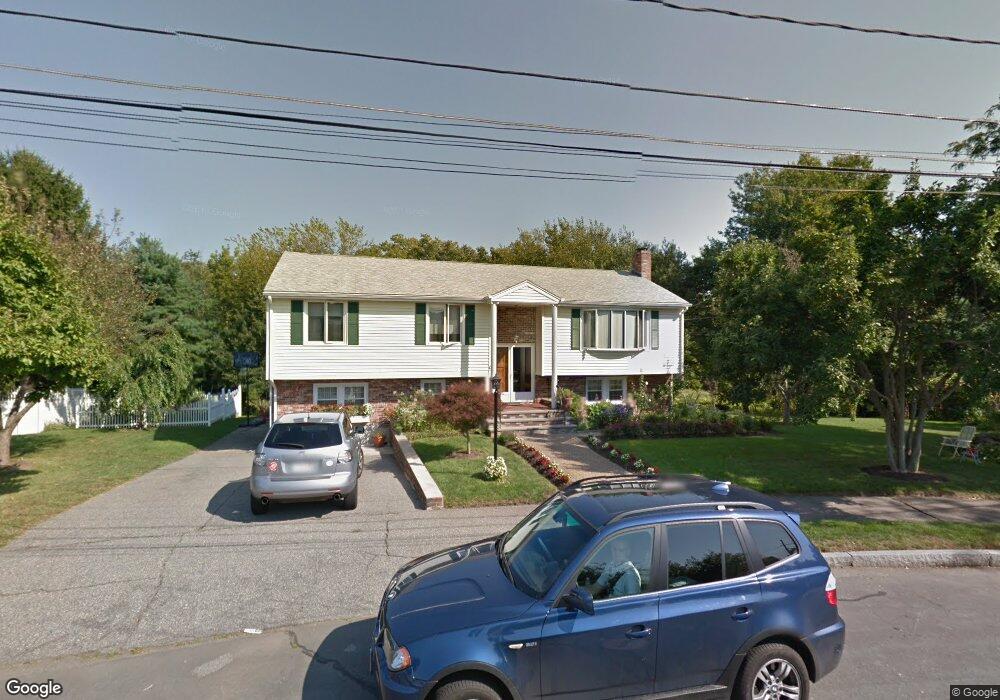
10 Longbow Rd Wakefield, MA 01880
West Side NeighborhoodEstimated Value: $860,000 - $1,226,000
4
Beds
3
Baths
3,114
Sq Ft
$350/Sq Ft
Est. Value
About This Home
This home is located at 10 Longbow Rd, Wakefield, MA 01880 and is currently estimated at $1,090,096, approximately $350 per square foot. 10 Longbow Rd is a home located in Middlesex County with nearby schools including Wakefield Memorial High School, St Joseph School, and St. Patrick Elementary School.
Ownership History
Date
Name
Owned For
Owner Type
Purchase Details
Closed on
May 16, 2017
Sold by
Derenzis Maria
Bought by
Maria Derenzis Ft
Current Estimated Value
Purchase Details
Closed on
Jan 4, 2001
Sold by
Bernadina Rt
Bought by
Dacova Virginia and Dacova Jose A
Home Financials for this Owner
Home Financials are based on the most recent Mortgage that was taken out on this home.
Original Mortgage
$120,000
Interest Rate
7.69%
Mortgage Type
Purchase Money Mortgage
Create a Home Valuation Report for This Property
The Home Valuation Report is an in-depth analysis detailing your home's value as well as a comparison with similar homes in the area
Home Values in the Area
Average Home Value in this Area
Purchase History
| Date | Buyer | Sale Price | Title Company |
|---|---|---|---|
| Maria Derenzis Ft | -- | -- | |
| Dacova Virginia | $430,000 | -- |
Source: Public Records
Mortgage History
| Date | Status | Borrower | Loan Amount |
|---|---|---|---|
| Previous Owner | Dacova Virginia | $120,000 |
Source: Public Records
Tax History
| Year | Tax Paid | Tax Assessment Tax Assessment Total Assessment is a certain percentage of the fair market value that is determined by local assessors to be the total taxable value of land and additions on the property. | Land | Improvement |
|---|---|---|---|---|
| 2025 | $10,723 | $944,800 | $422,700 | $522,100 |
| 2024 | $10,317 | $917,100 | $410,300 | $506,800 |
| 2023 | $9,961 | $849,200 | $379,900 | $469,300 |
| 2022 | $9,511 | $772,000 | $345,300 | $426,700 |
| 2021 | $8,860 | $696,000 | $323,500 | $372,500 |
| 2020 | $8,520 | $667,200 | $310,100 | $357,100 |
| 2019 | $8,266 | $644,300 | $299,400 | $344,900 |
| 2018 | $7,821 | $603,900 | $280,700 | $323,200 |
| 2017 | $7,495 | $575,200 | $267,300 | $307,900 |
| 2016 | $7,000 | $518,900 | $248,800 | $270,100 |
| 2015 | $6,539 | $485,100 | $232,600 | $252,500 |
| 2014 | $6,007 | $470,000 | $225,300 | $244,700 |
Source: Public Records
Map
Nearby Homes
- 20 W Park Dr
- 35 Woodland Rd Unit B
- 34 Woodland Rd
- 346 Albion St
- 12 Theresa Rd
- 3 Theresa Rd
- 159 Broadway St
- 181 Green St
- 293 Albion St
- 126 Green St
- 7 Ballister St Unit 428
- 106 Elm St
- 248 Albion St Unit 324
- 12 Lovis Ave
- 62 Foundry St Unit 312
- 62 Foundry St Unit 409
- 62 Foundry St Unit 505
- 62 Foundry St Unit 208
- 62 Foundry St Unit 202
- 3 Walnut St
Your Personal Tour Guide
Ask me questions while you tour the home.