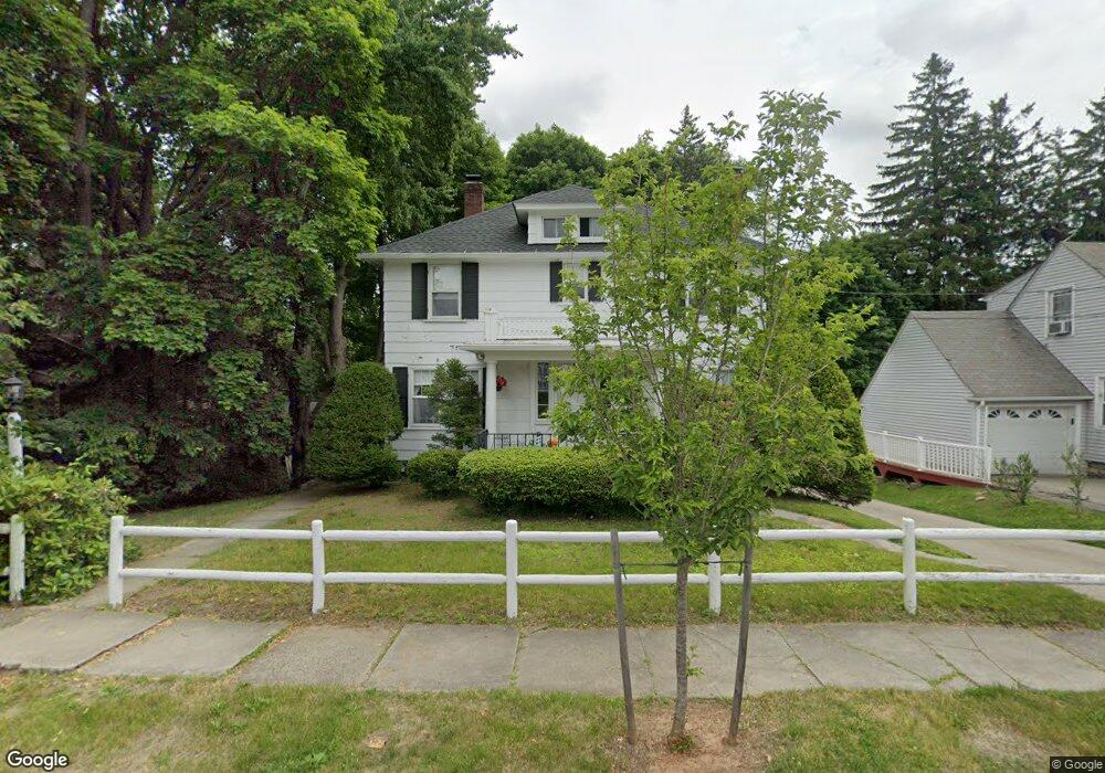
10 Lyndale Rd Worcester, MA 01606
Burncoat NeighborhoodEstimated Value: $405,000 - $459,000
4
Beds
2
Baths
1,488
Sq Ft
$286/Sq Ft
Est. Value
About This Home
This home is located at 10 Lyndale Rd, Worcester, MA 01606 and is currently estimated at $426,044, approximately $286 per square foot. 10 Lyndale Rd is a home located in Worcester County with nearby schools including Jacob Hiatt Magnet School, Chandler Magnet, and Thorndyke Road School.
Create a Home Valuation Report for This Property
The Home Valuation Report is an in-depth analysis detailing your home's value as well as a comparison with similar homes in the area
Home Values in the Area
Average Home Value in this Area
Tax History
We collect this data history from publicly available records. To have your information removed, we recommend requesting removal directly through your county’s website.
| Year | Tax Paid | Tax Assessment Tax Assessment Total Assessment is a certain percentage of the fair market value that is determined by local assessors to be the total taxable value of land and additions on the property. | Land | Improvement |
|---|---|---|---|---|
| 2025 | $4,155 | $315,000 | $117,900 | $197,100 |
| 2024 | $4,111 | $299,000 | $117,900 | $181,100 |
| 2023 | $3,923 | $273,600 | $102,500 | $171,100 |
| 2022 | $3,591 | $236,100 | $82,000 | $154,100 |
| 2021 | $3,416 | $209,800 | $65,600 | $144,200 |
| 2020 | $3,347 | $196,900 | $65,600 | $131,300 |
| 2019 | $3,227 | $179,300 | $59,000 | $120,300 |
| 2018 | $3,232 | $170,900 | $59,000 | $111,900 |
| 2017 | $3,139 | $163,300 | $59,000 | $104,300 |
| 2016 | $3,030 | $147,000 | $43,000 | $104,000 |
| 2015 | $2,950 | $147,000 | $43,000 | $104,000 |
| 2014 | $2,872 | $147,000 | $43,000 | $104,000 |
Source: Public Records
Map
Nearby Homes
- 4 Marmion Ave
- 223 Beverly Rd
- 45 Bay State Rd
- 53 Hillcroft Ave
- 40 Calumet Ave
- 85 Kalmar St
- 21 Dorothy Ave
- 11 Granville Ave
- 19 Calumet Ave
- 2 Jeppson Ave
- 46 North Pkwy
- 4302 Halcyon Dr Unit 4302
- 2 Davidson Rd
- 35 Summerhill Ave
- 78 Leeds St
- 53 Barber Ave
- 28 Greendale Ave
- 25 Kenwood Ave
- 64 Fales St
- 1 Summerhill Ave
- 16 Lyndale Rd
- 14 Lyndale Rd
- 12 Lyndale Rd
- 20 Thorndyke Rd
- 18 Lyndale Rd
- 16 Thorndyke Rd
- 13 Graystone Cir
- 12 Thorndyke Rd
- 9 Graystone Cir
- 8 Lyndale Rd
- 19 Graystone Cir
- 11 Lyndale Rd
- 15 Lyndale Rd
- 44 Thorndyke Rd
- 29 Thorndyke Rd
- 21 Thorndyke Rd
- 6 Lyndale Rd
- 7 Lyndale Rd
- 221 Burncoat St
- 31 Thorndyke Rd
Your Personal Tour Guide
Ask me questions while you tour the home.