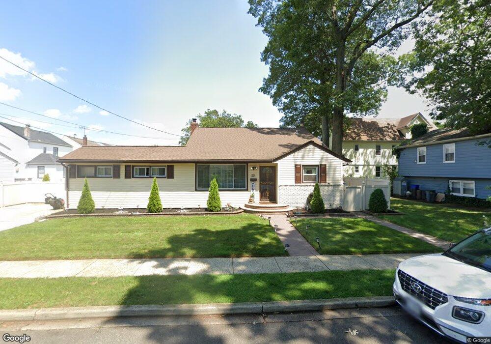
10 Powell St Freeport, NY 11520
Estimated Value: $611,000 - $657,000
3
Beds
2
Baths
1,044
Sq Ft
$600/Sq Ft
Est. Value
About This Home
This home is located at 10 Powell St, Freeport, NY 11520 and is currently estimated at $626,215, approximately $599 per square foot. 10 Powell St is a home located in Nassau County with nearby schools including Roosevelt Middle School, Roosevelt High School, and Roosevelt Children's Academy.
Ownership History
Date
Name
Owned For
Owner Type
Purchase Details
Closed on
Nov 15, 2021
Sold by
Polissaint Susan
Bought by
Mira Jhon J Duque
Current Estimated Value
Home Financials for this Owner
Home Financials are based on the most recent Mortgage that was taken out on this home.
Original Mortgage
$427,500
Interest Rate
3.05%
Mortgage Type
New Conventional
Purchase Details
Closed on
Oct 19, 2000
Sold by
James Janet Coles A K
Bought by
Polissaint Susan
Create a Home Valuation Report for This Property
The Home Valuation Report is an in-depth analysis detailing your home's value as well as a comparison with similar homes in the area
Home Values in the Area
Average Home Value in this Area
Purchase History
We collect this data history from publicly available records. To have your information removed, we recommend requesting removal directly through your county’s website.
| Date | Buyer | Sale Price | Title Company |
|---|---|---|---|
| Mira Jhon J Duque | $450,000 | None Available | |
| Polissaint Susan | $180,000 | Lawrence Natalie |
Source: Public Records
Mortgage History
We collect this data history from publicly available records. To have your information removed, we recommend requesting removal directly through your county’s website.
| Date | Status | Borrower | Loan Amount |
|---|---|---|---|
| Previous Owner | Mira Jhon J Duque | $427,500 |
Source: Public Records
Tax History
| Year | Tax Paid | Tax Assessment Tax Assessment Total Assessment is a certain percentage of the fair market value that is determined by local assessors to be the total taxable value of land and additions on the property. | Land | Improvement |
|---|---|---|---|---|
| 2025 | $6,663 | $362 | $123 | $239 |
| 2024 | $812 | $362 | $123 | $239 |
| 2023 | $6,567 | $362 | $123 | $239 |
| 2022 | $6,567 | $361 | $123 | $238 |
| 2021 | $7,795 | $341 | $116 | $225 |
| 2020 | $5,363 | $546 | $275 | $271 |
| 2019 | $906 | $546 | $275 | $271 |
| 2018 | $4,103 | $546 | $0 | $0 |
| 2017 | $3,832 | $546 | $275 | $271 |
| 2016 | $4,651 | $546 | $275 | $271 |
| 2015 | $789 | $546 | $275 | $271 |
| 2014 | $789 | $546 | $275 | $271 |
| 2013 | $745 | $546 | $275 | $271 |
Source: Public Records
Map
Nearby Homes
- 110 Woodside Ave
- 188 Woodside Ave
- 29 Colonial Ave
- 22 Colonial Ave
- 67 Ellison Ave
- 400 N Columbus Ave
- 50 Leonard Ave
- 398 Babylon Turnpike
- 48 Pleasant Ave
- 24 Underhill Ave
- 24 Pleasant Ave
- 247 N Columbus Ave
- 261 Rutland Rd
- 173 E Seaman Ave
- 101 Harris Ave
- 65 Mount Joy Ave
- 67 E Dean St
- 16 Scherer Place
- 216 N Ocean Ave
- 160 E Fulton Ave
- 20 Powell St
- 108 Woodside Ave
- 95 Colonial Ave
- 99 Colonial Ave
- 99 Colonial Ave Unit 2
- 7 Powell St
- 107 Colonial Ave
- 21 Powell St
- 112 Woodside Ave
- 3 Powell St
- 109 Colonial Ave
- 84 Woodside Ave
- 116 Woodside Ave
- 81 Colonial Ave
- 113 Colonial Ave
- 82 Woodside Ave
- 103 Woodside Ave
- 120 Woodside Ave
- 104 Colonial Ave
- 106 Colonial Ave
Your Personal Tour Guide
Ask me questions while you tour the home.