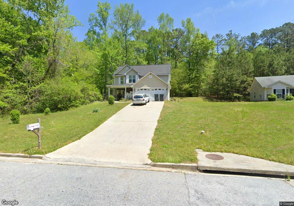
100 Railside Dr Covington, GA 30014
Covington AreaEstimated Value: $268,000 - $308,000
About This Home
This home is located at 100 Railside Dr, Covington, GA 30014 and is currently estimated at $284,004, approximately $161 per square foot. 100 Railside Dr is a home located in Newton County with nearby schools including Heard-Mixon Elementary School, Cousins Middle School, and Eastside High School.
Ownership History
We collect this data history from publicly available records. To have your information removed, we recommend requesting removal directly through your county’s website.
Purchase Details
Home Financials for this Owner
Home Financials are based on the most recent Mortgage that was taken out on this home.Purchase Details
Purchase Details
Purchase Details
Purchase Details
Home Values in the Area
Average Home Value in this Area
Purchase History
We collect this data history from publicly available records. To have your information removed, we recommend requesting removal directly through your county’s website.
| Date | Buyer | Sale Price | Title Company |
|---|---|---|---|
| -- | -- | ||
| $58,500 | -- | ||
| -- | -- | ||
| $58,500 | -- | ||
| -- | -- | ||
| $86,900 | -- | ||
| $114,075 | -- | ||
| $140,000 | -- |
Mortgage History
We collect this data history from publicly available records. To have your information removed, we recommend requesting removal directly through your county’s website.
| Date | Status | Borrower | Loan Amount |
|---|---|---|---|
| Previous Owner | $47,200 |
Tax History
We collect this data history from publicly available records. To have your information removed, we recommend requesting removal directly through your county’s website.
| Year | Tax Paid | Tax Assessment Tax Assessment Total Assessment is a certain percentage of the fair market value that is determined by local assessors to be the total taxable value of land and additions on the property. | Land | Improvement |
|---|---|---|---|---|
| 2025 | $3,021 | $118,520 | $15,200 | $103,320 |
| 2024 | $2,883 | $110,960 | $15,200 | $95,760 |
| 2023 | $2,829 | $101,600 | $6,400 | $95,200 |
| 2022 | $2,489 | $82,080 | $6,400 | $75,680 |
| 2021 | $2,153 | $68,600 | $6,400 | $62,200 |
| 2020 | $1,890 | $54,160 | $6,400 | $47,760 |
| 2019 | $1,635 | $45,880 | $6,400 | $39,480 |
| 2018 | $1,298 | $35,760 | $5,000 | $30,760 |
| 2017 | $1,308 | $36,040 | $3,800 | $32,240 |
| 2016 | $1,308 | $36,040 | $3,800 | $32,240 |
| 2015 | $1,264 | $34,800 | $3,200 | $31,600 |
| 2014 | $1,260 | $34,800 | $0 | $0 |
Map
- 450 E End Rd
- 90 Cedar Creek Dr
- 10717 Highway 36
- 20 Bellflower Walk
- 15 Kestrel Cir Unit 2
- 10724 Highway 36
- 65 Foxgrove
- 11028 Highway 36
- 398 River Walk Farm Pkwy
- 391 River Walk Farm Pkwy
- 45 Rosemoore Dr
- 60 Snapdragon Ln
- 16 River Walk Farm Pkwy
- 18 River Walk Farm Pkwy
- 20 Stoney Point Terrace
- 370 Granary Walk
- 26 River Walk Farm Pkwy
- 433 River Walk Farms Pkwy
- 439 River Walk Farm Pkwy
- 105 Sagebrush Trail
Ask me questions while you tour the home.