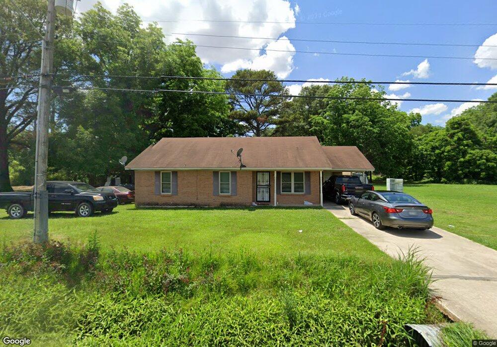
1006 N Main St Dermott, AR 71638
Estimated Value: $53,404 - $149,000
Studio
1
Bath
1,122
Sq Ft
$77/Sq Ft
Est. Value
About This Home
This home is located at 1006 N Main St, Dermott, AR 71638 and is currently estimated at $86,351, approximately $76 per square foot. 1006 N Main St is a home located in Chicot County with nearby schools including Dermott Elementary School and Dermott High School.
Ownership History
Date
Name
Owned For
Owner Type
Purchase Details
Closed on
Dec 4, 2013
Sold by
Brown John and John Brown I
Bought by
Brown Almira
Current Estimated Value
Purchase Details
Closed on
Apr 6, 2009
Sold by
United States Of America Acting Through
Bought by
Brown John W and John W Brown I
Purchase Details
Closed on
Sep 9, 2008
Bought by
Farmers Home Admn Dept Agri
Purchase Details
Closed on
Dec 16, 2002
Bought by
Strickland Gearld
Purchase Details
Closed on
Jun 24, 1999
Bought by
Williams Evora
Purchase Details
Closed on
Jul 1, 1994
Bought by
Williams Evora
Create a Home Valuation Report for This Property
The Home Valuation Report is an in-depth analysis detailing your home's value as well as a comparison with similar homes in the area
Home Values in the Area
Average Home Value in this Area
Purchase History
| Date | Buyer | Sale Price | Title Company |
|---|---|---|---|
| Brown Almira | -- | -- | |
| Brown John W | $16,275 | -- | |
| Farmers Home Admn Dept Agri | $16,100 | -- | |
| Strickland Gearld | $1,900 | -- | |
| Adams Richard | $100 | -- | |
| Williams Evora | -- | -- | |
| Williams Evora | -- | -- |
Source: Public Records
Tax History
| Year | Tax Paid | Tax Assessment Tax Assessment Total Assessment is a certain percentage of the fair market value that is determined by local assessors to be the total taxable value of land and additions on the property. | Land | Improvement |
|---|---|---|---|---|
| 2025 | $80 | $6,060 | $640 | $5,420 |
| 2024 | $278 | $6,060 | $640 | $5,420 |
| 2023 | $254 | $5,040 | $640 | $4,400 |
| 2022 | $56 | $5,040 | $640 | $4,400 |
| 2021 | $56 | $5,040 | $640 | $4,400 |
| 2020 | $232 | $5,040 | $640 | $4,400 |
| 2019 | $49 | $5,040 | $640 | $4,400 |
| 2018 | $39 | $3,740 | $400 | $3,340 |
| 2017 | $210 | $3,720 | $400 | $3,320 |
| 2016 | $36 | $3,720 | $400 | $3,320 |
| 2015 | -- | $3,720 | $400 | $3,320 |
| 2014 | -- | $3,720 | $400 | $3,320 |
| 2013 | -- | $3,720 | $400 | $3,320 |
Source: Public Records
Map
Nearby Homes
- 1009 N Trotter St
- 0 N Main St
- Lot 12 W Mulberry St
- 0 W Mulberry St
- Lot 7 W Matthews St
- 0 N Trotter St
- 0 E Hickory St
- Lot 1 N Hardy St
- Lot 6 N Knox St
- Lot 7 N Wolf St
- 904 Elk St
- Lot 6 N Alma St
- Lot 5 Deer St
- 305 N School St
- 221 School Dr
- 0 Wolfe St
- Lots 10-11 Wolfe St
- 604 E Howard St
- 407 N Shepherd St
- Lot 7 W Ash St
- 1017 N Trotter St
- 933 N Main St
- 924 N Trotter St
- 920 N Trotter St
- 902 N Trotter St
- 107 N School St
- 900 N Main St
- 106 W Hazel St
- 1001 N School St
- 917 N School St
- 903 N Trotter St
- 1031 N Trotter St
- 900 N Trotter St
- 911 N School St
- 1016 N School St
- 1008 N School St
- 1000 N School St
- 1104 N Trotter St
- 1018 N School St
- 916 N School St
Your Personal Tour Guide
Ask me questions while you tour the home.