101 Boulder Dr Mount Orab, OH 45154
Estimated Value: $221,000 - $387,000
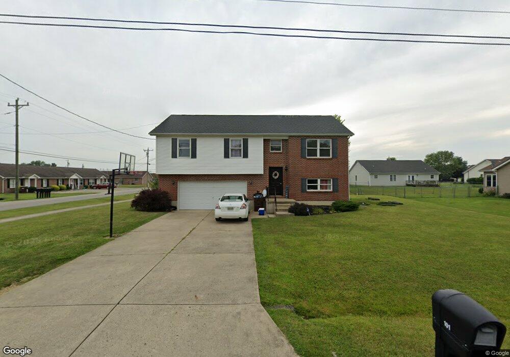
About This Home
This home is located at 101 Boulder Dr, Mount Orab, OH 45154 and is currently estimated at $290,333. 101 Boulder Dr is a home located in Brown County with nearby schools including Western Brown High School.
Ownership History
We collect this data history from publicly available records. To have your information removed, we recommend requesting removal directly through your county’s website.
Purchase Details
Home Financials for this Owner
Home Financials are based on the most recent Mortgage that was taken out on this home.Purchase Details
Purchase Details
Home Financials for this Owner
Home Financials are based on the most recent Mortgage that was taken out on this home.Purchase Details
Home Financials for this Owner
Home Financials are based on the most recent Mortgage that was taken out on this home.Purchase Details
Home Financials for this Owner
Home Financials are based on the most recent Mortgage that was taken out on this home.Home Values in the Area
Average Home Value in this Area
Purchase History
We collect this data history from publicly available records. To have your information removed, we recommend requesting removal directly through your county’s website.
| Date | Buyer | Sale Price | Title Company |
|---|---|---|---|
| -- | None Available | ||
| $105,756 | None Available | ||
| $132,900 | Advanced Land Title Agency | ||
| $121,900 | -- | ||
| $142,140 | -- |
Mortgage History
We collect this data history from publicly available records. To have your information removed, we recommend requesting removal directly through your county’s website.
| Date | Status | Borrower | Loan Amount |
|---|---|---|---|
| Previous Owner | $115,225 | ||
| Previous Owner | $135,757 | ||
| Previous Owner | $97,520 | ||
| Previous Owner | $500,000 | ||
| Closed | $24,380 |
Tax History
We collect this data history from publicly available records. To have your information removed, we recommend requesting removal directly through your county’s website.
| Year | Tax Paid | Tax Assessment Tax Assessment Total Assessment is a certain percentage of the fair market value that is determined by local assessors to be the total taxable value of land and additions on the property. | Land | Improvement |
|---|---|---|---|---|
| 2025 | $151 | $4,730 | $4,730 | $0 |
| 2024 | $151 | $4,730 | $4,730 | $0 |
| 2023 | $151 | $4,160 | $4,160 | $0 |
| 2022 | $143 | $4,160 | $4,160 | $0 |
| 2021 | $138 | $4,160 | $4,160 | $0 |
| 2020 | $121 | $3,470 | $3,470 | $0 |
| 2019 | $129 | $3,470 | $3,470 | $0 |
| 2018 | $128 | $3,470 | $3,470 | $0 |
| 2017 | $131 | $3,470 | $3,470 | $0 |
| 2016 | $131 | $3,470 | $3,470 | $0 |
| 2015 | $117 | $3,470 | $3,470 | $0 |
| 2014 | $117 | $3,150 | $3,150 | $0 |
| 2013 | $117 | $3,150 | $3,150 | $0 |
Map
- 115 Sweet Bay Trail
- 130 Willow Run Rd
- 102 Kayleigh Dr
- 103 Kayleigh Dr
- 107 Toms Turnaround
- 610 S High St
- 104 N High St
- 111 Beacon Hill Dr
- 0 State Route 32 Unit 1795308
- 108 Keethler St
- 0 Crescent Dr Unit 1876227
- 321 Pleasant St
- 506 E Main St
- 781 S High St
- 0 Hess Rd Unit 1880039
- 3738 Lake Grant Access Rd
- 224 Gregory St
- 216 Gregory St
- 419 Liming Farm Rd
- 328 Glover Meadows Way
- 101 Boulder Dr
- 103 Boulder Dr
- 100 Nathans Ln
- 102 Boulder Dr
- 185 Boyd Rd Unit 189
- 102 Nathans Ln
- 104 Boulder Dr
- 105 Boulder Dr
- 104 Nathans Ln
- 205 Boyd Rd
- 106 Boulder Dr
- 103 Stone Trace Dr
- 101 Nathans Ln
- 101 Stone Trace Dr
- 103 Nathans Ln
- 105 Stone Trace Dr
- 107 Boulder Dr
- 105 Nathans Ln
- 102 Stone Trace Dr
- 100 Baylie Dr
Ask me questions while you tour the home.