101 N Route E Curryville, MO 63339
Estimated Value: $143,000 - $439,000
3
Beds
4
Baths
1,708
Sq Ft
$145/Sq Ft
Est. Value
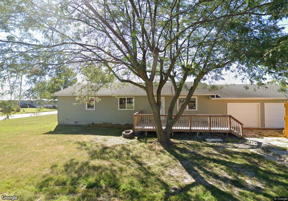
About This Home
This home is located at 101 N Route E, Curryville, MO 63339 and is currently estimated at $247,878, approximately $145 per square foot. 101 N Route E is a home with nearby schools including Bowling Green High School.
Ownership History
Date
Name
Owned For
Owner Type
Purchase Details
Closed on
Sep 26, 2025
Sold by
Stallion Properties Llc
Bought by
Harvey Jordan and Harvey Kristina
Current Estimated Value
Home Financials for this Owner
Home Financials are based on the most recent Mortgage that was taken out on this home.
Original Mortgage
$194,000
Outstanding Balance
$194,000
Interest Rate
6.58%
Mortgage Type
New Conventional
Estimated Equity
$53,878
Purchase Details
Closed on
May 23, 2024
Sold by
Grote Sallie A
Bought by
Stallion Properties Llc
Home Financials for this Owner
Home Financials are based on the most recent Mortgage that was taken out on this home.
Original Mortgage
$100,000
Interest Rate
6.88%
Mortgage Type
Construction
Create a Home Valuation Report for This Property
The Home Valuation Report is an in-depth analysis detailing your home's value as well as a comparison with similar homes in the area
Purchase History
| Date | Buyer | Sale Price | Title Company |
|---|---|---|---|
| Harvey Jordan | -- | None Listed On Document | |
| Stallion Properties Llc | -- | None Listed On Document |
Source: Public Records
Mortgage History
| Date | Status | Borrower | Loan Amount |
|---|---|---|---|
| Open | Harvey Jordan | $194,000 | |
| Previous Owner | Stallion Properties Llc | $100,000 |
Source: Public Records
Tax History
| Year | Tax Paid | Tax Assessment Tax Assessment Total Assessment is a certain percentage of the fair market value that is determined by local assessors to be the total taxable value of land and additions on the property. | Land | Improvement |
|---|---|---|---|---|
| 2025 | $896 | $16,150 | $720 | $15,430 |
| 2024 | $895 | $16,150 | $720 | $15,430 |
| 2023 | $895 | $16,150 | $720 | $15,430 |
| 2022 | $766 | $13,910 | $720 | $13,190 |
| 2021 | $761 | $13,910 | $720 | $13,190 |
| 2020 | $765 | $13,910 | $720 | $13,190 |
| 2019 | $763 | $13,910 | $720 | $13,190 |
| 2018 | $685 | $13,800 | $610 | $13,190 |
| 2017 | $681 | $13,800 | $610 | $13,190 |
| 2016 | $653 | $13,550 | $610 | $12,940 |
| 2015 | -- | $13,550 | $610 | $12,940 |
| 2011 | -- | $13,550 | $610 | $12,940 |
Source: Public Records
Map
Nearby Homes
- 14144 Highway E
- 2601 Pike 25
- 1175 Pike 41
- 4710 Pike 451
- 0000 Pike 443
- 12838 Pike 403
- TBD Pike 409
- 1149 E US Highway 54
- 0 Pike 403 Unit MIS24029296
- 0 S 13th St Unit MAR23052764
- 103 S 13th St
- 1203 W Main St
- 1206 W Locust St
- 1106 W Centennial Ave
- 406 S Utterback St
- 915 W Maple St
- 905 W Maple St
- 413 N 8th St
- 00 Highway 61 Outer Rd
- 419 W Main St
- 105 S Route M
- 101 S Locust St
- 205 N Route E
- 101 Hwy 54
- 0 U S 54
- 305 W Main St
- 0 100+ - Acres On Highway M
- 0 40 + - Acres On Highway M Unit 21056122
- 207 W Main St
- 304 N Route E
- 307 W Main St
- 208 W Main St
- 201 W Main St
- 105 Hwy M
- 205 W Main St
- 308 W Maple St
- 16.5 Ac m/l Highway M
- 309 W Main St
- 308 Hwy 54w
- 310 W Maple St
Your Personal Tour Guide
Ask me questions while you tour the home.