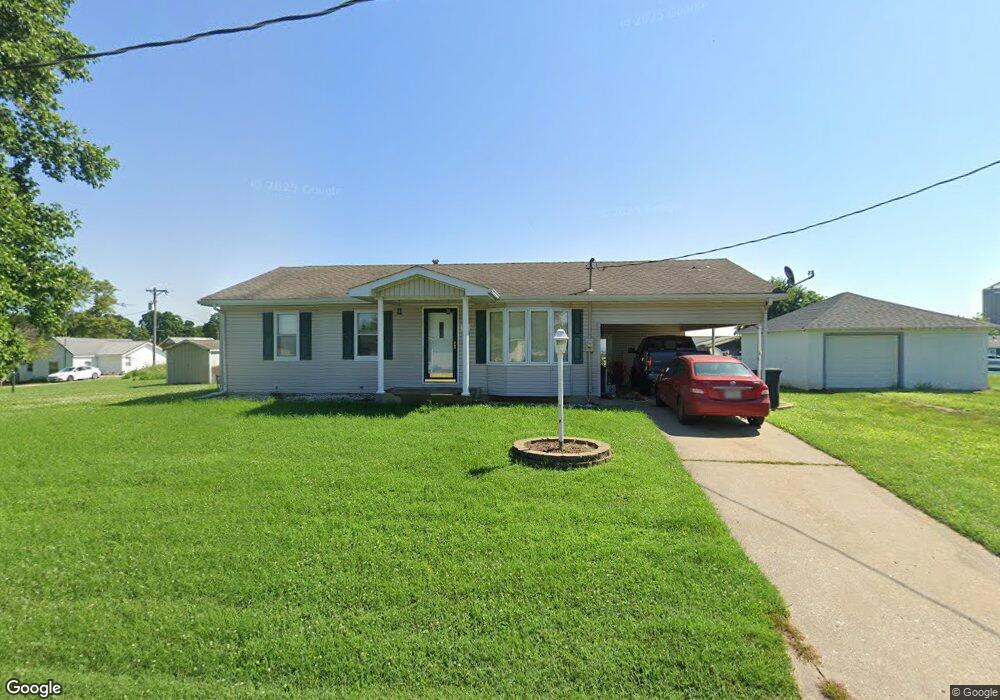
101 W Roe St Pilot Grove, MO 65276
Estimated Value: $126,000 - $217,000
3
Beds
1
Bath
1,500
Sq Ft
$110/Sq Ft
Est. Value
About This Home
This home is located at 101 W Roe St, Pilot Grove, MO 65276 and is currently estimated at $165,272, approximately $110 per square foot. 101 W Roe St is a home located in Cooper County with nearby schools including Pilot Grove Elementary School, Pilot Grove High School, and St. Joseph Elementary School.
Ownership History
Date
Name
Owned For
Owner Type
Purchase Details
Closed on
Dec 20, 2017
Sold by
Eckerle Darell H and Eckerle Constance J
Bought by
Lewis Joshua D
Current Estimated Value
Home Financials for this Owner
Home Financials are based on the most recent Mortgage that was taken out on this home.
Original Mortgage
$94,505
Outstanding Balance
$79,149
Interest Rate
3.92%
Mortgage Type
New Conventional
Estimated Equity
$86,123
Create a Home Valuation Report for This Property
The Home Valuation Report is an in-depth analysis detailing your home's value as well as a comparison with similar homes in the area
Purchase History
| Date | Buyer | Sale Price | Title Company |
|---|---|---|---|
| Lewis Joshua D | -- | None Available |
Source: Public Records
Mortgage History
| Date | Status | Borrower | Loan Amount |
|---|---|---|---|
| Open | Lewis Joshua D | $94,505 |
Source: Public Records
Tax History
| Year | Tax Paid | Tax Assessment Tax Assessment Total Assessment is a certain percentage of the fair market value that is determined by local assessors to be the total taxable value of land and additions on the property. | Land | Improvement |
|---|---|---|---|---|
| 2025 | $766 | $10,660 | $0 | $0 |
| 2024 | $766 | $9,900 | $0 | $0 |
| 2023 | $713 | $9,900 | $0 | $0 |
| 2022 | $616 | $9,120 | $0 | $0 |
| 2021 | $533 | $7,900 | $0 | $0 |
| 2020 | $542 | $7,520 | $0 | $0 |
| 2019 | $537 | $7,520 | $0 | $7,520 |
| 2018 | $497 | $7,520 | $0 | $7,520 |
| 2017 | $512 | $6,950 | $0 | $6,950 |
| 2016 | -- | $6,950 | $0 | $0 |
| 2015 | -- | $6,950 | $0 | $0 |
| 2011 | -- | $6,950 | $0 | $0 |
Source: Public Records
Map
Nearby Homes
- 208 College St
- 110 3rd St
- 500 4th St
- 11503 Hawk Hill Ln
- TBD Hwy Nn
- LOT 91 Madewood Rd
- 250ac Tbd Z Hwy
- 0 Ferry Rd
- 10469 Ferry Rd
- 12217 Ferry Rd
- Tbd Hwy Z
- 13915 Old Highway 40
- 20671 K Hwy
- LOT 205 Mid-America Industrial Ct
- LOT 202 Mid-America Industrial Ct
- LOT 17A Mid-America Industrial Ct
- LOT 16 Mid-America Industrial Ct
- 220 Acres M L Ferry Rd
- 303 Trigg Ave
- LOT 207 Fuqua Dr
Your Personal Tour Guide
Ask me questions while you tour the home.