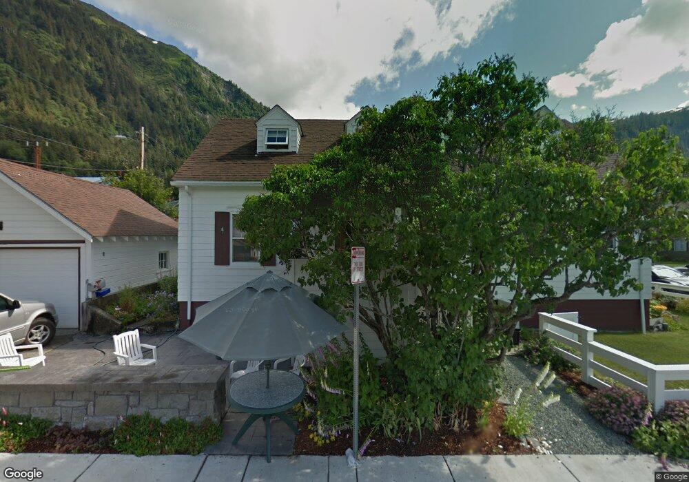
1011 D St Juneau, AK 99801
Downtown Juneau NeighborhoodEstimated Value: $613,000 - $744,000
Studio
2
Baths
1,900
Sq Ft
$356/Sq Ft
Est. Value
About This Home
This home is located at 1011 D St, Juneau, AK 99801 and is currently estimated at $675,737, approximately $355 per square foot. 1011 D St is a home located in Juneau City and Borough with nearby schools including Harborview Elementary School and Juneau Community Charter School.
Ownership History
Date
Name
Owned For
Owner Type
Purchase Details
Closed on
Jun 6, 2025
Sold by
Field Addison and Pugh Myra
Bought by
Field Pugh Living Trust and Field
Current Estimated Value
Purchase Details
Closed on
Dec 13, 2019
Sold by
Pugh John R and Pugh Margaret M
Bought by
Field Addison and Pugh Myra
Home Financials for this Owner
Home Financials are based on the most recent Mortgage that was taken out on this home.
Original Mortgage
$527,863
Interest Rate
3.7%
Mortgage Type
VA
Create a Home Valuation Report for This Property
The Home Valuation Report is an in-depth analysis detailing your home's value as well as a comparison with similar homes in the area
Home Values in the Area
Average Home Value in this Area
Purchase History
| Date | Buyer | Sale Price | Title Company |
|---|---|---|---|
| Field Pugh Living Trust | -- | None Listed On Document | |
| Field Addison | -- | None Available |
Source: Public Records
Mortgage History
| Date | Status | Borrower | Loan Amount |
|---|---|---|---|
| Previous Owner | Field Addison | $527,863 |
Source: Public Records
Tax History
| Year | Tax Paid | Tax Assessment Tax Assessment Total Assessment is a certain percentage of the fair market value that is determined by local assessors to be the total taxable value of land and additions on the property. | Land | Improvement |
|---|---|---|---|---|
| 2025 | $6,680 | $652,300 | $199,800 | $452,500 |
| 2024 | $6,249 | $622,400 | $199,800 | $422,600 |
| 2023 | $6,172 | $607,500 | $199,800 | $407,700 |
| 2022 | $5,935 | $562,000 | $181,500 | $380,500 |
| 2021 | $5,165 | $489,100 | $181,500 | $307,600 |
| 2020 | $5,132 | $481,400 | $181,500 | $299,900 |
| 2019 | $3,614 | $489,030 | $161,913 | $327,117 |
| 2018 | $3,244 | $489,030 | $161,913 | $327,117 |
| 2017 | $3,244 | $472,493 | $156,438 | $316,055 |
| 2016 | $3,244 | $454,320 | $150,421 | $303,899 |
| 2015 | -- | $420,667 | $139,279 | $281,388 |
| 2014 | -- | $401,400 | $132,900 | $268,500 |
Source: Public Records
Map
Nearby Homes
- 1220 Glacier Ave Unit 307
- 800 F St Unit 2
- 275 Irwin St
- 1600 Harbor Way Unit Aurora Harbor, M32
- 421 Judy Ln Unit 423 Judy Lane
- 411 3rd St
- 411 3rd St Unit 235 Gold Street
- 1926 Glacier Ave
- 3030 Foster Ave
- 3185 Pioneer Ave
- 0 Pioneer Ave
- 2961 Simpson Ave
- 2753 John St
- 2909 Simpson Ave
- 2892 Simpson Ave
- 0 Merritt Rd
- NHN Vista Dr
- 2350 Old Lawson Creek Rd
- 2551 Vista Dr Unit D-101
- 1853 Bartlett Ave
Your Personal Tour Guide
Ask me questions while you tour the home.