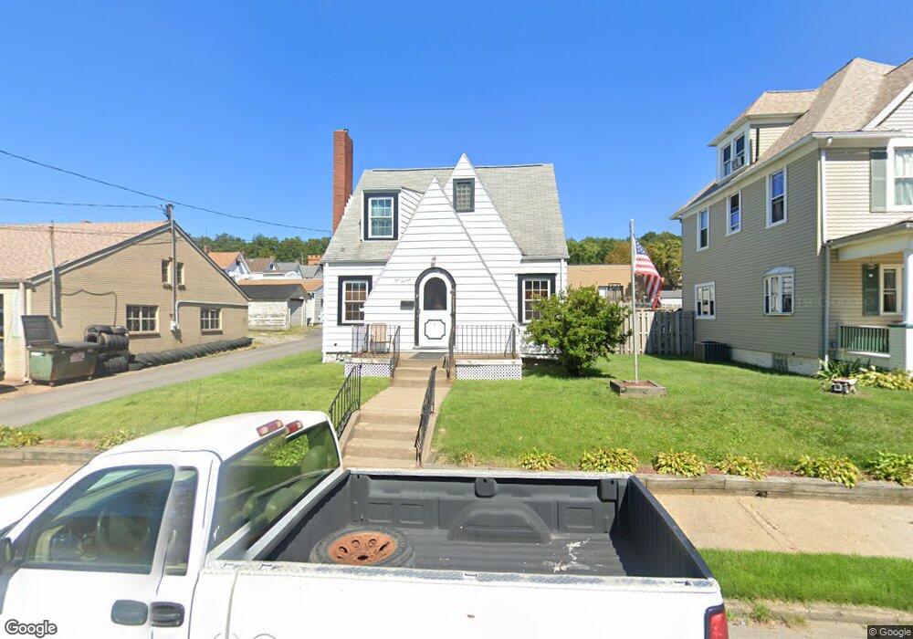
1013 2nd Ave Conway, PA 15027
Estimated Value: $138,000 - $177,149
2
Beds
1
Bath
1,446
Sq Ft
$109/Sq Ft
Est. Value
About This Home
This home is located at 1013 2nd Ave, Conway, PA 15027 and is currently estimated at $157,537, approximately $108 per square foot. 1013 2nd Ave is a home located in Beaver County with nearby schools including Freedom Area Elementary School, Freedom Area Middle School, and Freedom Area Senior High School.
Ownership History
Date
Name
Owned For
Owner Type
Purchase Details
Closed on
Feb 23, 2024
Sold by
Giska William
Bought by
Emery William and Emery Samantha L
Current Estimated Value
Home Financials for this Owner
Home Financials are based on the most recent Mortgage that was taken out on this home.
Original Mortgage
$110,879
Outstanding Balance
$108,916
Interest Rate
6.6%
Mortgage Type
FHA
Estimated Equity
$48,621
Purchase Details
Closed on
Jul 17, 2018
Sold by
Smart Ruth and Giska William
Bought by
Giska William
Purchase Details
Closed on
Oct 11, 2005
Sold by
Boring Herbert M
Bought by
Smart Ruth
Create a Home Valuation Report for This Property
The Home Valuation Report is an in-depth analysis detailing your home's value as well as a comparison with similar homes in the area
Home Values in the Area
Average Home Value in this Area
Purchase History
| Date | Buyer | Sale Price | Title Company |
|---|---|---|---|
| Emery William | $140,000 | Amrock | |
| Giska William | -- | None Available | |
| Smart Ruth | $70,000 | -- |
Source: Public Records
Mortgage History
| Date | Status | Borrower | Loan Amount |
|---|---|---|---|
| Open | Emery William | $110,879 |
Source: Public Records
Tax History
| Year | Tax Paid | Tax Assessment Tax Assessment Total Assessment is a certain percentage of the fair market value that is determined by local assessors to be the total taxable value of land and additions on the property. | Land | Improvement |
|---|---|---|---|---|
| 2025 | $547 | $74,550 | $12,800 | $61,750 |
| 2024 | $2,554 | $74,550 | $12,800 | $61,750 |
| 2023 | $2,968 | $24,150 | $2,400 | $21,750 |
| 2022 | $2,884 | $24,150 | $2,400 | $21,750 |
| 2021 | $2,884 | $24,150 | $2,400 | $21,750 |
| 2020 | $2,688 | $24,150 | $2,400 | $21,750 |
| 2019 | $2,688 | $24,150 | $2,400 | $21,750 |
| 2018 | $2,584 | $24,150 | $2,400 | $21,750 |
| 2017 | $2,584 | $24,150 | $2,400 | $21,750 |
| 2016 | $2,357 | $24,150 | $2,400 | $21,750 |
| 2015 | $536 | $24,150 | $2,400 | $21,750 |
| 2014 | $536 | $24,150 | $2,400 | $21,750 |
Source: Public Records
Map
Nearby Homes
- 1001 2nd Ave
- 1203 2nd Ave
- 1227 Porter St
- 1508 Dupont St
- 1025 Catherine Dr
- 149 Shady River Blvd Unit 40 B
- 150 Shady River Blvd Unit 56A
- 154 Shady River Blvd
- 300 River Ridge Ct
- 328 River Ridge Ct Unit 47B
- 1079 Catherine Dr
- 744 N Gross St
- 245 Conway Wallrose Rd
- 450 Knollwood Cir
- 1010 4th St
- 969 4th St
- 1004 Collins Ave
- 500 Conway Wallrose Rd
- 155 Sproat Ave
- 996 Monaca Rd
Your Personal Tour Guide
Ask me questions while you tour the home.