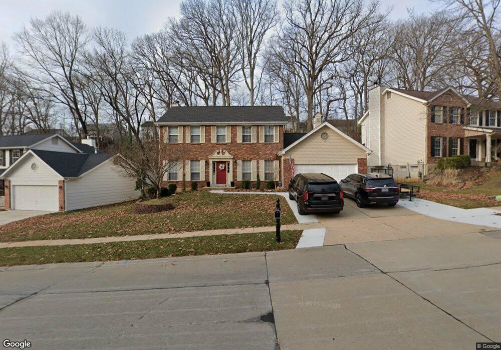
1016 Westrun Dr Ballwin, MO 63021
Estimated Value: $450,044 - $498,000
4
Beds
3
Baths
2,248
Sq Ft
$214/Sq Ft
Est. Value
About This Home
This home is located at 1016 Westrun Dr, Ballwin, MO 63021 and is currently estimated at $480,761, approximately $213 per square foot. 1016 Westrun Dr is a home located in St. Louis County with nearby schools including Woerther Elementary School, Selvidge Middle School, and Marquette Sr. High School.
Ownership History
Date
Name
Owned For
Owner Type
Purchase Details
Closed on
Aug 24, 2012
Sold by
Zhou Yihua and He Li
Bought by
Hunyar David C and Hunyar Elizabeth F
Current Estimated Value
Home Financials for this Owner
Home Financials are based on the most recent Mortgage that was taken out on this home.
Original Mortgage
$36,000
Outstanding Balance
$15,526
Interest Rate
3.49%
Mortgage Type
Unknown
Estimated Equity
$465,235
Purchase Details
Closed on
May 15, 1998
Sold by
Vanek Patrick P and Vanek Carol L
Bought by
Zhou Yihua and He Li
Home Financials for this Owner
Home Financials are based on the most recent Mortgage that was taken out on this home.
Original Mortgage
$153,000
Interest Rate
6.95%
Create a Home Valuation Report for This Property
The Home Valuation Report is an in-depth analysis detailing your home's value as well as a comparison with similar homes in the area
Home Values in the Area
Average Home Value in this Area
Purchase History
| Date | Buyer | Sale Price | Title Company |
|---|---|---|---|
| Hunyar David C | $240,000 | Investors Title Co Clayton | |
| Zhou Yihua | -- | -- |
Source: Public Records
Mortgage History
| Date | Status | Borrower | Loan Amount |
|---|---|---|---|
| Open | Hunyar David C | $36,000 | |
| Open | Hunyar David C | $192,000 | |
| Previous Owner | Zhou Yihua | $153,000 |
Source: Public Records
Tax History
| Year | Tax Paid | Tax Assessment Tax Assessment Total Assessment is a certain percentage of the fair market value that is determined by local assessors to be the total taxable value of land and additions on the property. | Land | Improvement |
|---|---|---|---|---|
| 2025 | $5,075 | $79,840 | $30,040 | $49,800 |
| 2024 | $5,075 | $72,580 | $16,680 | $55,900 |
| 2023 | $5,071 | $72,580 | $16,680 | $55,900 |
| 2022 | $4,689 | $62,310 | $20,030 | $42,280 |
| 2021 | $4,655 | $62,310 | $20,030 | $42,280 |
| 2020 | $4,700 | $59,990 | $20,030 | $39,960 |
| 2019 | $4,719 | $59,990 | $20,030 | $39,960 |
| 2018 | $4,044 | $48,430 | $15,010 | $33,420 |
| 2017 | $3,948 | $48,430 | $15,010 | $33,420 |
| 2016 | $4,210 | $49,690 | $15,010 | $34,680 |
Source: Public Records
Map
Nearby Homes
- 325 Fox Village Ct
- 279 Aspen Village Dr
- 589 Wetherby Terrace Dr
- 1319 Oak Borough Dr
- 847 Palm Bay Dr
- 713 Village Wood Ct
- 725 Whispering Forest Dr
- 318 Statewood Dr
- 677 Rustic Valley Dr
- 643 Nanceen Ct
- 15963 Fox Trotter Ct
- 760 Woodside Trails Dr Unit 203
- 15927 Forest Valley Dr
- 604 Pine Ridge Trails Ct Unit 202
- 217 Carmel Woods Dr Unit 217
- 847 Arbor Chase Dr
- 634 Parker Dr
- 439 Chukker Valley
- 873 Woodside Trails Dr Unit 853
- 1110 Kiefer Creek Rd
- 1012 Westrun Dr
- 1024 Westrun Dr
- 438 Alverston Ct
- 442 Alverston Ct
- 1028 Westrun Dr
- 434 Alverston Ct
- 1004 Westrun Dr
- 446 Alverston Ct
- 308 Alverston Ct
- 312 Alverston Ct
- 430 Alverston Ct
- 316 Alverston Ct
- 450 Alverston Ct
- 320 Alverston Ct
- 1032 Westrun Dr
- 1000 Westrun Dr
- 304 Alverston Ct
- 324 Alverston Ct
- 426 Alverston Ct
- 454 Alverston Ct
Your Personal Tour Guide
Ask me questions while you tour the home.