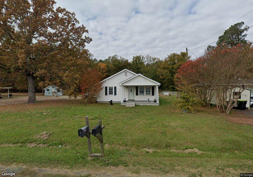
1018 Lewis St Oxford, NC 27565
Estimated Value: $171,538 - $324,000
2
Beds
1
Bath
1,048
Sq Ft
$225/Sq Ft
Est. Value
About This Home
This home is located at 1018 Lewis St, Oxford, NC 27565 and is currently estimated at $235,385, approximately $224 per square foot. 1018 Lewis St is a home located in Granville County with nearby schools including West Oxford Elementary School, Northern Granville Middle School, and Granville Central High School.
Ownership History
Date
Name
Owned For
Owner Type
Purchase Details
Closed on
Nov 16, 2011
Sold by
Federal National Mortgage Association
Bought by
Tran Wind
Current Estimated Value
Purchase Details
Closed on
Feb 27, 2007
Sold by
Harper Patti W and Harper Gary E
Bought by
Nationstar Mortgage Llc
Home Financials for this Owner
Home Financials are based on the most recent Mortgage that was taken out on this home.
Original Mortgage
$65,500
Interest Rate
6.01%
Mortgage Type
New Conventional
Create a Home Valuation Report for This Property
The Home Valuation Report is an in-depth analysis detailing your home's value as well as a comparison with similar homes in the area
Purchase History
| Date | Buyer | Sale Price | Title Company |
|---|---|---|---|
| Tran Wind | -- | None Available | |
| Nationstar Mortgage Llc | $60,541 | -- |
Source: Public Records
Mortgage History
| Date | Status | Borrower | Loan Amount |
|---|---|---|---|
| Previous Owner | Nationstar Mortgage Llc | $65,500 |
Source: Public Records
Tax History
| Year | Tax Paid | Tax Assessment Tax Assessment Total Assessment is a certain percentage of the fair market value that is determined by local assessors to be the total taxable value of land and additions on the property. | Land | Improvement |
|---|---|---|---|---|
| 2025 | $1,349 | $112,912 | $30,744 | $82,168 |
| 2024 | $1,349 | $112,912 | $30,744 | $82,168 |
| 2023 | $982 | $64,927 | $20,496 | $44,431 |
| 2022 | $986 | $64,927 | $20,496 | $44,431 |
| 2021 | $981 | $64,927 | $20,496 | $44,431 |
| 2020 | $981 | $64,927 | $20,496 | $44,431 |
| 2019 | $981 | $64,927 | $20,496 | $44,431 |
| 2018 | $981 | $64,927 | $20,496 | $44,431 |
| 2016 | $1,102 | $71,159 | $20,496 | $50,663 |
| 2015 | $1,061 | $71,159 | $20,496 | $50,663 |
| 2014 | $1,061 | $71,159 | $20,496 | $50,663 |
| 2013 | -- | $71,159 | $20,496 | $50,663 |
Source: Public Records
Map
Nearby Homes
- 1105 Brookrun Dr
- 1103 Brookrun Dr
- 1202 Brookrun Dr
- 1201 Brookrun Dr
- 1204 Brookrun Dr
- 106 Spring Grove Dr
- Lot 25 Spring Grove Dr
- 5096 Forest Srv Rd
- 101 Spring Grove Dr
- 3129 Montague Centre Rd
- 1103 Rhino Bend
- 1010 Rhino Bend
- 1109 Rhino Bend
- 1108 Rhino Bend
- 1116 Rhino Bend
- 1003 Rhino Bend
- 1017 Rhino Bend
- 1024 Rhino Bend
- 1105 Rhino Bend
- 1118 Rhino Bend
- 1016 Lewis St
- 1016 Lewis St
- 1020 Lewis St
- 1024 Lewis St
- 1008 Lewis St
- 1029 Lewis St
- 5013 Herbert Henley Rd
- 1100 Lewis St
- 5010 Us Highway 15
- 5016 Herbert Henley Rd
- 5016 Herbert Henley Rd
- 5016 Herbert Henley Rd
- 2.5 ACS Us 15 Hwy
- 5002 Us Highway 15
- 5000 Us Highway 15
- 4704 Us Highway 15
- 4702 Us Highway 15
- 1103 Brookrun Rd
- 201 Brookrun Dr
- 4698 U S 15
Your Personal Tour Guide
Ask me questions while you tour the home.