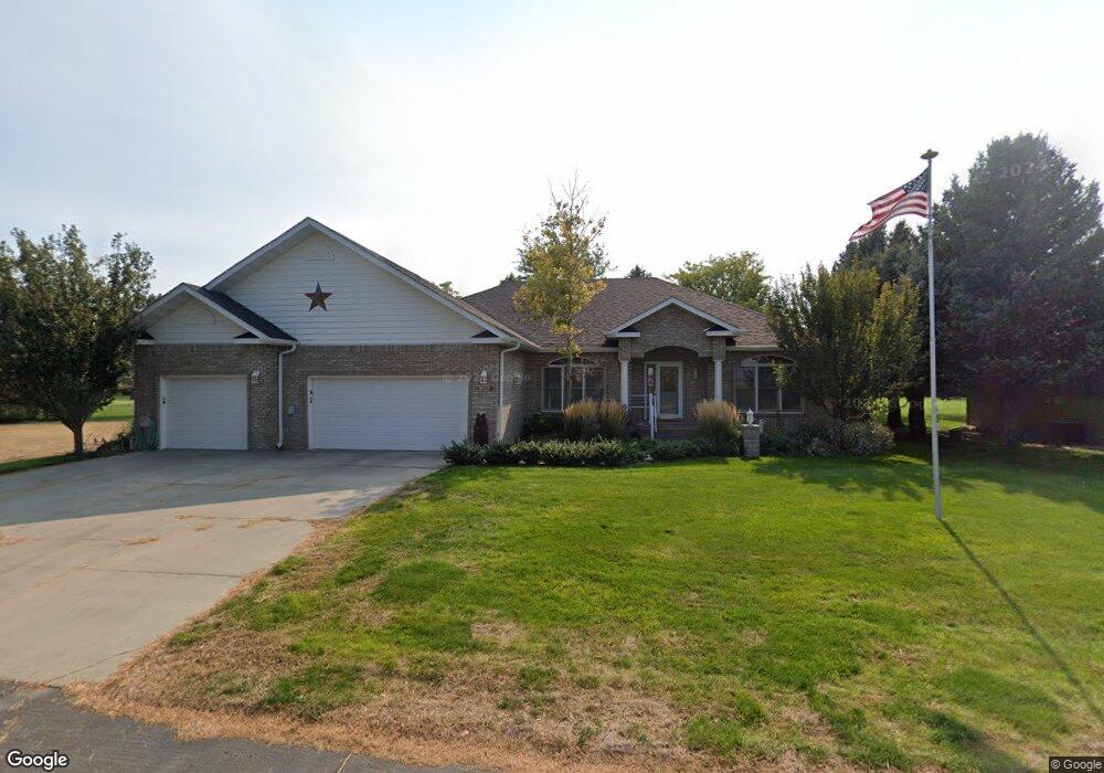
1018 Mockingbird Dr Scottsbluff, NE 69361
Estimated Value: $509,000 - $600,022
3
Beds
3
Baths
2,044
Sq Ft
$273/Sq Ft
Est. Value
About This Home
This home is located at 1018 Mockingbird Dr, Scottsbluff, NE 69361 and is currently estimated at $558,256, approximately $273 per square foot. 1018 Mockingbird Dr is a home located in Scotts Bluff County with nearby schools including Westmoor Elementary School, Bluffs Middle School, and Scottsbluff Senior High School.
Ownership History
Date
Name
Owned For
Owner Type
Purchase Details
Closed on
Dec 5, 2025
Sold by
Amen Carol A and Adams Samuel G
Bought by
Carol A Amen Family Trust and Samuel G Adams Family Trust
Current Estimated Value
Purchase Details
Closed on
Oct 30, 2024
Sold by
Nancy M Gillam Living Trust and Gillam Mark L
Bought by
Amen Carol A and Adams Samuel G
Create a Home Valuation Report for This Property
The Home Valuation Report is an in-depth analysis detailing your home's value as well as a comparison with similar homes in the area
Home Values in the Area
Average Home Value in this Area
Purchase History
| Date | Buyer | Sale Price | Title Company |
|---|---|---|---|
| Carol A Amen Family Trust | -- | None Listed On Document | |
| Amen Carol A | $600,000 | Nebraska Title |
Source: Public Records
Tax History
| Year | Tax Paid | Tax Assessment Tax Assessment Total Assessment is a certain percentage of the fair market value that is determined by local assessors to be the total taxable value of land and additions on the property. | Land | Improvement |
|---|---|---|---|---|
| 2025 | $5,906 | $431,710 | $37,340 | $394,370 |
| 2024 | $5,988 | $431,710 | $37,340 | $394,370 |
| 2023 | $8,476 | $391,033 | $33,327 | $357,706 |
| 2022 | $8,476 | $391,033 | $33,327 | $357,706 |
| 2021 | $8,350 | $380,614 | $33,327 | $347,287 |
| 2020 | $7,797 | $351,939 | $33,327 | $318,612 |
| 2019 | $7,738 | $351,429 | $32,817 | $318,612 |
| 2018 | $7,743 | $351,429 | $32,817 | $318,612 |
| 2017 | $7,735 | $351,429 | $32,817 | $318,612 |
| 2016 | $7,733 | $351,429 | $32,817 | $318,612 |
| 2015 | $7,714 | $351,429 | $32,817 | $318,612 |
| 2014 | $7,207 | $351,429 | $32,817 | $318,612 |
| 2012 | -- | $342,149 | $32,817 | $309,332 |
Source: Public Records
Map
Nearby Homes
- 910 Mockingbird Dr
- 2307 W 42nd St Unit 46
- 3918 Avenue D
- 4501 Cottonwood Ave
- 501 W 38th St
- 1012 W 36th St
- 16 Bluestem
- TBD W 36th St
- 0 W 36th St Unit 20254154
- 2817 W 42nd St
- 60260 Highway 71
- 721 W 33rd St
- 3405 Ross Ave
- 410 Sandra Ct
- 908 E 42nd St
- 3918 Hilltop Estate Place
- TBD U S Highway 26
- Lot 1 31st St
- 1010 W 29th St
- 2809 Avenue I
- 1110 Mockingbird Dr
- 1002 Mockingbird Dr
- 918 Mockingbird Dr
- 1102 Peacock Dr
- 1110 Peacock Dr
- TBD Peacock Dr
- 902 Mockingbird Dr
- 901 Peacock Dr
- 1202 Peacock Dr
- 1214 Mockingbird Dr
- 5414 Cardinal Dr
- 5410 Cardinal Dr
- 5406 Cardinal Dr
- 1210 Peacock Dr
- 905 Flamingo Ct
- 917 Flamingo Ct
- 5402 Cardinal Dr
- 901 Flamingo Ct
- 1010 Mockingbird Dr
- TBD Mockingbird Dr
Your Personal Tour Guide
Ask me questions while you tour the home.