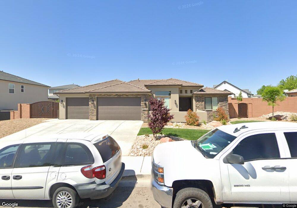
1018 S 1740 E St. George, UT 84790
Estimated Value: $669,858 - $704,000
4
Beds
3
Baths
2,217
Sq Ft
$312/Sq Ft
Est. Value
About This Home
This home is located at 1018 S 1740 E, St. George, UT 84790 and is currently estimated at $691,953, approximately $312 per square foot. 1018 S 1740 E is a home located in Washington County with nearby schools including Heritage School, Dixie Middle School, and Tonaquint Intermediate School.
Ownership History
Date
Name
Owned For
Owner Type
Purchase Details
Closed on
Jul 7, 2020
Sold by
Dvb Constuction Llc
Bought by
Escobedo Hipolito and Escobedo Suilvia
Current Estimated Value
Home Financials for this Owner
Home Financials are based on the most recent Mortgage that was taken out on this home.
Original Mortgage
$375,400
Outstanding Balance
$332,880
Interest Rate
3.1%
Mortgage Type
New Conventional
Estimated Equity
$359,073
Purchase Details
Closed on
Apr 15, 2020
Sold by
Mke Real Estate Llc
Bought by
Dvb Construction Llc
Purchase Details
Closed on
Oct 17, 2018
Sold by
Something Of Worth Inc
Bought by
Mke Real Estate Llc
Home Financials for this Owner
Home Financials are based on the most recent Mortgage that was taken out on this home.
Original Mortgage
$40,000
Interest Rate
4.6%
Mortgage Type
New Conventional
Create a Home Valuation Report for This Property
The Home Valuation Report is an in-depth analysis detailing your home's value as well as a comparison with similar homes in the area
Purchase History
| Date | Buyer | Sale Price | Title Company |
|---|---|---|---|
| Escobedo Hipolito | -- | Infinity Title Ins Agcy Llc | |
| Dvb Construction Llc | -- | Accommodation | |
| Mke Real Estate Llc | -- | Southern Utah Title Co |
Source: Public Records
Mortgage History
| Date | Status | Borrower | Loan Amount |
|---|---|---|---|
| Open | Escobedo Hipolito | $375,400 | |
| Previous Owner | Mke Real Estate Llc | $40,000 |
Source: Public Records
Tax History
| Year | Tax Paid | Tax Assessment Tax Assessment Total Assessment is a certain percentage of the fair market value that is determined by local assessors to be the total taxable value of land and additions on the property. | Land | Improvement |
|---|---|---|---|---|
| 2025 | $2,443 | $364,485 | $110,000 | $254,485 |
| 2023 | $2,398 | $358,325 | $110,000 | $248,325 |
| 2022 | $2,583 | $362,890 | $110,000 | $252,890 |
| 2021 | $2,314 | $484,800 | $110,000 | $374,800 |
| 2020 | $1,013 | $110,000 | $110,000 | $0 |
| 2019 | $1,037 | $110,000 | $110,000 | $0 |
| 2018 | $1,105 | $110,000 | $0 | $0 |
| 2017 | $0 | $0 | $0 | $0 |
Source: Public Records
Map
Nearby Homes
- 994 S 1740 E
- 1031 S 1740 E Unit 3
- 1031 S 1740 E
- 929 S Golda Dr
- 1652 E Howard Ln
- 998 Willow Breeze Ln
- 1006 Willow Breeze Ln
- 0 Riverside Dr Unit 22-238008
- 0 Riverside Dr Unit 1834990
- 805 S River Rd Unit 64
- 805 S River Rd Unit 78
- 805 S River Rd Unit 70
- 0 Knoll
- 1727 Flagstone Rd
- 0 Paisley Way Unit 26-269155
- 0 Paisley Way Unit 24-253758
- 1839 E Boulder Springs Cir
- 0 Tagans Way Unit 24-253754
- 0 Tagans Way Unit 24-253755
- 1186 E 900 S Unit 18
- 0 Southrim at Foremaster Ridge
- 997 S High Mesa Cir
- 1036 S 1740 E
- 1017 S High Mesa Cir
- 1011 S 1740
- 991 S High Mesa Cir
- 1740 E Lot
- 1740 E Lot Unit 3
- Lot 3 1740
- 1052 S 1740 E
- 1035 S High Mesa Cir
- 0 S 1740 E
- 1055 S 1740 E Unit 4
- 1055 S 1740 E
- 1004 S High Mesa Cir
- 1002 S Golda Dr
- 996 S High Mesa Cir
- 973 S 1740 E
- 986 S Golda Dr
- 1024 S Golda Dr
Your Personal Tour Guide
Ask me questions while you tour the home.