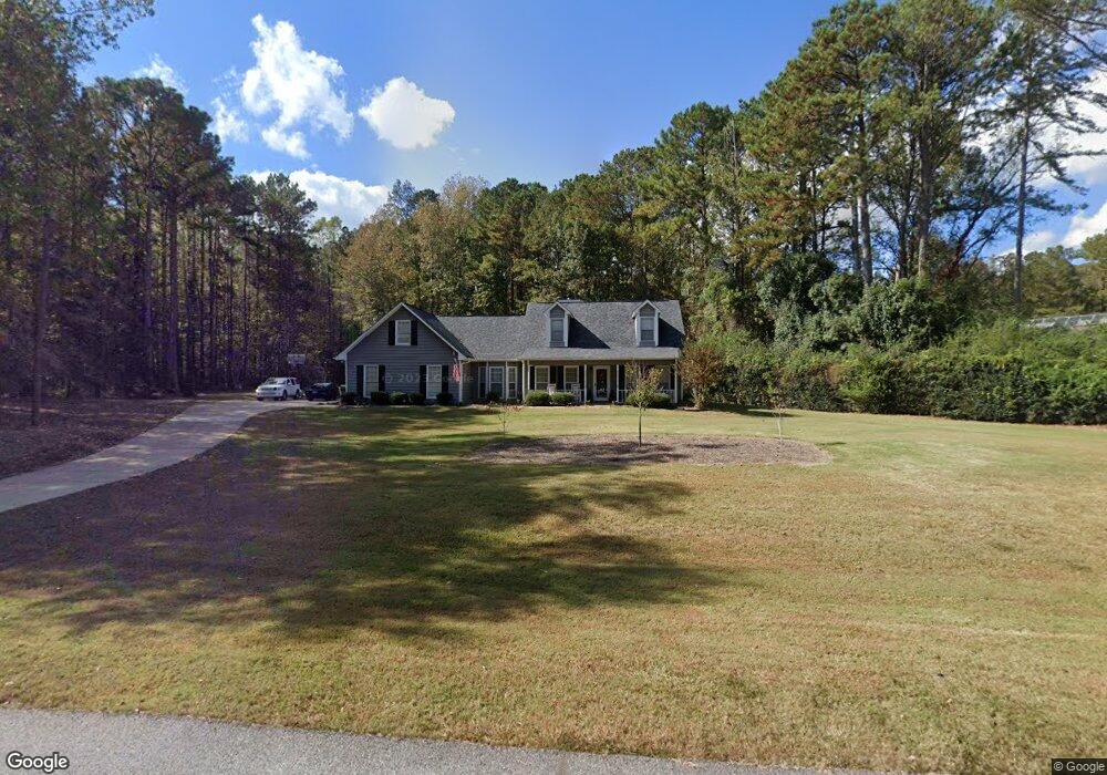
102 Independence Ct Lagrange, GA 30240
Estimated Value: $289,639 - $322,000
3
Beds
4
Baths
2,143
Sq Ft
$144/Sq Ft
Est. Value
About This Home
This home is located at 102 Independence Ct, Lagrange, GA 30240 and is currently estimated at $308,160, approximately $143 per square foot. 102 Independence Ct is a home located in Troup County with nearby schools including Long Cane Elementary School, Berta Weathersbee Elementary School, and Whitesville Road Elementary School.
Ownership History
Date
Name
Owned For
Owner Type
Purchase Details
Closed on
Mar 24, 2000
Sold by
Lisa Thavin and Lisa Emerson
Bought by
Foster Staci C and Foster Claude F
Current Estimated Value
Purchase Details
Closed on
Sep 7, 1994
Sold by
Clowdus G
Bought by
Lisa Thavin and Lisa Emerson
Purchase Details
Closed on
Dec 20, 1990
Sold by
Dan-Ric
Bought by
Clowdus G
Purchase Details
Closed on
Jun 1, 1986
Bought by
Dan-Ric
Create a Home Valuation Report for This Property
The Home Valuation Report is an in-depth analysis detailing your home's value as well as a comparison with similar homes in the area
Purchase History
We collect this data history from publicly available records. To have your information removed, we recommend requesting removal directly through your county’s website.
| Date | Buyer | Sale Price | Title Company |
|---|---|---|---|
| Foster Staci C | $133,200 | -- | |
| Lisa Thavin | $103,500 | -- | |
| Clowdus G | $96,800 | -- | |
| Dan-Ric | $124,500 | -- |
Source: Public Records
Tax History
| Year | Tax Paid | Tax Assessment Tax Assessment Total Assessment is a certain percentage of the fair market value that is determined by local assessors to be the total taxable value of land and additions on the property. | Land | Improvement |
|---|---|---|---|---|
| 2025 | $2,650 | $106,036 | $14,000 | $92,036 |
| 2024 | $2,309 | $86,652 | $14,000 | $72,652 |
| 2023 | $2,395 | $89,820 | $14,000 | $75,820 |
| 2022 | $2,175 | $79,900 | $10,000 | $69,900 |
| 2021 | $2,138 | $72,880 | $10,000 | $62,880 |
| 2020 | $2,138 | $72,880 | $10,000 | $62,880 |
| 2019 | $2,100 | $71,632 | $8,000 | $63,632 |
| 2018 | $2,072 | $70,700 | $8,000 | $62,700 |
| 2017 | $2,072 | $70,700 | $8,000 | $62,700 |
| 2016 | $1,846 | $63,199 | $8,000 | $55,199 |
| 2015 | $1,850 | $63,199 | $8,000 | $55,199 |
| 2014 | $1,760 | $60,132 | $8,000 | $52,132 |
| 2013 | -- | $59,014 | $8,000 | $51,014 |
Source: Public Records
Map
Nearby Homes
- 104 Independence Ct
- 311 Cumberland Dr
- 101 Ivy Springs Dr
- 801 Glass Bridge Rd
- 1054 Glass Bridge Rd
- 6 Hastings Ct
- 474 Newton Rd
- 16 River Point Dr
- 82 Newton Rd
- 1358 Glass Bridge Rd
- 1368 Glass Bridge Rd
- 104 Hidden Springs Dr
- 3658 W Point Rd
- 124 Riverbluff Dr
- 106 Landings Way
- 20 Hill Rd
- 36 Hill Rd
- 101 Riverbluff Dr
- 109 Riverbluff Dr
- 245 Teaver Rd
- 114 Plymouth Dr
- 112 Plymouth Dr
- 107 Independence Ct
- 105 Independence Ct
- 110 Plymouth Dr
- 103 Independence Ct
- 109 Independence Ct
- 101 Independence Ct
- 100 Plymouth Place Unit 93
- 100 Plymouth Place
- 101 Colonial Ct
- 108 Plymouth Dr
- 112 Franklin Place
- 110 Franklin Place
- 191 Courtney Dr Unit 15&16
- 191 Courtney Dr
- 114 Franklin Place
- 101 Plymouth Place
- 176 Courtney Dr
- 103 Colonial Ct
Your Personal Tour Guide
Ask me questions while you tour the home.