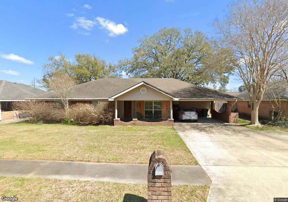
102 Kees Cir Lafayette, LA 70506
Neyland Park NeighborhoodEstimated Value: $198,912 - $278,000
Studio
--
Bath
1,970
Sq Ft
$120/Sq Ft
Est. Value
About This Home
This home is located at 102 Kees Cir, Lafayette, LA 70506 and is currently estimated at $235,728, approximately $119 per square foot. 102 Kees Cir is a home located in Lafayette Parish with nearby schools including Scott Middle School, Lafayette High School, and JCFA Lafayette.
Ownership History
Date
Name
Owned For
Owner Type
Purchase Details
Closed on
Apr 12, 2021
Sold by
Livingston Elizabeth Marie
Bought by
Livingston Anne Catherine
Current Estimated Value
Home Financials for this Owner
Home Financials are based on the most recent Mortgage that was taken out on this home.
Original Mortgage
$86,487
Outstanding Balance
$77,918
Interest Rate
3%
Mortgage Type
FHA
Estimated Equity
$157,810
Create a Home Valuation Report for This Property
The Home Valuation Report is an in-depth analysis detailing your home's value as well as a comparison with similar homes in the area
Home Values in the Area
Average Home Value in this Area
Purchase History
We collect this data history from publicly available records. To have your information removed, we recommend requesting removal directly through your county’s website.
| Date | Buyer | Sale Price | Title Company |
|---|---|---|---|
| Livingston Anne Catherine | $65,000 | None Available |
Source: Public Records
Mortgage History
We collect this data history from publicly available records. To have your information removed, we recommend requesting removal directly through your county’s website.
| Date | Status | Borrower | Loan Amount |
|---|---|---|---|
| Open | Livingston Anne Catherine | $86,487 |
Source: Public Records
Tax History
| Year | Tax Paid | Tax Assessment Tax Assessment Total Assessment is a certain percentage of the fair market value that is determined by local assessors to be the total taxable value of land and additions on the property. | Land | Improvement |
|---|---|---|---|---|
| 2025 | $1,825 | $17,541 | $3,373 | $14,168 |
| 2024 | $1,195 | $17,541 | $3,373 | $14,168 |
| 2023 | $1,195 | $15,909 | $3,373 | $12,536 |
| 2022 | $1,665 | $15,909 | $3,373 | $12,536 |
| 2021 | $1,670 | $15,909 | $3,373 | $12,536 |
| 2020 | $1,665 | $15,909 | $3,373 | $12,536 |
| 2019 | $1,002 | $15,909 | $3,373 | $12,536 |
| 2018 | $1,308 | $15,909 | $3,373 | $12,536 |
| 2017 | $1,306 | $15,910 | $1,800 | $14,110 |
| 2015 | $1,620 | $15,910 | $1,800 | $14,110 |
| 2013 | -- | $15,910 | $1,800 | $14,110 |
Source: Public Records
Map
Nearby Homes
- 1012 Foreman Dr
- 203 Oak Grove Ln
- 200 Oak Grove Ln
- 106 Oak Grove Ln
- 110 Grandmark St
- 106 Grandmark St
- 107 Baltimore Ln
- 817 Omega Dr
- 113 Mesquite St
- 109 Luke Dr
- 202 Federal St
- 108 Poindexter Cir
- 210 San Carlos Cir
- 114 Erika Dr
- 1530 Ambassador Caffery
- 2115 Ambassador Caffery Pkwy
- 2115-2200 Ambassador Caffery Pkwy
- 1314 Dulles Dr Unit A
- 1500 Ambassador Caffery Pkwy
- 2117 Ambassador Caffery Pkwy
Your Personal Tour Guide
Ask me questions while you tour the home.