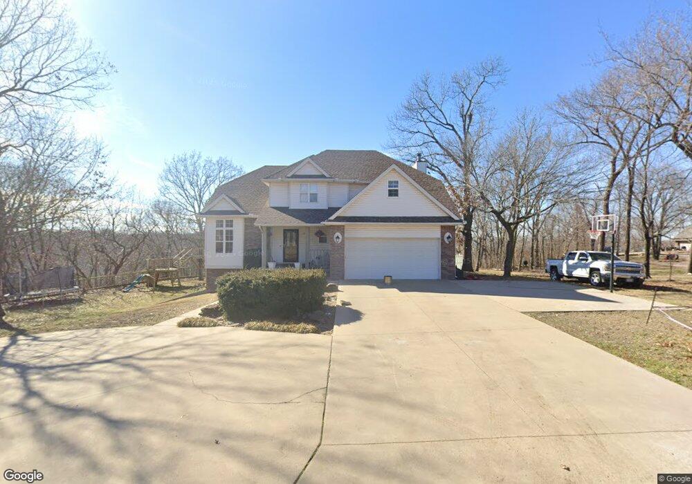
102 Ridge Point Dr Unit 1 Carl Junction, MO 64834
Carl Junction AreaEstimated Value: $429,000 - $536,000
About This Home
This home is located at 102 Ridge Point Dr Unit 1, Carl Junction, MO 64834 and is currently estimated at $488,162, approximately $143 per square foot. 102 Ridge Point Dr Unit 1 is a home located in Jasper County with nearby schools including Carl Junction Primary School (K-1), Carl Junction Intermediate School, and Carl Junction Primary School (2-3).
Ownership History
We collect this data history from publicly available records. To have your information removed, we recommend requesting removal directly through your county’s website.
Purchase Details
Home Financials for this Owner
Home Financials are based on the most recent Mortgage that was taken out on this home.Purchase Details
Home Financials for this Owner
Home Financials are based on the most recent Mortgage that was taken out on this home.Purchase Details
Home Financials for this Owner
Home Financials are based on the most recent Mortgage that was taken out on this home.Purchase Details
Home Financials for this Owner
Home Financials are based on the most recent Mortgage that was taken out on this home.Purchase Details
Home Financials for this Owner
Home Financials are based on the most recent Mortgage that was taken out on this home.Purchase History
We collect this data history from publicly available records. To have your information removed, we recommend requesting removal directly through your county’s website.
| Date | Buyer | Sale Price | Title Company |
|---|---|---|---|
| -- | -- | ||
| -- | None Available | ||
| -- | Alpha Title Llc | ||
| -- | Fatco | ||
| -- | Fatco |
Mortgage History
We collect this data history from publicly available records. To have your information removed, we recommend requesting removal directly through your county’s website.
| Date | Status | Borrower | Loan Amount |
|---|---|---|---|
| Open | $212,000 | ||
| Previous Owner | $251,750 | ||
| Previous Owner | $275,405 | ||
| Previous Owner | $269,325 | ||
| Previous Owner | $145,000 |
Tax History
We collect this data history from publicly available records. To have your information removed, we recommend requesting removal directly through your county’s website.
| Year | Tax Paid | Tax Assessment Tax Assessment Total Assessment is a certain percentage of the fair market value that is determined by local assessors to be the total taxable value of land and additions on the property. | Land | Improvement |
|---|---|---|---|---|
| 2025 | $2,465 | $52,720 | $2,190 | $50,530 |
| 2024 | $2,464 | $48,680 | $2,190 | $46,490 |
| 2023 | $2,464 | $48,680 | $2,190 | $46,490 |
| 2022 | $2,548 | $50,030 | $2,190 | $47,840 |
| 2021 | $2,534 | $50,030 | $2,190 | $47,840 |
| 2020 | $2,368 | $45,960 | $2,190 | $43,770 |
| 2019 | $2,248 | $45,960 | $2,190 | $43,770 |
| 2018 | $1,958 | $40,120 | $0 | $0 |
| 2017 | $1,963 | $40,120 | $0 | $0 |
| 2016 | $2,064 | $42,590 | $0 | $0 |
| 2015 | $2,065 | $42,590 | $0 | $0 |
| 2014 | $2,065 | $42,590 | $0 | $0 |
Map
- 306 Lakeview Ln
- 305 Lakeview Ln
- 407 Lakeview Ln
- 212 Lakeview Ln
- 45 Tanglewood Dr
- 36 Tanglewood Dr
- 132 Black Oak Dr
- 101 Red Oak Loop
- 917 Dogwood Trail Loop
- 3 Tanglewood Dr
- 141 Red Oak Loop
- 318 Tee Ln
- 328 Briarbrook Dr
- 305 Tee Ln
- 6548 Mo-171
- 117 Rocky Ln
- 108 Randolph Dr
- 6648 Geneva Dr
- 202 Briarbrook Dr
- 201 Tee Ln
- TBD Ridge Point Dr
- 102 Ridge Point Dr
- 101 Ridge Point Dr
- 102 Sunset Dr
- 103 Forest Dr
- 104 Sunset Dr
- 303 Sunset Dr
- 107 Forest Dr
- 104 W Forest Dr
- 110 Sunset Dr
- 209 Sunset Dr
- 201 Sunset Dr
- 109 Forest Dr
- 106 Forest Dr
- 104 Red Oak Dr
- 106 Red Oak Dr
- 124 Sunset Loop
- 107 Red Oak Dr
- 107 Red Oak Dr
- 112 Sunset Dr
Ask me questions while you tour the home.