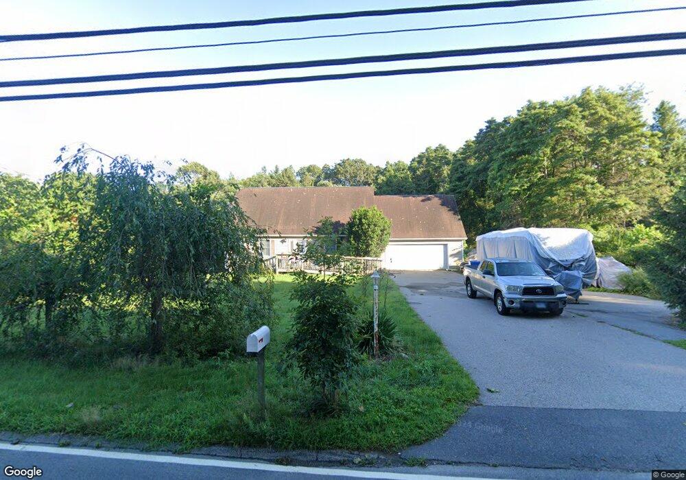
102 Sharp Hill Rd Uncasville, CT 06382
Oxoboxo River NeighborhoodEstimated Value: $385,000 - $455,000
3
Beds
3
Baths
1,798
Sq Ft
$232/Sq Ft
Est. Value
About This Home
This home is located at 102 Sharp Hill Rd, Uncasville, CT 06382 and is currently estimated at $417,879, approximately $232 per square foot. 102 Sharp Hill Rd is a home located in New London County with nearby schools including Leonard J. Tyl Middle School, Montville High School, and Bradley School-New London Regional.
Ownership History
Date
Name
Owned For
Owner Type
Purchase Details
Closed on
May 7, 1997
Sold by
Nacneil Jhn R and Macneil Monica R
Bought by
Fadden David W and Fadden Chong H
Current Estimated Value
Create a Home Valuation Report for This Property
The Home Valuation Report is an in-depth analysis detailing your home's value as well as a comparison with similar homes in the area
Home Values in the Area
Average Home Value in this Area
Purchase History
| Date | Buyer | Sale Price | Title Company |
|---|---|---|---|
| Fadden David W | $150,000 | -- | |
| Fadden David W | $150,000 | -- |
Source: Public Records
Mortgage History
| Date | Status | Borrower | Loan Amount |
|---|---|---|---|
| Open | Fadden David W | $124,000 | |
| Closed | Fadden David W | $50,000 | |
| Closed | Fadden David W | $30,000 |
Source: Public Records
Tax History
| Year | Tax Paid | Tax Assessment Tax Assessment Total Assessment is a certain percentage of the fair market value that is determined by local assessors to be the total taxable value of land and additions on the property. | Land | Improvement |
|---|---|---|---|---|
| 2025 | $5,929 | $205,380 | $31,500 | $173,880 |
| 2024 | $5,703 | $205,380 | $31,500 | $173,880 |
| 2023 | $5,703 | $205,380 | $31,500 | $173,880 |
| 2022 | $5,486 | $205,380 | $31,500 | $173,880 |
| 2021 | $5,212 | $164,160 | $34,790 | $129,370 |
| 2020 | $5,316 | $164,160 | $34,790 | $129,370 |
| 2019 | $5,337 | $164,160 | $34,790 | $129,370 |
| 2018 | $5,209 | $164,160 | $34,780 | $129,380 |
| 2017 | $5,204 | $164,160 | $34,780 | $129,380 |
| 2016 | $5,354 | $174,900 | $43,480 | $131,420 |
| 2015 | $5,354 | $174,900 | $43,480 | $131,420 |
| 2014 | $5,101 | $173,670 | $43,480 | $130,190 |
Source: Public Records
Map
Nearby Homes
- 16 Carol Dr
- 40 Carol Dr
- 571 Old Colchester Rd
- 10 Sharp Hill Rd
- 320 Maple Ave
- 505 Old Colchester Rd
- 76 Gay Hill Rd
- 79 Cottonwood Ln
- 25 Heather Brook Rd
- 2 Fawns Meadow Rd
- 82C Pires Dr
- 4 Greystone Dr
- 950 Old Colchester Rd
- 16 Greystone Dr
- 567 Fire St
- 11 Mayo Ave
- 5 Blumenthal Dr
- 107 Woodland Dr Unit B
- 27 Allen Dr Unit A
- 455 Chesterfield Rd
- 112 Sharp Hill Rd
- 98 Sharp Hill Rd
- 116 Sharp Hill Rd
- 106 Sharp Hill Rd
- 109 Sharp Hill Rd
- 99 Sharp Hill Rd
- 95 Sharp Hill Rd
- 113 Sharp Hill Rd
- 100 Sharp Hill Rd
- 119 Sharp Hill Rd
- 47 Sharp Hill Rd
- 4 Carol Dr
- 90 Sharp Hill Rd
- 128 Sharp Hill Rd
- 82 Sharp Hill Rd
- 12 Carol Dr
- 8 Carol Dr
- 68 Sharp Hill Rd
- 12 Elton Ct
- 131 Sharp Hill Rd
Your Personal Tour Guide
Ask me questions while you tour the home.