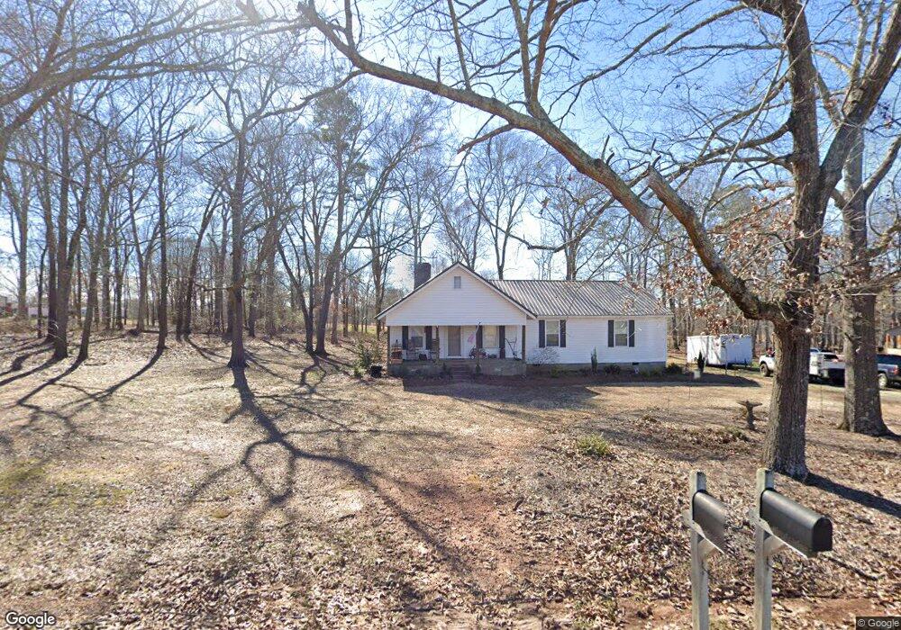
1024 Firetower Rd Honea Path, SC 29654
Estimated Value: $147,582 - $271,000
Studio
--
Bath
1,779
Sq Ft
$120/Sq Ft
Est. Value
About This Home
This home is located at 1024 Firetower Rd, Honea Path, SC 29654 and is currently estimated at $213,646, approximately $120 per square foot. 1024 Firetower Rd is a home with nearby schools including Belton Honea Path High School and Whispering Pines Mennonite School.
Ownership History
Date
Name
Owned For
Owner Type
Purchase Details
Closed on
Jun 14, 2015
Sold by
Neely John R and Neely Patricia E
Bought by
Gunnells Ronnie Dale
Current Estimated Value
Home Financials for this Owner
Home Financials are based on the most recent Mortgage that was taken out on this home.
Original Mortgage
$40,000
Interest Rate
3.88%
Mortgage Type
New Conventional
Purchase Details
Closed on
Jun 16, 2008
Sold by
Carolinas Telco Fcu
Bought by
Neely John R and Neely Patricia E
Purchase Details
Closed on
Feb 16, 2007
Sold by
Zegalia Brenda
Bought by
Carolinas Telco Fcu
Create a Home Valuation Report for This Property
The Home Valuation Report is an in-depth analysis detailing your home's value as well as a comparison with similar homes in the area
Home Values in the Area
Average Home Value in this Area
Purchase History
| Date | Buyer | Sale Price | Title Company |
|---|---|---|---|
| Gunnells Ronnie Dale | $20,000 | -- | |
| Neely John R | $20,500 | -- | |
| Carolinas Telco Fcu | -- | None Available |
Source: Public Records
Mortgage History
| Date | Status | Borrower | Loan Amount |
|---|---|---|---|
| Closed | Gunnells Ronnie Dale | $40,000 |
Source: Public Records
Tax History
| Year | Tax Paid | Tax Assessment Tax Assessment Total Assessment is a certain percentage of the fair market value that is determined by local assessors to be the total taxable value of land and additions on the property. | Land | Improvement |
|---|---|---|---|---|
| 2024 | $1,406 | $4,900 | $2,100 | $2,800 |
| 2023 | $1,372 | $4,900 | $2,100 | $2,800 |
| 2022 | $1,306 | $4,900 | $2,100 | $2,800 |
| 2021 | $1,269 | $3,410 | $680 | $2,730 |
| 2020 | $1,253 | $3,410 | $680 | $2,730 |
| 2019 | $1,253 | $3,410 | $680 | $2,730 |
| 2018 | $1,260 | $3,410 | $680 | $2,730 |
| 2017 | -- | $1,940 | $680 | $1,260 |
| 2016 | $849 | $2,250 | $780 | $1,470 |
| 2015 | $872 | $2,250 | $780 | $1,470 |
| 2014 | $862 | $2,250 | $780 | $1,470 |
Source: Public Records
Map
Nearby Homes
- 229 Armstrong Rd
- 310 Oak Dr
- 701 W Greer St
- 1411 Trail Rd
- 11306 Belton Honea Path Hwy
- 11919 Belton Honea Path Hwy
- 107 Brookside Cir
- 220 Bill Kay Rd
- 7 Carlisle Dr
- 104 Albert Dr
- 00 Ellison Rd
- 704 Sherwood Ave
- 417 N Main St
- 00 Brook St
- 511 N Main St
- 600 N Main St
- 00 Ervin St
- 5 George St
- 1 E McGee St
- 520 Elizabeth Street Extension
- 2 Griffin Farm Rd
- 0 Griffin Farm Rd
- 000 Griffin Farm Rd
- 00 Griffin Farm Rd
- 00 Griffin Farm Rd Unit Jim Buddy Road
- 952 Firetower Rd
- 1003 Firetower Rd
- 10 Griffin Farm Rd
- 5 Griffin Farm Rd
- 12 Griffin Farm Rd
- 1108 Firetower Rd
- 13 Griffin Farm Rd
- 17 Griffin Farm Rd
- 19 Griffin Farm Rd
- 926 Firetower Rd
- 3133 Highway 252
- 32 Griffin Farm Rd
- 3129 Highway 252
- 100 Branyon Cir
- 3214 Highway 252
Your Personal Tour Guide
Ask me questions while you tour the home.