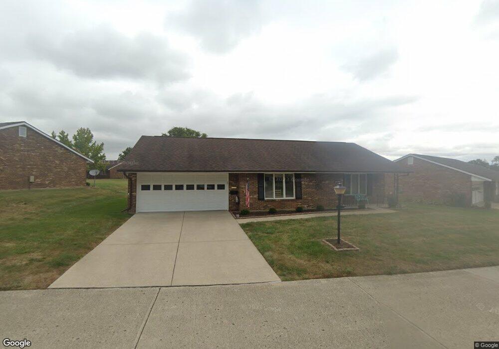
1030 Armsgate Rd Springfield, OH 45503
Estimated Value: $194,000 - $202,000
2
Beds
2
Baths
1,300
Sq Ft
$152/Sq Ft
Est. Value
About This Home
This home is located at 1030 Armsgate Rd, Springfield, OH 45503 and is currently estimated at $198,034, approximately $152 per square foot. 1030 Armsgate Rd is a home located in Clark County with nearby schools including Northridge Elementary School, Kenton Ridge Middle & High School, and Emmanuel Christian Academy.
Ownership History
Date
Name
Owned For
Owner Type
Purchase Details
Closed on
Jul 20, 2011
Sold by
Calvert Bernice M
Bought by
Riley Larry O and Riley Karen K
Current Estimated Value
Purchase Details
Closed on
Sep 18, 2006
Sold by
Shiddenhelm Eleanor F
Bought by
Calvert Bernice M
Purchase Details
Closed on
Dec 17, 1992
Sold by
Shiddenhelm Eleanor F
Bought by
Shiddenhelm Eleanor F Trustee
Purchase Details
Closed on
Oct 5, 1989
Create a Home Valuation Report for This Property
The Home Valuation Report is an in-depth analysis detailing your home's value as well as a comparison with similar homes in the area
Home Values in the Area
Average Home Value in this Area
Purchase History
| Date | Buyer | Sale Price | Title Company |
|---|---|---|---|
| Riley Larry O | $81,000 | Attorney | |
| Calvert Bernice M | $115,000 | None Available | |
| Shiddenhelm Eleanor F Trustee | -- | -- | |
| -- | -- | -- |
Source: Public Records
Tax History
| Year | Tax Paid | Tax Assessment Tax Assessment Total Assessment is a certain percentage of the fair market value that is determined by local assessors to be the total taxable value of land and additions on the property. | Land | Improvement |
|---|---|---|---|---|
| 2025 | $1,246 | $53,260 | $7,350 | $45,910 |
| 2024 | $1,230 | $39,170 | $6,300 | $32,870 |
| 2023 | $1,230 | $39,170 | $6,300 | $32,870 |
| 2022 | $1,252 | $39,170 | $6,300 | $32,870 |
| 2021 | $1,423 | $38,300 | $5,250 | $33,050 |
| 2020 | $1,425 | $38,300 | $5,250 | $33,050 |
| 2019 | $1,453 | $38,300 | $5,250 | $33,050 |
| 2018 | $1,123 | $30,910 | $5,570 | $25,340 |
| 2017 | $954 | $30,244 | $5,565 | $24,679 |
| 2016 | $947 | $30,244 | $5,565 | $24,679 |
| 2015 | $847 | $29,929 | $5,250 | $24,679 |
| 2014 | $847 | $29,929 | $5,250 | $24,679 |
| 2013 | $845 | $29,929 | $5,250 | $24,679 |
Source: Public Records
Map
Nearby Homes
- 1039 Bradford Dr Unit 42
- 1139 Bradford Dr
- 3052 Brixton Dr E
- 1136 Foxboro Rd Unit 202
- 3124 El Camino Dr
- 1525 Providence Ave
- 3135 Imperial Blvd
- 1404 Attleboro Ave
- 2943 Tarryton Ln
- 732 Grandview Dr Unit 732
- 2022 Westboro Ave
- 3214 Revels St
- 1201 Kingsgate Rd
- 3631 Kingsgate Ln
- 1162 Kingsgate Rd
- 1500 Kingsgate Rd Unit 19430
- 1502 Kingsgate Rd Unit 19432
- 1500 Kingsgate Rd
- 1502 Kingsgate Rd
- 1507 Kingsgate Rd
- 1030 Armsgate Rd Unit 29
- 1026 Armsgate Rd
- 1029 Armsgate Rd Unit 12
- 1031 Armsgate Rd Unit 11
- 1027 Armsgate Rd Unit 13
- 1027 Armsgate Rd Unit VILLA
- 1034 Armsgate Rd
- 3028 Armsgate Rd
- 3028 Armsgate Rd
- 1033 Bradford Dr Unit 45
- 1033 Armsgate Rd
- 1025 Armsgate Rd
- 1035 Armsgate Rd Unit 9
- 3027 Armsgate Rd
- 1036 Armsgate Rd
- 3030 Armsgate Rd Unit 26
- 1037 Bradford Dr Unit 43
- 1037 Armsgate Rd
- 1034 Bradford Dr
- 1034 Bradford Dr Unit 53
Your Personal Tour Guide
Ask me questions while you tour the home.