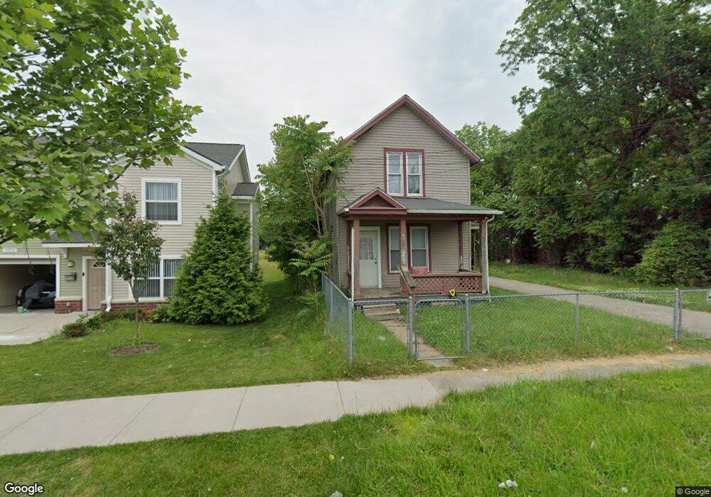
1031 Root St Flint, MI 48503
Downtown Flint NeighborhoodEstimated Value: $68,000 - $135,000
Studio
1
Bath
1,508
Sq Ft
$64/Sq Ft
Est. Value
About This Home
This home is located at 1031 Root St, Flint, MI 48503 and is currently estimated at $96,892, approximately $64 per square foot. 1031 Root St is a home located in Genesee County with nearby schools including Doyle/Ryder School, Flint Cultural Center Academy, and WAY Academy of Flint.
Ownership History
Date
Name
Owned For
Owner Type
Purchase Details
Closed on
Jul 18, 2019
Sold by
Speace Benny
Bought by
Heros April and Woods Kabior
Current Estimated Value
Purchase Details
Closed on
Aug 30, 2018
Sold by
Thomas Corie L
Bought by
Spence Benny
Purchase Details
Closed on
Apr 10, 2017
Sold by
Spence Benny
Bought by
Spence Benny and Harris April M
Purchase Details
Closed on
Mar 24, 2004
Sold by
Spence Benny and Estate Of Viola Goza Hudson
Bought by
Spence Benny
Create a Home Valuation Report for This Property
The Home Valuation Report is an in-depth analysis detailing your home's value as well as a comparison with similar homes in the area
Home Values in the Area
Average Home Value in this Area
Purchase History
| Date | Buyer | Sale Price | Title Company |
|---|---|---|---|
| Heros April | -- | None Available | |
| Spence Benny | -- | None Available | |
| Spence Benny | -- | None Available | |
| Spence Benny | -- | -- |
Source: Public Records
Tax History
| Year | Tax Paid | Tax Assessment Tax Assessment Total Assessment is a certain percentage of the fair market value that is determined by local assessors to be the total taxable value of land and additions on the property. | Land | Improvement |
|---|---|---|---|---|
| 2025 | $729 | $11,700 | $0 | $0 |
| 2024 | $685 | $9,900 | $0 | $0 |
| 2023 | $677 | $9,100 | $0 | $0 |
| 2022 | $0 | $10,500 | $0 | $0 |
| 2021 | $681 | $9,800 | $0 | $0 |
| 2020 | $637 | $7,200 | $0 | $0 |
| 2019 | $847 | $5,600 | $0 | $0 |
| 2018 | $1,649 | $4,700 | $0 | $0 |
| 2017 | $851 | $0 | $0 | $0 |
| 2016 | $442 | $0 | $0 | $0 |
| 2015 | -- | $0 | $0 | $0 |
| 2014 | -- | $0 | $0 | $0 |
| 2012 | -- | $4,400 | $0 | $0 |
Source: Public Records
Map
Nearby Homes
- 562 Williams St
- 1303 Root St
- 416 W 2nd Ave Unit 4
- 407 W 2nd Ave
- 800 Martin Luther King Ave
- 1606 Garland St
- 1710 Wilberforce Cir
- 1706 Wilberforce Cir
- 122 Welch Blvd
- 1620 Mason St
- 1409 Prospect St
- 626 E 2nd St
- 1239 Poplar St
- 621 Pierson St
- 1645 Seminole St
- 1241 Poplar St
- 2217 Francis Ave
- 314 E 4th St
- 410 E 4th St
- 712 S Grand Traverse St
Your Personal Tour Guide
Ask me questions while you tour the home.