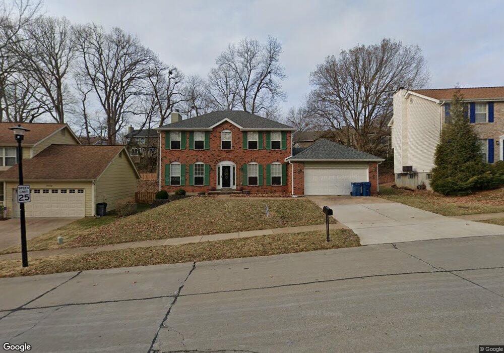
1036 Westrun Dr Ballwin, MO 63021
Estimated Value: $416,962 - $512,000
About This Home
This home is located at 1036 Westrun Dr, Ballwin, MO 63021 and is currently estimated at $464,491, approximately $206 per square foot. 1036 Westrun Dr is a home located in St. Louis County with nearby schools including Woerther Elementary School, Selvidge Middle School, and Marquette Sr. High School.
Ownership History
We collect this data history from publicly available records. To have your information removed, we recommend requesting removal directly through your county’s website.
Purchase Details
Home Financials for this Owner
Home Financials are based on the most recent Mortgage that was taken out on this home.Purchase Details
Home Financials for this Owner
Home Financials are based on the most recent Mortgage that was taken out on this home.Purchase Details
Home Financials for this Owner
Home Financials are based on the most recent Mortgage that was taken out on this home.Home Values in the Area
Average Home Value in this Area
Purchase History
We collect this data history from publicly available records. To have your information removed, we recommend requesting removal directly through your county’s website.
| Date | Buyer | Sale Price | Title Company |
|---|---|---|---|
| -- | Title Partners Agency Llc | ||
| $215,000 | Investors Title Co Clayton | ||
| -- | -- |
Mortgage History
We collect this data history from publicly available records. To have your information removed, we recommend requesting removal directly through your county’s website.
| Date | Status | Borrower | Loan Amount |
|---|---|---|---|
| Open | $240,800 | ||
| Closed | $193,500 | ||
| Previous Owner | $123,900 |
Tax History
We collect this data history from publicly available records. To have your information removed, we recommend requesting removal directly through your county’s website.
| Year | Tax Paid | Tax Assessment Tax Assessment Total Assessment is a certain percentage of the fair market value that is determined by local assessors to be the total taxable value of land and additions on the property. | Land | Improvement |
|---|---|---|---|---|
| 2025 | $4,454 | $65,720 | $28,080 | $37,640 |
| 2024 | $4,454 | $63,650 | $15,580 | $48,070 |
| 2023 | $4,450 | $63,650 | $15,580 | $48,070 |
| 2022 | $4,092 | $54,330 | $18,720 | $35,610 |
| 2021 | $4,062 | $54,330 | $18,720 | $35,610 |
| 2020 | $4,090 | $52,160 | $18,720 | $33,440 |
| 2019 | $4,107 | $52,160 | $18,720 | $33,440 |
| 2018 | $3,363 | $40,220 | $14,040 | $26,180 |
| 2017 | $3,283 | $40,220 | $14,040 | $26,180 |
| 2016 | $3,576 | $42,160 | $14,040 | $28,120 |
| 2015 | $3,504 | $42,160 | $14,040 | $28,120 |
| 2014 | $3,817 | $44,820 | $11,740 | $33,080 |
Map
- 884 Village Brook Ct
- 330 Woodlawn Terrace Ct
- 305 Oak Top Ct
- 20 Greystoke Ct
- 331 Woodlawn Terrace Ct
- 329 Gateford Dr
- 1348 Richland Meadows Dr
- 1342 Oak Borough Dr
- 340 Fox Village Ct
- 245 Reinke Rd
- 835 Westrun Dr
- 254 Village Mead Dr
- 426 Buckhurst Dr
- 589 Wetherby Terrace Dr
- 751 Trago Creek Dr
- 248 Village Creek Dr
- 218 Aspen Village Dr
- 573 Castle Ridge Dr
- 1566 Buckhurst Ct
- 716 Reinke Rd
- 1032 Westrun Dr
- 1040 Westrun Dr
- 422 Alverston Ct
- 1028 Westrun Dr
- 426 Alverston Ct
- 414 Alverston Ct
- 1044 Westrun Dr
- 430 Alverston Ct
- 1024 Westrun Dr
- 410 Alverston Ct
- 336 Alverston Ct
- 332 Alverston Ct
- 340 Alverston Ct
- 344 Alverston Ct
- 1101 Richland Meadows Dr
- 402 Alverston Ct
- 434 Alverston Ct
- 1020 Westrun Dr
- 328 Alverston Ct
- 1107 Richland Meadows Dr
Ask me questions while you tour the home.