Estimated Value: $281,000 - $309,972
3
Beds
2
Baths
1,400
Sq Ft
$211/Sq Ft
Est. Value
About This Home
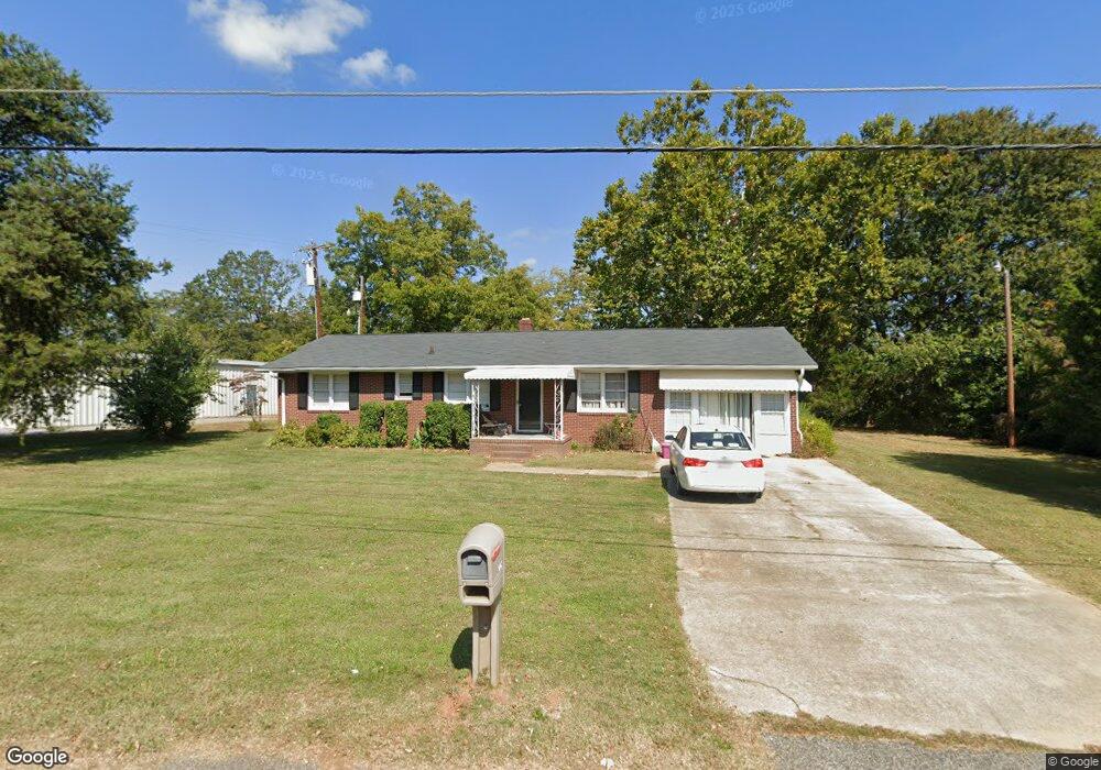
This home is located at 104 West Rd, Greer, SC 29650 and is currently estimated at $295,243, approximately $210 per square foot. 104 West Rd is a home located in Greenville County with nearby schools including Woodland Elementary School, Greer Middle School, and Greer High School.
Ownership History
Date
Name
Owned For
Owner Type
Purchase Details
Closed on
Sep 19, 2024
Sold by
Log Cabin Enterprises Llc
Bought by
Sycamore West Llc
Current Estimated Value
Purchase Details
Closed on
Aug 6, 2008
Sold by
Arrowood Lisa Smith
Bought by
Log Cabin Enterprises Inc
Home Financials for this Owner
Home Financials are based on the most recent Mortgage that was taken out on this home.
Original Mortgage
$93,750
Interest Rate
6.31%
Mortgage Type
Commercial
Purchase Details
Closed on
Jul 27, 2008
Sold by
Garber Dorrie Smith
Bought by
Log Cabin Enterprises Inc
Home Financials for this Owner
Home Financials are based on the most recent Mortgage that was taken out on this home.
Original Mortgage
$93,750
Interest Rate
6.31%
Mortgage Type
Commercial
Purchase Details
Closed on
Aug 14, 2003
Sold by
Smith William Marvin
Bought by
Smith Sarah Elizabeth
Purchase Details
Closed on
Sep 14, 1998
Sold by
Smith William M
Bought by
S C Hwy Dept
Create a Home Valuation Report for This Property
The Home Valuation Report is an in-depth analysis detailing your home's value as well as a comparison with similar homes in the area
Home Values in the Area
Average Home Value in this Area
Purchase History
We collect this data history from publicly available records. To have your information removed, we recommend requesting removal directly through your county’s website.
| Date | Buyer | Sale Price | Title Company |
|---|---|---|---|
| Sycamore West Llc | $350,000 | None Listed On Document | |
| Log Cabin Enterprises Inc | $135,000 | -- | |
| Log Cabin Enterprises Inc | $135,000 | -- | |
| Smith Sarah Elizabeth | -- | -- | |
| S C Hwy Dept | $1,350 | -- |
Source: Public Records
Mortgage History
We collect this data history from publicly available records. To have your information removed, we recommend requesting removal directly through your county’s website.
| Date | Status | Borrower | Loan Amount |
|---|---|---|---|
| Previous Owner | Log Cabin Enterprises Inc | $93,750 |
Source: Public Records
Tax History
| Year | Tax Paid | Tax Assessment Tax Assessment Total Assessment is a certain percentage of the fair market value that is determined by local assessors to be the total taxable value of land and additions on the property. | Land | Improvement |
|---|---|---|---|---|
| 2025 | $5,490 | $19,930 | $3,350 | $16,580 |
| 2024 | $5,490 | $8,300 | $1,720 | $6,580 |
| 2023 | $2,523 | $8,300 | $1,720 | $6,580 |
| 2022 | $2,398 | $8,300 | $1,720 | $6,580 |
| 2021 | $2,361 | $8,300 | $1,720 | $6,580 |
| 2020 | $2,379 | $7,950 | $1,720 | $6,230 |
| 2019 | $2,380 | $7,950 | $1,720 | $6,230 |
| 2018 | $2,329 | $7,950 | $1,720 | $6,230 |
| 2017 | $2,289 | $7,950 | $1,720 | $6,230 |
| 2016 | $2,219 | $132,510 | $28,600 | $103,910 |
| 2015 | $2,219 | $132,510 | $28,600 | $103,910 |
| 2014 | $2,259 | $136,430 | $28,600 | $107,830 |
Source: Public Records
Map
Nearby Homes
- 7 Country Dale Dr
- 130 Marthawood Ln
- 912 S Main St
- 213 Juniper Leaf Way
- 215 Juniper Leaf Way
- 221 Juniper Leaf Way
- 329 Juniper Leaf Way
- 209 Springdale Ave
- 211 Buncombe St
- 00 Circle Dr
- 111 Madison Ave
- 104 Snow St
- 117 Benjamin Ave
- 125 Circle Dr
- 123 Circle Dr
- 00 Carey Ave
- 0 Carey Ave
- 106 Oak Forest Dr
- 107 Coogan Ln
- 215 Wrightwood Ln
- 33 Country Dale Dr
- 33 Country Dale Dr Unit 1305C
- 31 Country Dale Dr Unit 1305B
- 31 Country Dale Dr
- 29 Country Dale Dr
- 29 Country Dale Dr Unit 1305A
- 25 Country Dale Dr
- 25 Country Dale Dr Unit 1303B
- 404 Teresa Gem Ln Unit 1307C
- 404 Teresa Gem Ln
- 406 Teresa Gem Ln
- 1307C Teresa Gem Ln Unit 1307C
- 402 Teresa Gem Ln Unit 1307D
- 408 Teresa Gem Ln
- 400 Teresa Gem Ln
- 400 Teresa Gem Ln Unit 1307E End Unit
- 23 Country Dale Dr
- 34 Country Dale Dr
- 101 Marthawood Ln
- 30 Country Dale Dr
Your Personal Tour Guide
Ask me questions while you tour the home.