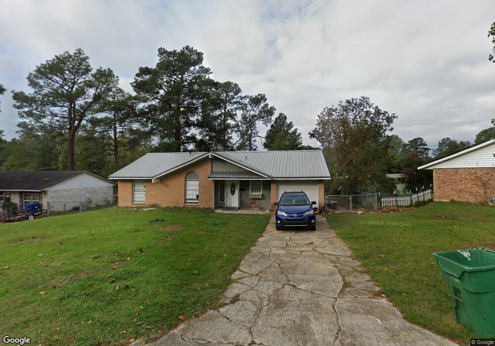
1040 Anderson Dr Leesville, LA 71446
Estimated Value: $74,000 - $101,000
3
Beds
2
Baths
1,819
Sq Ft
$48/Sq Ft
Est. Value
About This Home
This home is located at 1040 Anderson Dr, Leesville, LA 71446 and is currently estimated at $86,786, approximately $47 per square foot. 1040 Anderson Dr is a home located in Vernon Parish with nearby schools including Faith Training Christian Academy Elementary, Faith Training Christian Academy, and Faith Training Christian Academy High School.
Ownership History
Date
Name
Owned For
Owner Type
Purchase Details
Closed on
Jul 9, 2021
Sold by
Clark Laura J Est
Bought by
J & M Enterprises
Current Estimated Value
Purchase Details
Closed on
Oct 2, 2009
Sold by
Goldsworthy David W
Bought by
Clark Patrick Westley and Clark Laura Jean Batiste
Home Financials for this Owner
Home Financials are based on the most recent Mortgage that was taken out on this home.
Original Mortgage
$65,000
Interest Rate
5.1%
Mortgage Type
Purchase Money Mortgage
Create a Home Valuation Report for This Property
The Home Valuation Report is an in-depth analysis detailing your home's value as well as a comparison with similar homes in the area
Home Values in the Area
Average Home Value in this Area
Purchase History
| Date | Buyer | Sale Price | Title Company |
|---|---|---|---|
| J & M Enterprises | $69,000 | None Available | |
| Clark Patrick Westley | $65,000 | -- |
Source: Public Records
Mortgage History
| Date | Status | Borrower | Loan Amount |
|---|---|---|---|
| Previous Owner | Clark Patrick Westley | $65,000 |
Source: Public Records
Tax History
| Year | Tax Paid | Tax Assessment Tax Assessment Total Assessment is a certain percentage of the fair market value that is determined by local assessors to be the total taxable value of land and additions on the property. | Land | Improvement |
|---|---|---|---|---|
| 2025 | $621 | $6,280 | $500 | $5,780 |
| 2024 | $739 | $6,280 | $500 | $5,780 |
| 2023 | $737 | $6,280 | $500 | $5,780 |
| 2022 | $724 | $6,280 | $500 | $5,780 |
| 2021 | $771 | $6,280 | $500 | $5,780 |
| 2020 | $641 | $5,070 | $570 | $4,500 |
| 2019 | $661 | $5,070 | $570 | $4,500 |
| 2018 | $659 | $5,070 | $570 | $4,500 |
| 2017 | $658 | $5,070 | $570 | $4,500 |
| 2015 | $643 | $5,070 | $570 | $4,500 |
| 2014 | $575 | $5,070 | $570 | $4,500 |
| 2013 | $682 | $5,070 | $570 | $4,500 |
Source: Public Records
Map
Nearby Homes
- 1058 Westwood Dr
- 922 Kings Rd
- 917 Kings Rd
- 915 Kings Rd
- 1301 Oak Dr
- 1104 Anderson Dr
- 901 Kings Rd
- 1111 Anderson Dr
- 912 Dennis Ave
- 1314 Oak Dr
- 1015 Anderson Dr
- 1007 Dennis Ave
- 1009 Anderson Dr
- 1122 Anderson Dr
- 1005 Anderson Dr
- 801 Kings Rd
- 1100 Westwood Dr
- 1100 Aaron St
- 1000 John Paul Jones Ave
- 2112 Jean St
- 1042 Anderson Dr
- 1038 Anderson Dr
- 1044 Anderson Dr
- 1047 Anderson Dr
- 1049 Anderson Dr
- 1035 Hood Ln
- 1051 Westwood Dr
- 1051 Westwood Dr Unit Drive
- 1036 Anderson Dr
- 1049 Westwood Dr
- 1049 Westwood Dr Unit Dr
- 1046 Anderson Dr
- 1045 Anderson Dr
- 1034 Hood Ln
- 1043 Anderson Dr
- 1047 Westwood Dr
- 1055 Westwood Dr
- 1053 Anderson Dr
- 1034 Anderson Dr
- 1041 Anderson Dr
Your Personal Tour Guide
Ask me questions while you tour the home.