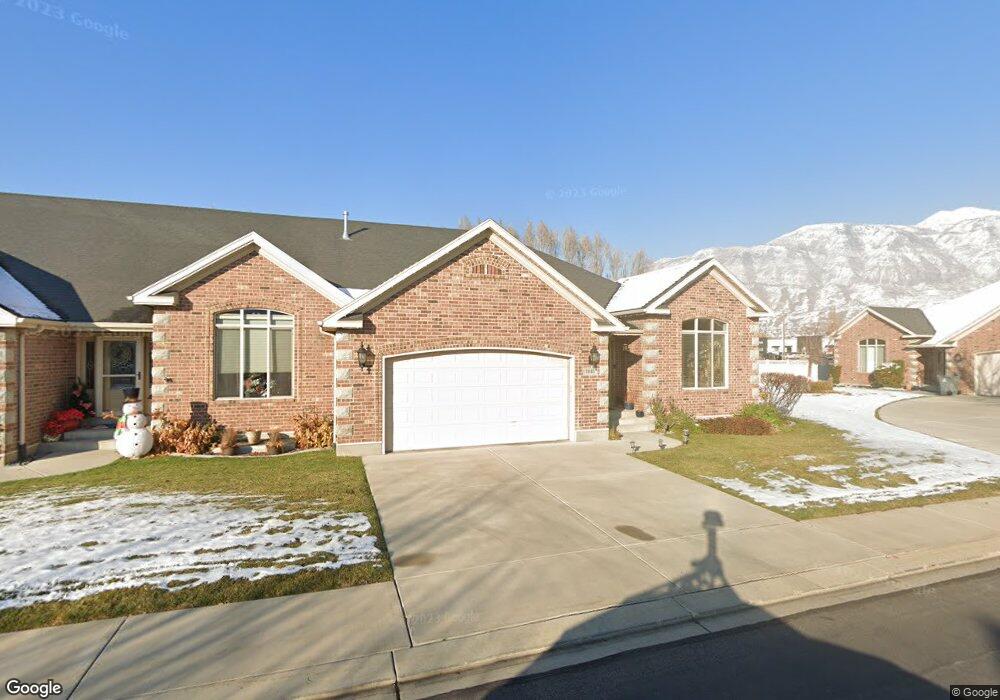
1041 E 150 S American Fork, UT 84003
Estimated Value: $538,000 - $584,000
3
Beds
3
Baths
3,240
Sq Ft
$172/Sq Ft
Est. Value
About This Home
This home is located at 1041 E 150 S, American Fork, UT 84003 and is currently estimated at $558,686, approximately $172 per square foot. 1041 E 150 S is a home located in Utah County with nearby schools including Barratt Elementary School, American Fork Junior High School, and American Fork High School.
Ownership History
Date
Name
Owned For
Owner Type
Purchase Details
Closed on
Feb 22, 2016
Sold by
Wager Stephen Mark and Hosteter Frances Wager
Bought by
Kewish Lavelle Ridd Moss
Current Estimated Value
Home Financials for this Owner
Home Financials are based on the most recent Mortgage that was taken out on this home.
Original Mortgage
$100,000
Outstanding Balance
$42,825
Interest Rate
3.81%
Mortgage Type
New Conventional
Estimated Equity
$515,861
Purchase Details
Closed on
Aug 12, 2015
Sold by
Wager Merlin Clark and Clark Wager M
Bought by
Wager Stephen Mark and Hostetter Frances Wager
Purchase Details
Closed on
Sep 30, 2005
Sold by
Pristine Developers Inc
Bought by
Wager M Clark and Wager Kathryn
Create a Home Valuation Report for This Property
The Home Valuation Report is an in-depth analysis detailing your home's value as well as a comparison with similar homes in the area
Home Values in the Area
Average Home Value in this Area
Purchase History
| Date | Buyer | Sale Price | Title Company |
|---|---|---|---|
| Kewish Lavelle Ridd Moss | -- | Meridian Title Co | |
| Wager Stephen Mark | -- | None Available | |
| Wager M Clark | -- | Mountain West Title Company |
Source: Public Records
Mortgage History
| Date | Status | Borrower | Loan Amount |
|---|---|---|---|
| Open | Kewish Lavelle Ridd Moss | $100,000 |
Source: Public Records
Tax History
| Year | Tax Paid | Tax Assessment Tax Assessment Total Assessment is a certain percentage of the fair market value that is determined by local assessors to be the total taxable value of land and additions on the property. | Land | Improvement |
|---|---|---|---|---|
| 2025 | $2,631 | $290,950 | -- | -- |
| 2024 | $2,631 | $292,380 | $0 | $0 |
| 2023 | $2,386 | $281,105 | $0 | $0 |
| 2022 | $2,472 | $287,320 | $0 | $0 |
| 2021 | $2,026 | $367,800 | $55,200 | $312,600 |
| 2020 | $1,982 | $349,100 | $52,400 | $296,700 |
| 2019 | $1,917 | $349,100 | $52,400 | $296,700 |
| 2018 | $1,723 | $300,000 | $52,000 | $248,000 |
| 2017 | $1,755 | $165,000 | $0 | $0 |
| 2016 | $1,889 | $165,000 | $0 | $0 |
| 2015 | $1,991 | $165,000 | $0 | $0 |
| 2014 | $1,722 | $140,800 | $0 | $0 |
Source: Public Records
Map
Nearby Homes
Your Personal Tour Guide
Ask me questions while you tour the home.