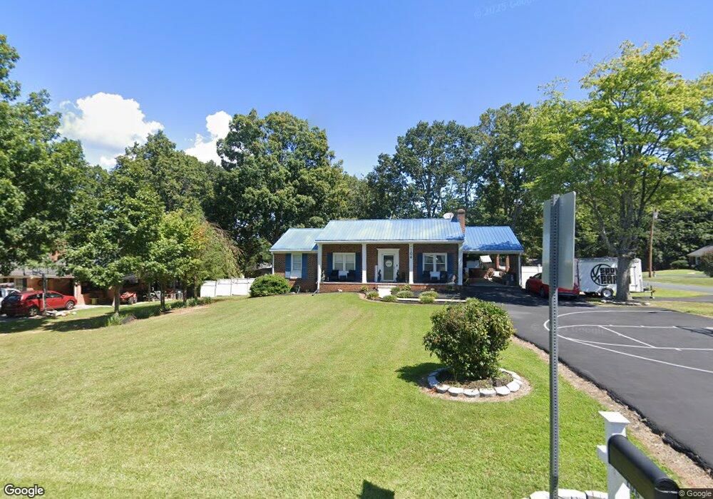
106 William Dr Madison Heights, VA 24572
Estimated Value: $225,000 - $255,000
3
Beds
2
Baths
1,222
Sq Ft
$198/Sq Ft
Est. Value
About This Home
This home is located at 106 William Dr, Madison Heights, VA 24572 and is currently estimated at $241,570, approximately $197 per square foot. 106 William Dr is a home located in Amherst County with nearby schools including Amelon Elementary School, Monelison Middle School, and Amherst County High School.
Ownership History
Date
Name
Owned For
Owner Type
Purchase Details
Closed on
Feb 23, 2017
Sold by
Hubbard Gary D and Tanner Fka Shamika L Hubbard Shamika L Hubbard
Bought by
Hubbard Gary D and Tanner Shamika L Hubbard
Current Estimated Value
Home Financials for this Owner
Home Financials are based on the most recent Mortgage that was taken out on this home.
Original Mortgage
$70,000
Outstanding Balance
$58,945
Interest Rate
5.25%
Mortgage Type
New Conventional
Estimated Equity
$182,625
Purchase Details
Closed on
Feb 25, 2014
Sold by
Deutsche Bank National Trust Co
Bought by
Hubbard Shamika L and Hubbard Gary D
Purchase Details
Closed on
Apr 26, 2013
Sold by
Professional Foreclosure Corporation Of
Bought by
Deutsche Bank National Trust Co and Morgan Stanley Abs Capital I Inc Trust 2
Create a Home Valuation Report for This Property
The Home Valuation Report is an in-depth analysis detailing your home's value as well as a comparison with similar homes in the area
Home Values in the Area
Average Home Value in this Area
Purchase History
| Date | Buyer | Sale Price | Title Company |
|---|---|---|---|
| Hubbard Gary D | -- | Attorney | |
| Hubbard Gary D | -- | Attorney | |
| Hubbard Shamika L | $78,000 | Chicago Title Ins Co | |
| Hubbard Shamika L | $78,000 | Chicago Title Ins Co | |
| Deutsche Bank National Trust Co | $104,125 | None Available | |
| Deutsche Bank National Trust Co | $104,125 | None Available |
Source: Public Records
Mortgage History
| Date | Status | Borrower | Loan Amount |
|---|---|---|---|
| Open | Hubbard Gary D | $70,000 |
Source: Public Records
Tax History
| Year | Tax Paid | Tax Assessment Tax Assessment Total Assessment is a certain percentage of the fair market value that is determined by local assessors to be the total taxable value of land and additions on the property. | Land | Improvement |
|---|---|---|---|---|
| 2026 | $1,504 | $246,600 | $24,000 | $222,600 |
| 2025 | $852 | $130,800 | $20,000 | $110,800 |
| 2024 | $798 | $130,800 | $20,000 | $110,800 |
| 2023 | $798 | $130,800 | $20,000 | $110,800 |
| 2022 | $798 | $130,800 | $20,000 | $110,800 |
| 2021 | $798 | $130,800 | $20,000 | $110,800 |
| 2020 | $798 | $130,800 | $20,000 | $110,800 |
| 2019 | $792 | $129,800 | $26,000 | $103,800 |
| 2018 | $792 | $129,800 | $26,000 | $103,800 |
| 2017 | $792 | $129,800 | $26,000 | $103,800 |
| 2016 | $792 | $129,800 | $26,000 | $103,800 |
| 2015 | $727 | $129,800 | $26,000 | $103,800 |
| 2014 | $727 | $129,800 | $26,000 | $103,800 |
Source: Public Records
Map
Nearby Homes
- 194 Melwood Dr
- 147 Stratford Place
- 208 Stratford Place
- TBD Stratford Place Unit 66
- 112 Hickory Way
- 0 Dixie Airport Rd Unit 364051
- 282 Shady Oak Dr
- 327 Dixie Airport Rd
- 4123 S Amherst Hwy
- 120 Jabo Ln
- 122 Gouyer Dr
- 111 Idlebrook Dr
- 505 Royal Gardens Ct
- 0 Lot 10 & 11 Stoney Creek Dr Unit 345183
- 156 Bryant Rd
- 0 Commonwealth Dr Unit 365878
- 115 Morgan Rd
- 143 Shannon Dr
- 1860 S Coolwell Rd
- 140 Garford Rd
- 106 William Dr
- 114 William Dr
- 114 William Dr
- 168 W Bethel Dr
- 107 William Dr
- 162 W Bethel Dr
- 199 W Bethel Dr
- 122 William Dr
- 115 William Dr
- 176 W Bethel Dr
- 154 W Bethel Dr
- 203 W Bethel Dr
- 221 W Bethel Dr
- 146 W Bethel Dr
- 128 William Dr
- 127 William Dr
- 196 W Bethel Dr
- 188 W Bethel Dr
- 204 W Bethel Dr
- 229 W Bethel Dr
Your Personal Tour Guide
Ask me questions while you tour the home.