Estimated Value: $190,000 - $276,000
3
Beds
2
Baths
1,624
Sq Ft
$138/Sq Ft
Est. Value
About This Home
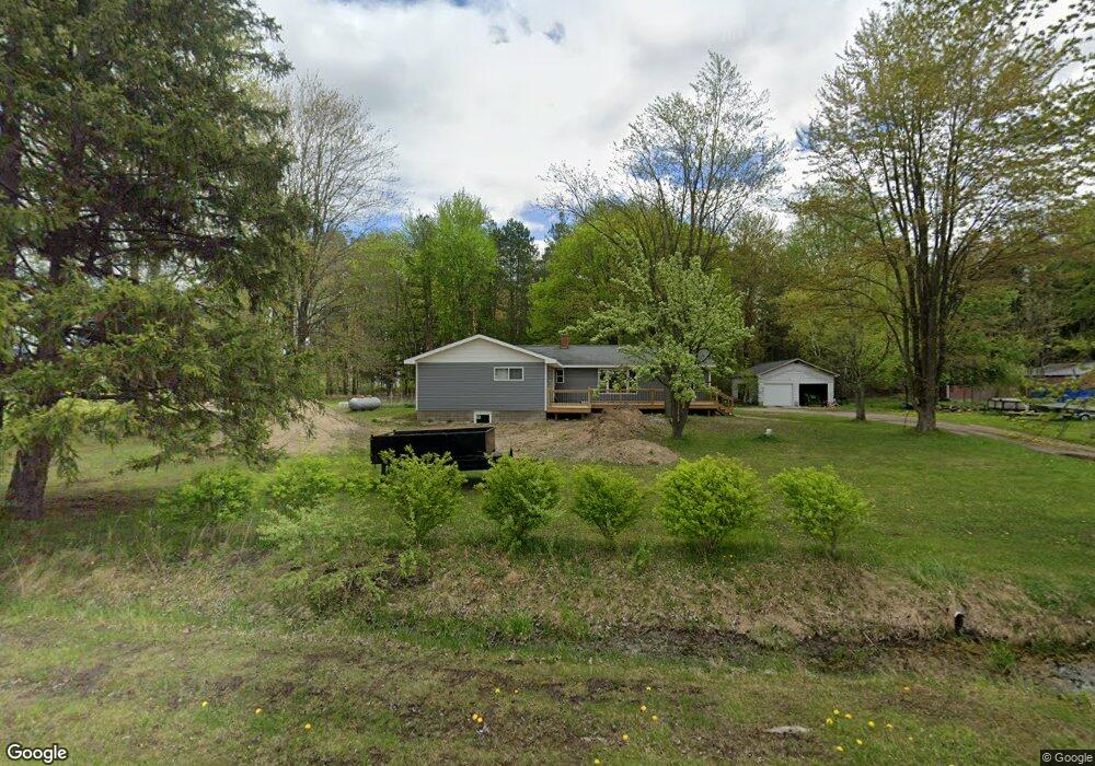
This home is located at 10805 S Brennan Rd, Brant, MI 48614 and is currently estimated at $224,876, approximately $138 per square foot. 10805 S Brennan Rd is a home located in Saginaw County with nearby schools including Big Rock Elementary School, Chesaning Middle School, and Chesaning Union High School.
Ownership History
Date
Name
Owned For
Owner Type
Purchase Details
Closed on
Aug 21, 2012
Sold by
Oikarinen Brian
Bought by
Oikarinen Brian and Johnson Nicole
Current Estimated Value
Purchase Details
Closed on
Nov 13, 2009
Sold by
Us Bank National Association
Bought by
Oikarinen Brian
Purchase Details
Closed on
Dec 5, 2008
Sold by
Murdock Amanda
Bought by
Us Bank Na
Purchase Details
Closed on
Nov 30, 2005
Sold by
Harris Melissa
Bought by
Murdock Amanda
Create a Home Valuation Report for This Property
The Home Valuation Report is an in-depth analysis detailing your home's value as well as a comparison with similar homes in the area
Purchase History
We collect this data history from publicly available records. To have your information removed, we recommend requesting removal directly through your county’s website.
| Date | Buyer | Sale Price | Title Company |
|---|---|---|---|
| Oikarinen Brian | -- | -- | |
| Oikarinen Brian | $31,000 | -- | |
| Us Bank Na | $59,900 | -- | |
| Murdock Amanda | $95,500 | -- |
Source: Public Records
Tax History
| Year | Tax Paid | Tax Assessment Tax Assessment Total Assessment is a certain percentage of the fair market value that is determined by local assessors to be the total taxable value of land and additions on the property. | Land | Improvement |
|---|---|---|---|---|
| 2025 | $642 | $76,300 | $0 | $0 |
| 2024 | $623 | $71,600 | $0 | $0 |
| 2023 | $593 | $71,600 | $0 | $0 |
| 2022 | $1,827 | $61,600 | $0 | $0 |
| 2021 | $1,715 | $55,400 | $0 | $0 |
| 2020 | $1,409 | $47,800 | $0 | $0 |
| 2019 | $1,351 | $47,300 | $12,800 | $34,500 |
| 2018 | $427 | $45,400 | $0 | $0 |
| 2017 | $1,211 | $44,700 | $0 | $0 |
| 2016 | $1,202 | $40,300 | $0 | $0 |
| 2014 | -- | $37,600 | $0 | $24,800 |
| 2013 | -- | $38,400 | $0 | $0 |
Source: Public Records
Map
Nearby Homes
- 10854 S Hemlock Rd
- 18303 Marion Rd
- 14540 Schroeder Rd
- 8501 S Raucholz Rd
- 14686 W Burt Rd
- 8602 S Fordney Rd
- 9.9 Acres Grabowski Rd
- West 80 Acres Grabowski Rd
- 78.23 Acres Grabowski Rd
- VL S Iva Rd
- 14274 W Gary Rd
- 11950 S Merrill Rd
- 9593 Oakley Rd
- 8013 S Merrill Rd
- 18125 Nelson Rd
- V/l S Fenmore Rd
- 13709 S Fenmore Rd
- 0 W Walnut St Unit 50159593
- 12000 W Townline Rd
- 12301 Niblock Rd
- 10815 S Brennan Rd
- 10753 S Brennan Rd
- 10825 S Brennan Rd
- 10750 S Brennan Rd
- 10955 S Brennan Rd
- 17110 W Brant Rd
- 16885 W Brant Rd
- 17113 W Brant Rd
- 16725 W Brant Rd
- 10410 S Brennan Rd
- 16619 W Brant Rd
- 17371 W Brant Rd
- 11237 S Brennan Rd
- 16607 W Brant Rd
- 11301 S Brennan Rd
- 13980 S Brennan Rd
- 10225 S Brennan Rd
- 16479 W Brant Rd
- 10288 S Brennan Rd
- 10288 S Brennan Rd
Your Personal Tour Guide
Ask me questions while you tour the home.