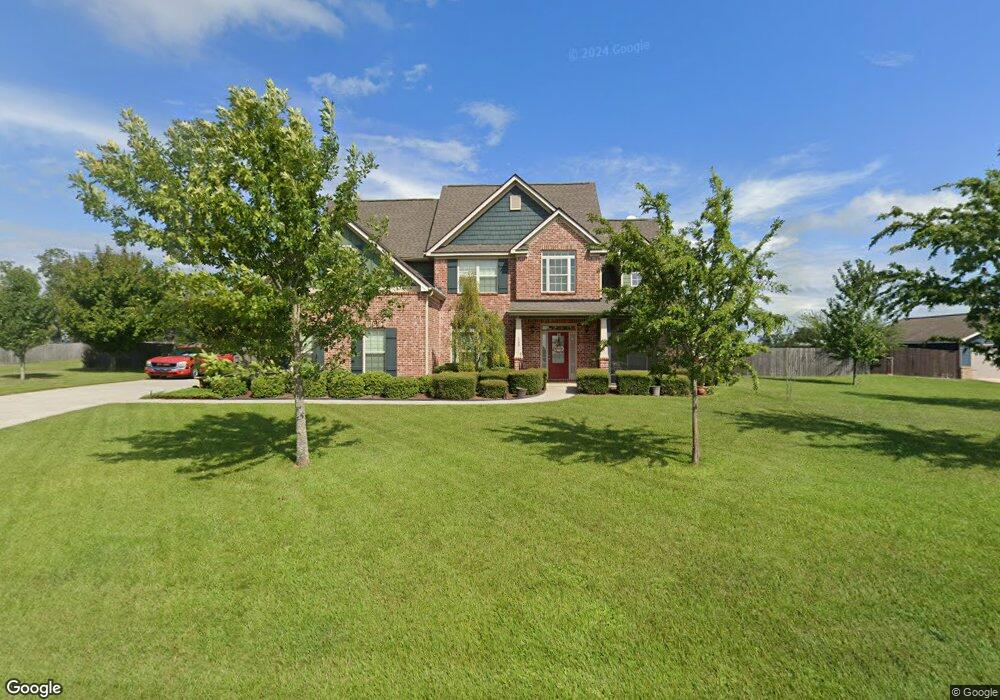
109 High Point Rd Newton, AL 36352
Estimated Value: $400,000 - $533,000
5
Beds
3
Baths
2,757
Sq Ft
$171/Sq Ft
Est. Value
About This Home
This home is located at 109 High Point Rd, Newton, AL 36352 and is currently estimated at $470,206, approximately $170 per square foot. 109 High Point Rd is a home located in Houston County with nearby schools including Wicksburg High School.
Ownership History
Date
Name
Owned For
Owner Type
Purchase Details
Closed on
Jul 6, 2017
Sold by
Edwards Nancy B and Seagers Holly
Bought by
Baird Clifton and Baird Sharon
Current Estimated Value
Home Financials for this Owner
Home Financials are based on the most recent Mortgage that was taken out on this home.
Original Mortgage
$93,000
Outstanding Balance
$76,833
Interest Rate
3.95%
Mortgage Type
New Conventional
Estimated Equity
$393,373
Purchase Details
Closed on
Oct 15, 2012
Sold by
Auburdan Inc
Bought by
Seagers Todd and Seagers Holly
Purchase Details
Closed on
Apr 25, 2012
Sold by
Hicks David G
Bought by
Auburdan Inc
Home Financials for this Owner
Home Financials are based on the most recent Mortgage that was taken out on this home.
Original Mortgage
$225,000
Interest Rate
4.13%
Create a Home Valuation Report for This Property
The Home Valuation Report is an in-depth analysis detailing your home's value as well as a comparison with similar homes in the area
Purchase History
We collect this data history from publicly available records. To have your information removed, we recommend requesting removal directly through your county’s website.
| Date | Buyer | Sale Price | Title Company |
|---|---|---|---|
| Baird Clifton | $294,900 | -- | |
| Seagers Todd | -- | -- | |
| Auburdan Inc | -- | -- |
Source: Public Records
Mortgage History
We collect this data history from publicly available records. To have your information removed, we recommend requesting removal directly through your county’s website.
| Date | Status | Borrower | Loan Amount |
|---|---|---|---|
| Open | Baird Clifton | $93,000 | |
| Previous Owner | Auburdan Inc | $225,000 |
Source: Public Records
Tax History
| Year | Tax Paid | Tax Assessment Tax Assessment Total Assessment is a certain percentage of the fair market value that is determined by local assessors to be the total taxable value of land and additions on the property. | Land | Improvement |
|---|---|---|---|---|
| 2025 | -- | $45,280 | $0 | $0 |
| 2024 | $1,272 | $43,120 | $0 | $0 |
| 2023 | $1,220 | $41,340 | $0 | $0 |
| 2022 | $1,022 | $34,640 | $0 | $0 |
| 2021 | $989 | $33,540 | $0 | $0 |
| 2020 | $930 | $31,540 | $0 | $0 |
| 2019 | $894 | $30,300 | $0 | $0 |
| 2018 | $0 | $29,320 | $0 | $0 |
| 2017 | $0 | $24,920 | $0 | $0 |
| 2016 | -- | $0 | $0 | $0 |
| 2015 | -- | $0 | $0 | $0 |
| 2014 | -- | $0 | $0 | $0 |
Source: Public Records
Map
Nearby Homes
- 776 County Road 68
- 3578 N County Road 9
- 0 Fortner St
- 3259 N County Road 9
- 3115 Cumbie Rd
- 0 Highway 68
- 1 Highway 68
- 481 Grace Dr
- 1.0 acre Hollis Dairy Road Lot 3
- 1.0 acre Hollis Dairy Rd Lot 1
- 1.0 acre Hollis Dairy Rd Lot 2
- 360 Sherwood Trail
- 797 Judge Logue Rd
- 1381 N State Highway 103
- 527 Sasser Rd
- 652 Doyle Rd
- 2156 County Road 73
- TBD Judge Logue Rd
- 1041 & 0 County Road 73
- 0 Holmes Rd
- 139 High Point Rd
- 71 High Point Rd
- 118 High Point Rd
- 70 High Point Rd
- 173 High Point Rd
- 160 High Point Rd
- 3153 S County Road 9
- 3153 N County Road 9
- 3135 S County Road 9
- 3151 S County Road 9
- 30 High Point Rd
- 200 High Point Rd
- 3147 S County Road 9
- 221 High Point Rd
- 3291 S County Road 9
- 3045 S County Road 9
- 3045 S County Road 9
- 3033 S County Road 9
- 2981 County Road 9
- 2981 S County Road 9
Your Personal Tour Guide
Ask me questions while you tour the home.