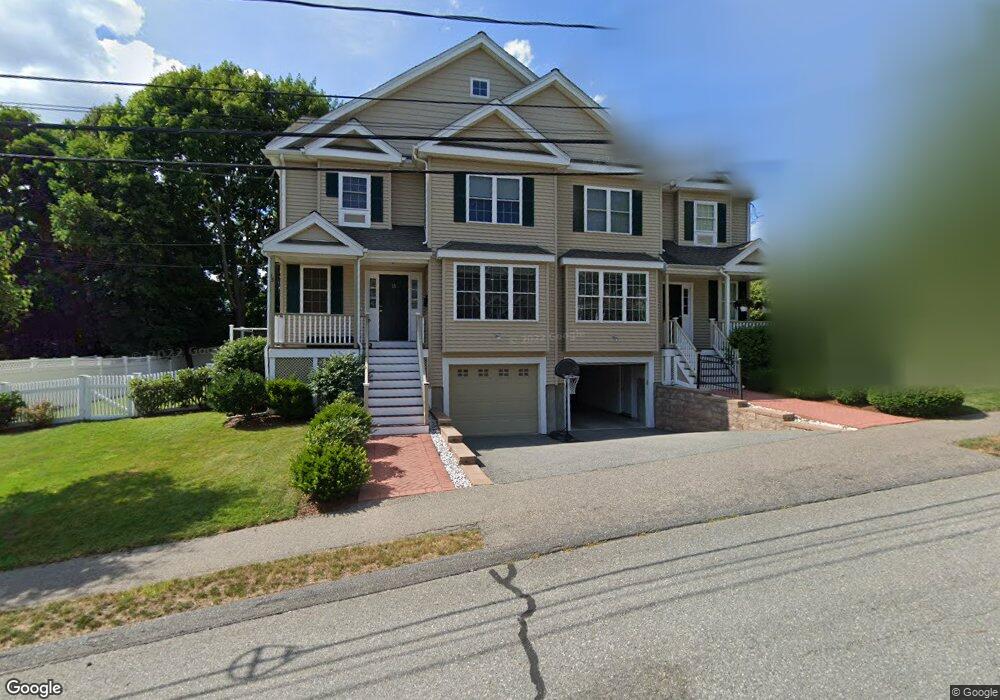
11 Bobsled Dr Needham Heights, MA 02494
Estimated Value: $1,042,000 - $1,600,207
4
Beds
3
Baths
2,948
Sq Ft
$464/Sq Ft
Est. Value
About This Home
This home is located at 11 Bobsled Dr, Needham Heights, MA 02494 and is currently estimated at $1,369,052, approximately $464 per square foot. 11 Bobsled Dr is a home located in Norfolk County with nearby schools including Sunita L. Williams Elementary School, High Rock Middle School, and Pollard Middle School.
Ownership History
Date
Name
Owned For
Owner Type
Purchase Details
Closed on
Nov 2, 2007
Sold by
Constr North Shore
Bought by
Hayden Gerard M and Hayden Patricia S
Current Estimated Value
Home Financials for this Owner
Home Financials are based on the most recent Mortgage that was taken out on this home.
Original Mortgage
$415,000
Outstanding Balance
$263,251
Interest Rate
6.43%
Mortgage Type
Purchase Money Mortgage
Estimated Equity
$1,105,801
Create a Home Valuation Report for This Property
The Home Valuation Report is an in-depth analysis detailing your home's value as well as a comparison with similar homes in the area
Home Values in the Area
Average Home Value in this Area
Purchase History
We collect this data history from publicly available records. To have your information removed, we recommend requesting removal directly through your county’s website.
| Date | Buyer | Sale Price | Title Company |
|---|---|---|---|
| Hayden Gerard M | $700,000 | -- |
Source: Public Records
Mortgage History
We collect this data history from publicly available records. To have your information removed, we recommend requesting removal directly through your county’s website.
| Date | Status | Borrower | Loan Amount |
|---|---|---|---|
| Open | Hayden Gerard M | $415,000 |
Source: Public Records
Tax History
| Year | Tax Paid | Tax Assessment Tax Assessment Total Assessment is a certain percentage of the fair market value that is determined by local assessors to be the total taxable value of land and additions on the property. | Land | Improvement |
|---|---|---|---|---|
| 2025 | $15,505 | $1,462,700 | $0 | $1,462,700 |
| 2024 | $14,283 | $1,140,800 | $0 | $1,140,800 |
| 2023 | $14,304 | $1,096,900 | $0 | $1,096,900 |
| 2022 | $13,212 | $988,200 | $0 | $988,200 |
| 2021 | $12,876 | $988,200 | $0 | $988,200 |
| 2020 | $12,343 | $988,200 | $0 | $988,200 |
| 2019 | $10,637 | $858,500 | $0 | $858,500 |
| 2018 | $10,199 | $858,500 | $0 | $858,500 |
| 2017 | $9,719 | $817,400 | $0 | $817,400 |
| 2016 | $9,433 | $817,400 | $0 | $817,400 |
| 2015 | $8,963 | $793,900 | $0 | $793,900 |
| 2014 | $8,798 | $755,800 | $0 | $755,800 |
Source: Public Records
Map
Nearby Homes
- 102 Booth St
- 213 Hunnewell St
- 11 Greenough St
- 140 Hillside Ave
- 140 Hillside Ave Unit a
- 56 Crescent Rd
- 56 Crescent Rd Unit 56
- 134 Hillside Ave Unit 134
- 48 Taylor St
- 20 Crescent Rd Unit 20
- 4 Park River St
- 170 West St Unit 170
- 170 West St
- 81 Parish Rd
- 447 Hillside Ave
- 23 Yale Rd
- 75 Wellesley Ave
- 30 Webster St Unit 3
- 48 Gary Rd
- 114 Parish Rd
- 25 Castano Ct
- 24 Castano Ct
- 31 Bobsled Dr
- 31 Bobsled Dr Unit 31
- 31 Bobsled Dr Unit 1
- 23 Bobsled Dr
- 23 Bobsled Dr Unit 23
- 21 Bobsled Dr
- 33 Bobsled Dr
- 110 Booth St
- 21 Castano Ct
- 96 Booth St
- 10 Castano Ct
- 15 Bobsled Dr
- 39 Bobsled Dr
- 41 Bobsled Dr
- 24 Bobsled Dr
- 267 Hunnewell St
- 17 Castano Ct
- 22 Bobsled Dr
Your Personal Tour Guide
Ask me questions while you tour the home.