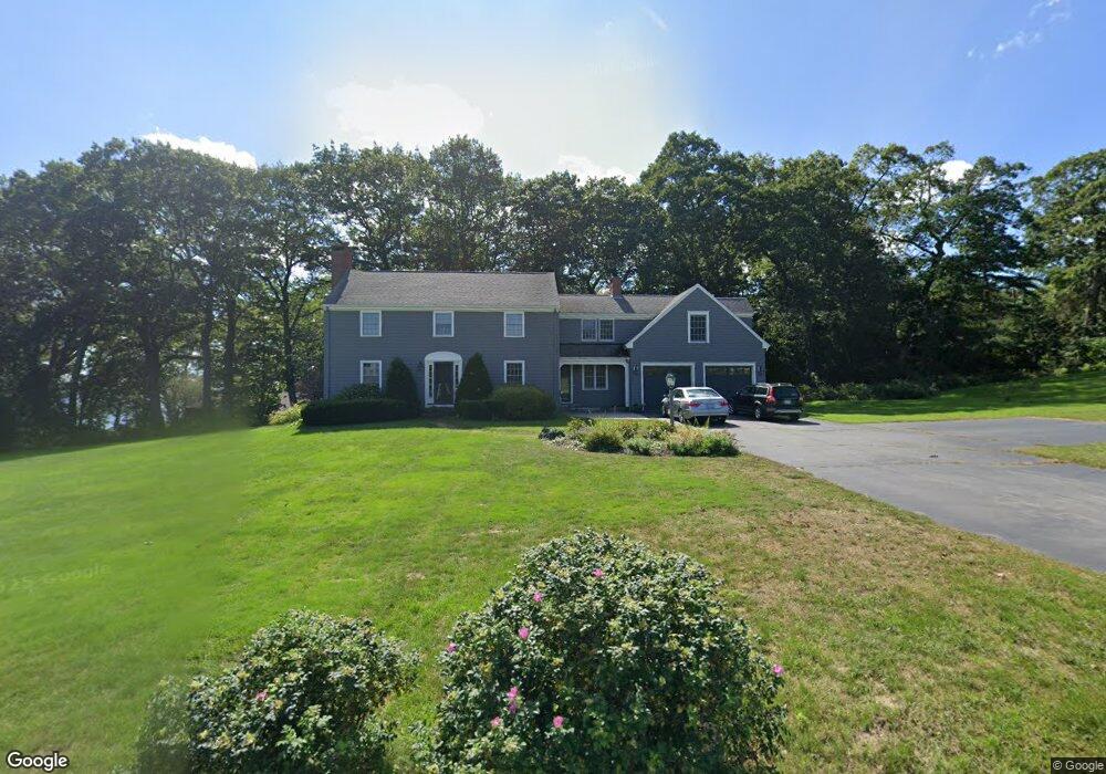
11 Lantern Ln Cumberland Foreside, ME 04110
Cumberland Foreside NeighborhoodEstimated Value: $1,601,000 - $1,896,000
3
Beds
3
Baths
2,776
Sq Ft
$619/Sq Ft
Est. Value
About This Home
This home is located at 11 Lantern Ln, Cumberland Foreside, ME 04110 and is currently estimated at $1,719,141, approximately $619 per square foot. 11 Lantern Ln is a home located in Cumberland County with nearby schools including Mabel I. Wilson School, Greely Middle School 4-5, and Greely Middle School.
Ownership History
Date
Name
Owned For
Owner Type
Purchase Details
Closed on
Oct 1, 2008
Sold by
Traynor Kathleen P and Traynor Richard
Bought by
Theodores Matthew L and Theodores Ellen H
Current Estimated Value
Home Financials for this Owner
Home Financials are based on the most recent Mortgage that was taken out on this home.
Original Mortgage
$417,000
Interest Rate
6.54%
Mortgage Type
Unknown
Create a Home Valuation Report for This Property
The Home Valuation Report is an in-depth analysis detailing your home's value as well as a comparison with similar homes in the area
Home Values in the Area
Average Home Value in this Area
Purchase History
| Date | Buyer | Sale Price | Title Company |
|---|---|---|---|
| Theodores Matthew L | -- | -- |
Source: Public Records
Mortgage History
| Date | Status | Borrower | Loan Amount |
|---|---|---|---|
| Open | Theodores Matthew L | $417,000 | |
| Closed | Theodores Matthew L | $417,000 |
Source: Public Records
Tax History
| Year | Tax Paid | Tax Assessment Tax Assessment Total Assessment is a certain percentage of the fair market value that is determined by local assessors to be the total taxable value of land and additions on the property. | Land | Improvement |
|---|---|---|---|---|
| 2025 | $18,009 | $715,200 | $432,000 | $283,200 |
| 2024 | $16,628 | $715,200 | $432,000 | $283,200 |
| 2023 | $15,842 | $715,200 | $432,000 | $283,200 |
| 2022 | $14,730 | $694,800 | $432,000 | $262,800 |
| 2021 | $14,278 | $694,800 | $432,000 | $262,800 |
| 2020 | $14,139 | $694,800 | $432,000 | $262,800 |
| 2019 | $13,792 | $694,800 | $432,000 | $262,800 |
| 2018 | $13,607 | $690,700 | $432,000 | $258,700 |
| 2017 | $12,985 | $690,700 | $432,000 | $258,700 |
| 2016 | $12,605 | $690,700 | $432,000 | $258,700 |
| 2015 | $12,502 | $690,700 | $432,000 | $258,700 |
| 2014 | $12,018 | $690,700 | $432,000 | $258,700 |
| 2013 | $11,742 | $690,700 | $432,000 | $258,700 |
Source: Public Records
Map
Nearby Homes
- 24 Amerescoggin Rd
- 59 Underwood Rd
- 24 Johnson Rd
- 52 Maeves Way
- 252 Foreside Rd
- 35 Deans Way
- 10 Eagles Way Unit 10
- 76 Johnson Rd
- 9 Conifer Ridge
- 267 U S Route 1 Unit 308
- 5 & 6 Harmony Way
- 5 Harmony Way
- 267 U S 1 Unit 305
- 267 U S 1 Unit 301
- 267 U S 1 Unit 404
- 267 U S 1 Unit 201
- 267 U S 1 Unit 309
- 267 U S 1 Unit PH503
- 93 Foreside Rd
- 20 Depot Rd
Your Personal Tour Guide
Ask me questions while you tour the home.