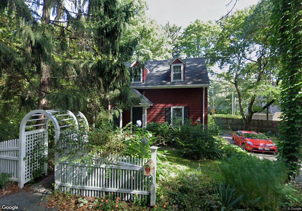
11 Loring Rd Weston, MA 02493
Estimated Value: $926,394 - $1,538,000
About This Home
This home is located at 11 Loring Rd, Weston, MA 02493 and is currently estimated at $1,192,599, approximately $622 per square foot. 11 Loring Rd is a home located in Middlesex County with nearby schools including Country Elementary School, Woodland Elementary School, and Field Elementary School.
Ownership History
We collect this data history from publicly available records. To have your information removed, we recommend requesting removal directly through your county’s website.
Purchase Details
Purchase Details
Home Values in the Area
Average Home Value in this Area
Purchase History
We collect this data history from publicly available records. To have your information removed, we recommend requesting removal directly through your county’s website.
| Date | Buyer | Sale Price | Title Company |
|---|---|---|---|
| -- | None Available | ||
| -- | None Available | ||
| $255,000 | -- | ||
| $255,000 | -- |
Mortgage History
We collect this data history from publicly available records. To have your information removed, we recommend requesting removal directly through your county’s website.
| Date | Status | Borrower | Loan Amount |
|---|---|---|---|
| Previous Owner | $100,000 | ||
| Previous Owner | $193,000 |
Tax History
We collect this data history from publicly available records. To have your information removed, we recommend requesting removal directly through your county’s website.
| Year | Tax Paid | Tax Assessment Tax Assessment Total Assessment is a certain percentage of the fair market value that is determined by local assessors to be the total taxable value of land and additions on the property. | Land | Improvement |
|---|---|---|---|---|
| 2025 | $8,036 | $724,000 | $424,400 | $299,600 |
| 2024 | $7,850 | $705,900 | $424,400 | $281,500 |
| 2023 | $7,715 | $651,600 | $424,400 | $227,200 |
| 2022 | $7,668 | $598,600 | $404,500 | $194,100 |
| 2021 | $7,412 | $571,000 | $385,900 | $185,100 |
| 2020 | $7,144 | $556,800 | $385,900 | $170,900 |
| 2019 | $6,611 | $525,100 | $357,200 | $167,900 |
| 2018 | $6,569 | $525,100 | $357,200 | $167,900 |
| 2017 | $6,511 | $525,100 | $357,200 | $167,900 |
| 2016 | $6,385 | $525,100 | $357,200 | $167,900 |
| 2015 | $5,299 | $431,500 | $295,800 | $135,700 |
Map
- 39 Charles St Unit A
- 44 Meadowbrook Rd
- 126 Charles St (Aub)
- 2239 Commonwealth Ave Unit 2239
- 9 Johnson Place Unit 9
- 305 Central St
- 19 Rockwood Terrace
- 372 Central St
- 80 Doublet Hill Rd
- 283 Melrose St
- 16 Ware Rd
- 22 Irene Cir
- 56 Cart Path Rd
- 349 Auburndale Ave
- 130 Summer St
- 2031 Commonwealth Ave
- 70 Possum Rd
- 194 Auburn St Unit 2
- 288 Auburndale Ave Unit B
- 4 Willow Rd
Ask me questions while you tour the home.