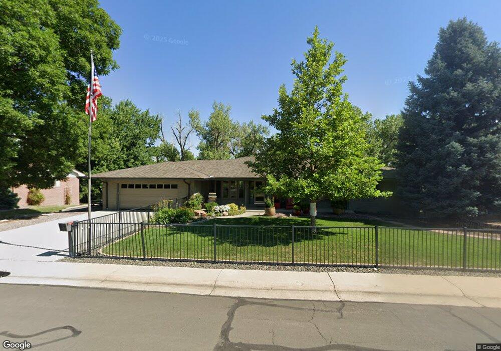
11 Rangeview Dr Wheat Ridge, CO 80215
Applewood Valley NeighborhoodEstimated Value: $1,206,475 - $1,641,000
About This Home
This home is located at 11 Rangeview Dr, Wheat Ridge, CO 80215 and is currently estimated at $1,415,619, approximately $323 per square foot. 11 Rangeview Dr is a home located in Jefferson County with nearby schools including Stober Elementary School, Everitt Middle School, and Wheat Ridge High School.
Ownership History
We collect this data history from publicly available records. To have your information removed, we recommend requesting removal directly through your county’s website.
Purchase Details
Purchase Details
Purchase Details
Home Financials for this Owner
Home Financials are based on the most recent Mortgage that was taken out on this home.Home Values in the Area
Average Home Value in this Area
Purchase History
We collect this data history from publicly available records. To have your information removed, we recommend requesting removal directly through your county’s website.
| Date | Buyer | Sale Price | Title Company |
|---|---|---|---|
| -- | None Available | ||
| $524,000 | None Available | ||
| $540,000 | Atgf |
Mortgage History
We collect this data history from publicly available records. To have your information removed, we recommend requesting removal directly through your county’s website.
| Date | Status | Borrower | Loan Amount |
|---|---|---|---|
| Previous Owner | $359,650 |
Tax History
We collect this data history from publicly available records. To have your information removed, we recommend requesting removal directly through your county’s website.
| Year | Tax Paid | Tax Assessment Tax Assessment Total Assessment is a certain percentage of the fair market value that is determined by local assessors to be the total taxable value of land and additions on the property. | Land | Improvement |
|---|---|---|---|---|
| 2025 | $5,196 | $58,432 | $24,225 | $34,207 |
| 2024 | $5,027 | $60,860 | $24,749 | $36,111 |
| 2023 | $5,027 | $60,860 | $24,749 | $36,111 |
| 2022 | $4,525 | $47,628 | $17,523 | $30,105 |
| 2021 | $4,560 | $48,999 | $18,027 | $30,972 |
| 2020 | $4,150 | $44,626 | $14,733 | $29,893 |
| 2019 | $4,095 | $44,626 | $14,733 | $29,893 |
| 2018 | $4,125 | $43,817 | $11,835 | $31,982 |
| 2017 | $3,807 | $43,817 | $11,835 | $31,982 |
| 2016 | $3,852 | $41,848 | $11,250 | $30,598 |
| 2015 | $3,321 | $41,848 | $11,250 | $30,598 |
| 2014 | $3,321 | $33,607 | $9,353 | $24,254 |
Map
- 3076 Nelson Ct
- 5 Circle Dr
- 3210 Parfet St
- 2900 Quail St
- 34 Skyline Dr
- 3391 Oak St
- 11328 W 27th Ave
- 2987 Routt Cir
- 2490 Lewis St
- 10125 W 25th Ave Unit 43
- 9985 W 32nd Ave
- 2560 Queen St
- 3500 Miller St
- 10560 W 23rd Place
- 11546 W 26th Place
- 11575 W 32nd Ave
- 3640 Lewis St
- 11793 W 28th Ave
- 3660 Lee St
- 3736 Miller Ct
Ask me questions while you tour the home.