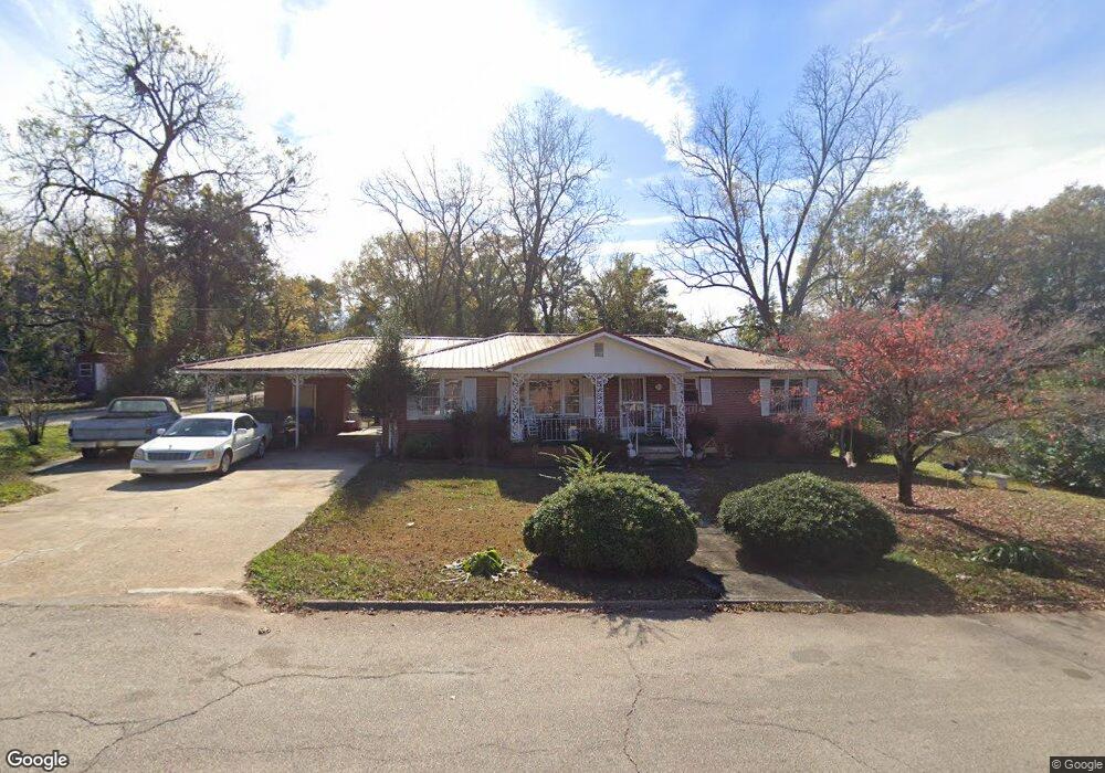
1106 E 9th St West Point, GA 31833
Estimated Value: $129,000 - $140,000
3
Beds
2
Baths
1,896
Sq Ft
$70/Sq Ft
Est. Value
About This Home
This home is located at 1106 E 9th St, West Point, GA 31833 and is currently estimated at $133,212, approximately $70 per square foot. 1106 E 9th St is a home located in Troup County with nearby schools including West Point Elementary School, Long Cane Elementary School, and Whitesville Road Elementary School.
Ownership History
Date
Name
Owned For
Owner Type
Purchase Details
Closed on
Jun 17, 2004
Sold by
Velma Shevon and Velma Carr
Bought by
Williams Thelma W
Current Estimated Value
Purchase Details
Closed on
May 8, 1998
Sold by
Emma Carr
Bought by
Velma Shevon and Velma Carr
Purchase Details
Closed on
Oct 24, 1996
Sold by
Emma Ferrell Carr Life Estate
Bought by
Emma Carr
Purchase Details
Closed on
Oct 25, 1991
Sold by
Willie Lewis Carr
Bought by
Emma Ferrell Carr Life Estate
Purchase Details
Closed on
Jan 1, 1959
Sold by
Charles Jarrett
Bought by
Willie Lewis Carr
Create a Home Valuation Report for This Property
The Home Valuation Report is an in-depth analysis detailing your home's value as well as a comparison with similar homes in the area
Home Values in the Area
Average Home Value in this Area
Purchase History
| Date | Buyer | Sale Price | Title Company |
|---|---|---|---|
| Williams Thelma W | $78,000 | -- | |
| Velma Shevon | -- | -- | |
| Emma Carr | -- | -- | |
| Emma Ferrell Carr Life Estate | -- | -- | |
| Willie Lewis Carr | -- | -- |
Source: Public Records
Tax History
| Year | Tax Paid | Tax Assessment Tax Assessment Total Assessment is a certain percentage of the fair market value that is determined by local assessors to be the total taxable value of land and additions on the property. | Land | Improvement |
|---|---|---|---|---|
| 2025 | $2,334 | $66,880 | $2,760 | $64,120 |
| 2024 | $1,530 | $43,240 | $2,760 | $40,480 |
| 2023 | $1,501 | $42,160 | $2,760 | $39,400 |
| 2022 | $1,124 | $40,280 | $2,760 | $37,520 |
| 2021 | $344 | $40,120 | $2,760 | $37,360 |
| 2020 | $590 | $29,520 | $1,440 | $28,080 |
| 2019 | $570 | $28,872 | $1,472 | $27,400 |
| 2018 | $532 | $27,592 | $1,472 | $26,120 |
| 2017 | $532 | $27,592 | $1,472 | $26,120 |
| 2016 | $520 | $27,195 | $1,472 | $25,723 |
| 2015 | $521 | $27,195 | $1,472 | $25,723 |
| 2014 | $480 | $25,841 | $1,472 | $24,369 |
| 2013 | -- | $27,568 | $1,472 | $26,096 |
Source: Public Records
Map
Nearby Homes
- 0 Arrowhead Dr Unit 10451860
- 1104 E 8th St
- 900 E 9th St
- 509 Cleveland St
- 707 E 7th St
- 1202 E 9th St
- 1418 E 10th St
- 506 E 6th St
- 0 Sunset Dr Unit 10451831
- 112 Hillcrest Rd
- 128 Highland Dr
- 712 4th Ave
- 1007 4th Ave
- 1800 Malco Dr
- 508 Pine St
- 4517 Georgia 18
- 4509 Georgia 18
- 4523 Georgia 18
- 4527 Georgia 18
- 1903 Ridgewood Dr
- 1200 E 9th St
- 1201 E 9th St
- 0 Arrowhead Dr Unit 8430064
- 0 Arrowhead Dr Unit 6 8317196
- 0 Arrowhead Dr Unit LOT 6 7123337
- 0 Arrowhead Dr Unit 7411542
- 0 Arrowhead Dr Unit 7633723
- 0 Arrowhead Dr Unit LOT 6 8050569
- 0 Arrowhead Dr Unit 10338821
- 0 Arrowhead Dr Unit 8937065
- 0 Arrowhead Dr Unit 8872320
- 1204 E 9th St
- 1105 E 9th St
- 1201 E 8th St
- 805 Avenue K
- 800 Avenue K
- 1206 E 9th St
- 901 Avenue K
- 1007 E 8th St
- 901 Avenue M
Your Personal Tour Guide
Ask me questions while you tour the home.