Estimated Value: $322,000 - $503,000
4
Beds
3
Baths
3,263
Sq Ft
$118/Sq Ft
Est. Value
About This Home
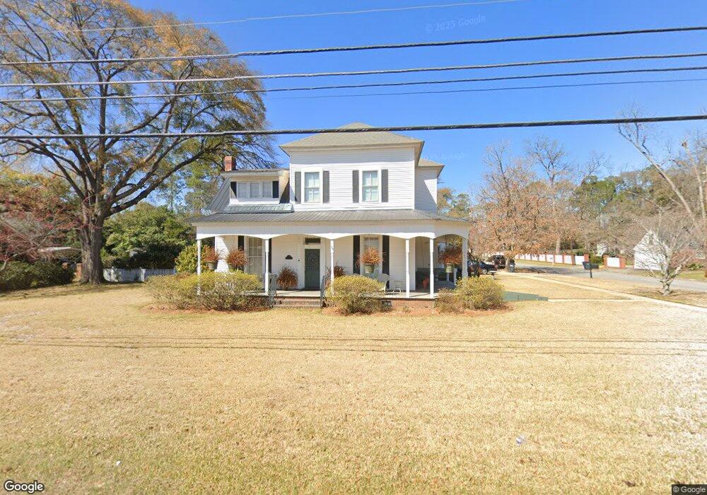
This home is located at 1107 Swift St, Perry, GA 31069 and is currently estimated at $386,013, approximately $118 per square foot. 1107 Swift St is a home located in Houston County with nearby schools including Morningside Elementary School, Perry Middle School, and Perry High School.
Ownership History
Date
Name
Owned For
Owner Type
Purchase Details
Closed on
Jun 17, 1988
Sold by
Right Of Way
Bought by
Abney Joe Kenneth and Abney Beverly A
Current Estimated Value
Purchase Details
Closed on
Apr 14, 1979
Sold by
Keen Robert H and Judith Poe
Bought by
Abney Joe Kenneth and Abney Beverly A
Purchase Details
Closed on
Sep 16, 1971
Sold by
Parkinson Parkinson J and Parkinson Betty C
Bought by
Keen Robert H and Judith Poe
Purchase Details
Closed on
Oct 20, 1967
Sold by
M M & B Inc
Bought by
Parkinson Parkinson J and Parkinson Betty C
Create a Home Valuation Report for This Property
The Home Valuation Report is an in-depth analysis detailing your home's value as well as a comparison with similar homes in the area
Home Values in the Area
Average Home Value in this Area
Purchase History
| Date | Buyer | Sale Price | Title Company |
|---|---|---|---|
| Abney Joe Kenneth | -- | -- | |
| Abney Joe Kenneth | -- | -- | |
| Keen Robert H | -- | -- | |
| Parkinson Parkinson J | -- | -- |
Source: Public Records
Tax History
| Year | Tax Paid | Tax Assessment Tax Assessment Total Assessment is a certain percentage of the fair market value that is determined by local assessors to be the total taxable value of land and additions on the property. | Land | Improvement |
|---|---|---|---|---|
| 2025 | $2,920 | $92,240 | $6,000 | $86,240 |
| 2024 | $3,220 | $88,880 | $6,920 | $81,960 |
| 2023 | $2,805 | $77,080 | $6,920 | $70,160 |
| 2022 | $1,574 | $70,440 | $6,920 | $63,520 |
| 2021 | $1,465 | $65,360 | $6,920 | $58,440 |
| 2020 | $1,370 | $60,960 | $6,920 | $54,040 |
| 2019 | $1,370 | $60,960 | $6,920 | $54,040 |
| 2018 | $1,370 | $60,960 | $6,920 | $54,040 |
| 2017 | $1,371 | $60,960 | $6,920 | $54,040 |
| 2016 | $1,373 | $60,960 | $6,920 | $54,040 |
| 2015 | $1,423 | $60,960 | $6,920 | $54,040 |
| 2014 | -- | $60,960 | $6,920 | $54,040 |
| 2013 | -- | $60,840 | $6,920 | $53,920 |
Source: Public Records
Map
Nearby Homes
- 1205 Swift St
- 0 Carroll Aly
- 202 Farrell Way
- 101 Red Cedar Run
- 207 Farrell Way
- 107 Pridgen Pass
- 100 Pridgen Pass
- 118 Pridgen Pass
- 119 Pridgen Pass
- 205 Farrell Way
- 106 Cassandra Ann Way
- 1418 Parkway Dr
- 1512 State St
- 0 Perimeter Rd Unit 236479
- 0 Perimeter Rd Unit 20145467
- 0 Perimeter Rd Unit 236478
- 411 Stonegate Trail
- 415 Stonegate Trail
- 634 Pine Ridge St
- 625 Cooper St
- 1107 2nd St Unit . 2
- 1107 2nd St Unit . 1
- 1105 Swift St
- 1103 2nd St
- 1103 S 2nd St Unit 4
- 1103 S 2nd St
- 1107 S 2nd St Unit 2
- LOT 87 Sadie Heights
- LOT 83 Sadie Heights
- LOT 91 Sadie Heights
- LOT 91 Sadie Heights Unit 91
- 1201 Swift St
- 1103 Swift St
- LOT 204 Rambo Way
- LOT 202 Rambo Way
- 1200 Swift St
- 1101 Swift St
- 1203A Swift St
- LOT 60 Bankstone Landing
- LOT 65 Bankstone Landing
Your Personal Tour Guide
Ask me questions while you tour the home.