NOT LISTED FOR SALE

Estimated Value: $320,549 - $601,000

4.19 Acres
$102,061 Price per Acre
182,516 Sq Ft Lot

Last Sold September 09, 2019

Last sale price $250,000

Est. 71% increase in value since last sale

Current estimated payment $2,493/month

3 Days on Market

Highlights

  • Deeded Waterfront Access Rights
  • View of Trees or Woods
  • Wooded Lot
  • Ocean Front
  • 4.19 Acre Lot
  • No HOA

About This Lot

As of September 2019

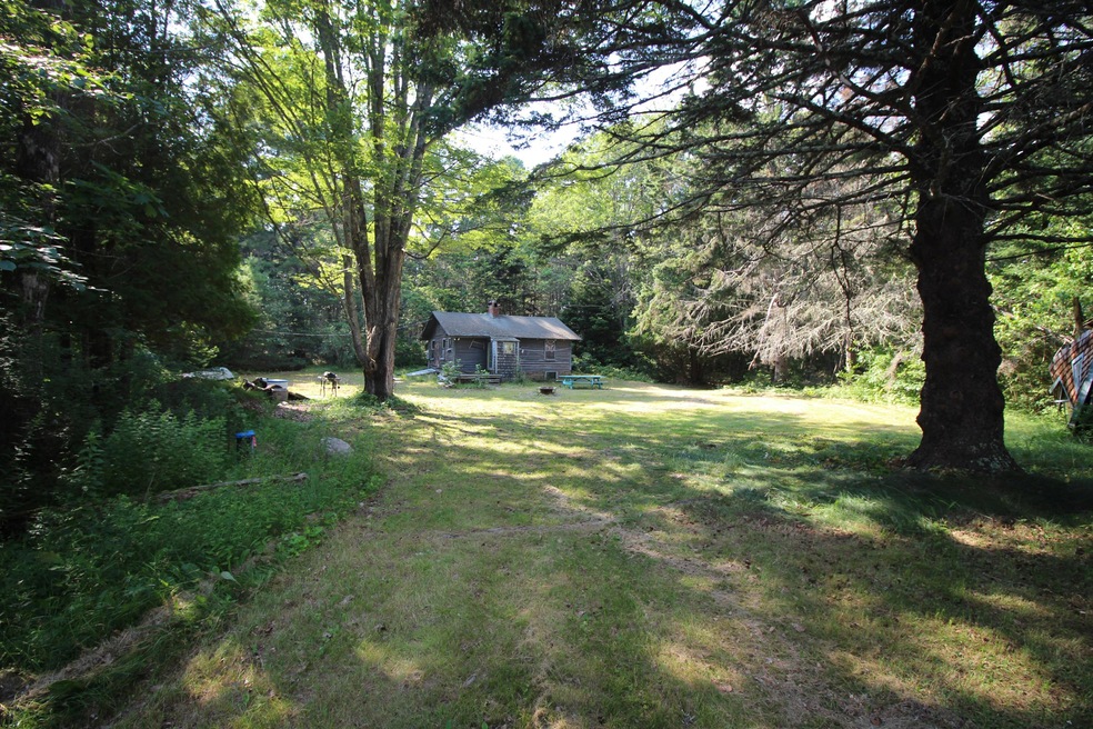
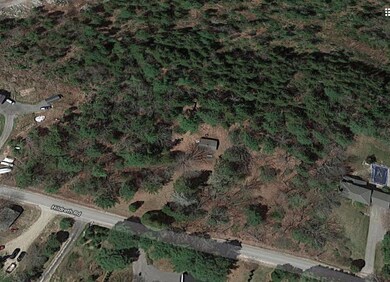
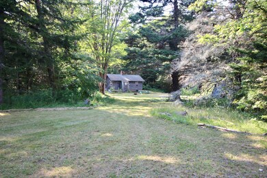
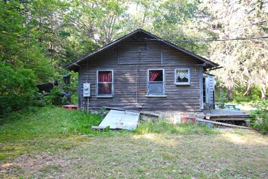
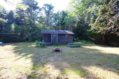
Unique opportunity to own on Hildreth Rd! Beautiful acreage and improvements such as new artesian well, electric on site and two antique cabins circa 1936, in need of multiple repairs! Near the town landing. Possibilities to divide into more than one building lot! Needs septic design.

Last Agent to Sell the Property

Deborah Johnson

Rob Williams Real Estate Brokers Listed on: 08/06/2019

Last Buyer's Agent

Deborah Johnson

Rob Williams Real Estate Brokers Listed on: 08/06/2019

Property Details

Property Type

  • Land

Est. Annual Taxes

  • $968

Lot Details

  • 4.19 Acre Lot
  • Ocean Front
  • Near Conservation Area
  • Street terminates at a dead end
  • Rural Setting
  • Interior Lot
  • Level Lot
  • Open Lot
  • Wooded Lot

Parking

  • Gravel Driveway

Property Views

  • Views of Woods

Utilities

  • Natural Gas Not Available
  • Private Water Source
  • Well
  • Sewer Not Available

Listing and Financial Details

  • Tax Lot 67
  • Assessor Parcel Number HARP-000003-000000-000067

Community Details

Overview

  • No Home Owners Association

Recreation

  • Deeded Waterfront Access Rights
  • Nearby Water Access
  • Deep Water Access

Property Details

Property Type

Land

Est. Annual Taxes

$968

Lot Details

0

Listing Details

  • Prop. Type: Land
  • Lot Size Acres: 4.19
  • Road Surface Type: Paved
  • Water Body Name: Ewing Narrows
  • MLS Status: Closed
  • Directions: TURN OFF MOUNTAIN RD. ONTO HILDRETH RD. FOLLOW TO SIGN ON LEFT 111 HILDRETH RD
  • Property Information:Lot Size Acres -: 4.19
  • Site:Level: Yes
  • Site:Open: Yes
  • Water Info:Water Frontage2: No
  • Water Info:Water View2: No
  • Gas:No Gas: Yes
  • Property Information:Short Sale Continue to Show: No
  • Recreational Water:Nearby: Yes
  • Recreational Water:Oceanfront: Yes
  • Location:Rural: Yes
  • Roads:Dead End: Yes
  • Recreational Water:Deeded: Yes
  • Recreational Water:Waterfront Deep: Yes
  • Water:Private2: Yes
  • Driveway:Gravel: Yes
  • Site:Wooded: Yes
  • View:TreesWoods: Yes
  • Site:RollingSloping: Yes
  • Water:Well Existing on Site: Yes
  • Property Information:Bank Owned REO: No
  • Property Information:Mobile Homes Allowed: Unknown
  • Sewer:None4: Yes
  • Transportation:Deep Water Access: Yes
  • Location:Abuts Conservation: Yes
  • Electric:Fuses: Yes
  • Special Features: None
  • Property Sub Type: LotsLands

Exterior Features

  • Lot Features: Level, Open Lot, Right of Way, Rolling Slope, Wooded, Abuts Conservation, Interior Lot, Rural
  • View: Trees/Woods
  • Waterfront Features: Ocean
  • Waterfront: No

Garage/Parking

  • Parking Features: 5 - 10 Spaces, Gravel

Utilities

  • Electric: Fuses
  • Sewer: None
  • Water Source: Private, Well

Condo/Co-op/Association

  • Association: No
  • Pets Allowed: No Restrictions

Schools

  • Junior High Dist: RSU 75/MSAD 75

Lot Info

  • Lot Size Sq Ft: 182516.4
  • Parcel #: HARP-000003-000000-000067
  • Zoning: RES

Tax Info

  • Tax Annual Amount: 968.0
  • Tax Book Number: 31
  • Tax Lot: 67
  • Tax Map Number: 3
  • Tax Year: 2018

Ownership History

Date Name Owned For Owner Type

Purchase Details

Closed on
Aug 10, 2010
Sold by
Young Thomas A
Bought by
Young Brenda J and Young Thomas A
Current Estimated Value
$427,637
Source: Public Records

Similar Property in Harpswell, ME

  • 0 Gun Point Rd, Harpswell, ME 04079

    $375,000

    • Land
    • 4.08 Acres
    • $91,912 per Acre
    • 0 Gun Point Rd
    • Harpswell, ME

    Large Wooded Waterfront Lot on Historic Gun Point Ice Pond - Harpswell, Maine:Step into a serene slice of Maine's coastal heritage with this expansive 4+ acre wooded lot, boasting direct frontage on the storied Gun Point Ice Pond, a historic site once used for ice harvesting from 1868 to 1915. The land features an old stone foundation, offering rustic charm and a tangible link to the area's rich

    Amy Keenan Portside Real Estate Group

    Section Image

Range of Values:

Collateral Analytics

Collateral Analytics Collateral Analytics AVMs (Automated Valuation Model) employ a number of statistical approaches combined with neighborhood-specific comparable selection guarantees the most up-to-date and precise valuations.

Not Available

Collateral Analytics does not have data for the current month. Please view the chart for historical values.

ICE

ICE Mortgage Technology ICE Mortgage Technology’s AVM (Automated Valuation Model) is a state-of-the-art online residential property valuation tool that provides a quick and accurate estimate of the value of almost any home in the U.S.

Not Available

ICE Mortgage Technology does not have data for the current month. Please view the chart for historical values.

First American

First American First American Data & Analytics’ next-generation AVM combines unrivaled data assets with a blended ensemble of valuation models to produce highly accurate, reliable valuations you can trust.

Not Available

First American does not have data for the current month. Please view the chart for historical values.

Quantarium

Quantarium Quantarium’s valuation service, repeatedly proven the industry’s most accurate and comprehensive, is supercharged with a self-learning and auto-tuning AI engine that continually becomes smarter and more accurate as it processes daily inputs from the industry’s leading RE data lake.

Not Available

Quantarium does not have data for the current month. Please view the chart for historical values.

Average Value
Not Available
List Price
Sold Price
Create a Home Valuation Report for This Property
The Home Valuation Report is an in-depth analysis detailing your home's value as well as a comparison with similar homes in the area

Home Values in the Area

Source: Public Records

Average Home Value in this Area


Source: Public Records

Purchase History

Date Buyer Sale Price Title Company
Young Brenda J -- --
Source: Public Records

Property History

Date Event Price Change Sq Ft Price
09/09/2019 09/09/19 Sold $250,000 0.0% --
08/10/2019 08/10/19 Pending -- -- --
08/06/2019 08/06/19 For Sale $250,000 -- --
Source: Maine Listings

Tax History Compared to Growth

Source: Public Records

Tax History

Year Tax Paid Tax Assessment Tax Assessment Total Assessment is a certain percentage of the fair market value that is determined by local assessors to be the total taxable value of land and additions on the property. Land Improvement
2024 $1,323 $208,000 $168,900 $39,100
2023 $1,269 $208,000 $168,900 $39,100
2022 $1,227 $208,000 $168,900 $39,100
2021 $1,376 $203,500 $167,700 $35,800
2020 $1,372 $203,500 $167,700 $35,800
2019 $1,001 $149,400 $119,700 $29,700
2018 $968 $149,400 $119,700 $29,700
2017 $965 $149,400 $119,700 $29,700
2016 $956 $149,400 $119,700 $29,700
2015 $932 $149,400 $119,700 $29,700
2013 $864 $149,400 $119,700 $29,700
Source: Public Records

Agents Affiliated with this Home

See All Agents

Map

Source: Maine Listings

MLS Number: 1428082

Maine Listings

APN: HARP-000003-000000-000067