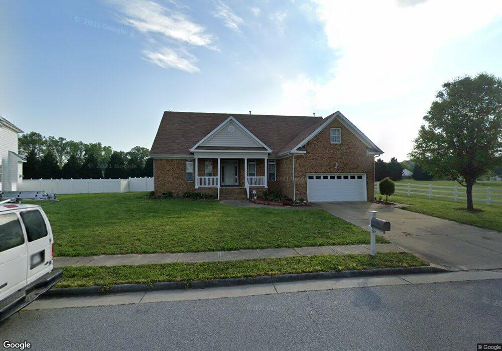
1111 Driver Pointe Ct Suffolk, VA 23435
Sleepy Hole NeighborhoodEstimated Value: $553,000 - $585,000
4
Beds
4
Baths
3,061
Sq Ft
$185/Sq Ft
Est. Value
About This Home
This home is located at 1111 Driver Pointe Ct, Suffolk, VA 23435 and is currently estimated at $566,364, approximately $185 per square foot. 1111 Driver Pointe Ct is a home located in Suffolk City with nearby schools including Driver Elementary School, John Yeates Middle School, and Nansemond River High School.
Ownership History
Date
Name
Owned For
Owner Type
Purchase Details
Closed on
Mar 16, 2015
Sold by
Federal National Mortgage Association
Bought by
Lawson Donecia S
Current Estimated Value
Home Financials for this Owner
Home Financials are based on the most recent Mortgage that was taken out on this home.
Original Mortgage
$276,000
Outstanding Balance
$209,446
Interest Rate
3.67%
Mortgage Type
New Conventional
Estimated Equity
$356,918
Purchase Details
Closed on
Dec 10, 2014
Sold by
Equity Trustees Llc Sub Tr
Bought by
Federal National Mortgage Association
Create a Home Valuation Report for This Property
The Home Valuation Report is an in-depth analysis detailing your home's value as well as a comparison with similar homes in the area
Home Values in the Area
Average Home Value in this Area
Purchase History
| Date | Buyer | Sale Price | Title Company |
|---|---|---|---|
| Lawson Donecia S | $299,000 | -- | |
| Federal National Mortgage Association | $318,027 | -- |
Source: Public Records
Mortgage History
| Date | Status | Borrower | Loan Amount |
|---|---|---|---|
| Open | Federal National Mortgage Association | $276,000 |
Source: Public Records
Tax History
| Year | Tax Paid | Tax Assessment Tax Assessment Total Assessment is a certain percentage of the fair market value that is determined by local assessors to be the total taxable value of land and additions on the property. | Land | Improvement |
|---|---|---|---|---|
| 2025 | $6,644 | $578,900 | $90,000 | $488,900 |
| 2024 | $6,644 | $501,100 | $85,000 | $416,100 |
| 2023 | $5,755 | $514,300 | $85,000 | $429,300 |
| 2022 | $4,890 | $448,600 | $85,000 | $363,600 |
| 2021 | $4,705 | $423,900 | $73,200 | $350,700 |
| 2020 | $4,599 | $414,300 | $73,200 | $341,100 |
| 2019 | $4,017 | $361,900 | $73,200 | $288,700 |
| 2018 | $4,035 | $364,300 | $73,200 | $291,100 |
| 2017 | $3,757 | $351,100 | $73,200 | $277,900 |
| 2016 | $3,757 | $351,100 | $73,200 | $277,900 |
| 2015 | $1,893 | $351,100 | $73,200 | $277,900 |
| 2014 | $1,893 | $362,000 | $73,200 | $288,800 |
Source: Public Records
Map
Nearby Homes
- 2231 Patrick Dr
- 2232 Patrick Dr
- 3003 Beech Grove Ln
- 2024 Canvasback Dr
- 2028 Canvasback Dr
- 2021 Canvasback Dr
- 1125 Erin Dr
- 1127 Erin Dr
- 1118 Erin Dr
- 1124 Erin Dr
- 1123 Erin Dr
- 1128 Erin Dr
- 3043 Dalton Cir
- 3041 Dalton Cir
- 3039 Dalton Cir
- 3030 Dalton Cir
- 3031 Dalton Cir
- 4500 Bennetts Pasture Rd
- 102 Foxcroft Rd
- 4364 Griffin Ln
- 1113 Driver Pointe Ct
- 1114 Driver Pointe Ct
- 1116 Driver Pointe Ct
- 1117 Driver Pointe Ct
- 1112 Driver Pointe Ct
- 1115 Driver Pointe Ct
- 1110 Driver Pointe Ct
- 1119 Driver Pointe Ct
- 1109 Driver Pointe Ct
- 2115 Canvasback Dr
- 2117 Canvasback Dr
- 2113 Canvasback Dr
- 1108 Driver Pointe Ct
- 1121 Driver Pointe Ct
- 3114 Driver Station Way
- 2111 Canvasback Dr
- 1107 Driver Pointe Ct
- 1106 Driver Pointe Ct
- 2109 Canvasback Dr
- 1123 Driver Pointe Ct
Your Personal Tour Guide
Ask me questions while you tour the home.