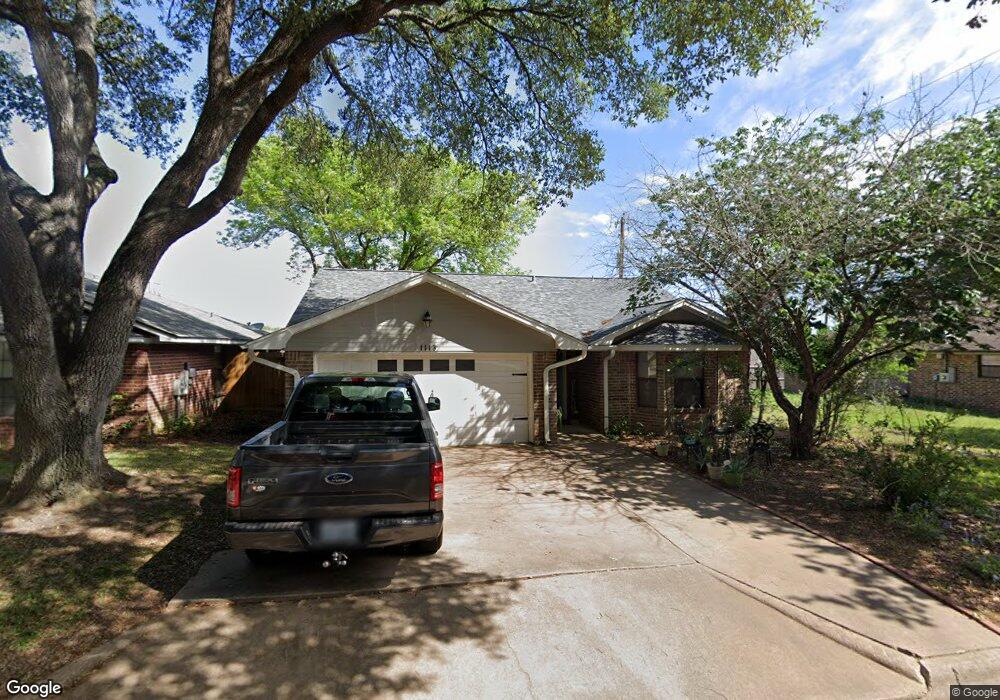
1113 Apache Dr Brenham, TX 77833
Estimated Value: $220,000 - $231,000
3
Beds
2
Baths
1,330
Sq Ft
$170/Sq Ft
Est. Value
About This Home
This home is located at 1113 Apache Dr, Brenham, TX 77833 and is currently estimated at $226,261, approximately $170 per square foot. 1113 Apache Dr is a home located in Washington County with nearby schools including Brenham High School, St. Paul's Christian Day School, and First Baptist Church School.
Ownership History
Date
Name
Owned For
Owner Type
Purchase Details
Closed on
Jan 19, 2026
Sold by
Moehlmann Jarred M and Moehlmann Katie
Bought by
Moehlmann Lori
Current Estimated Value
Purchase Details
Closed on
May 20, 2016
Sold by
Heilers Jeffery
Bought by
Moehlmann Jarred M
Home Financials for this Owner
Home Financials are based on the most recent Mortgage that was taken out on this home.
Original Mortgage
$95,950
Interest Rate
3.59%
Mortgage Type
New Conventional
Create a Home Valuation Report for This Property
The Home Valuation Report is an in-depth analysis detailing your home's value as well as a comparison with similar homes in the area
Purchase History
| Date | Buyer | Sale Price | Title Company |
|---|---|---|---|
| Moehlmann Lori | -- | None Listed On Document | |
| Moehlmann Jarred M | -- | None Available |
Source: Public Records
Mortgage History
| Date | Status | Borrower | Loan Amount |
|---|---|---|---|
| Previous Owner | Moehlmann Jarred M | $95,950 |
Source: Public Records
Tax History
| Year | Tax Paid | Tax Assessment Tax Assessment Total Assessment is a certain percentage of the fair market value that is determined by local assessors to be the total taxable value of land and additions on the property. | Land | Improvement |
|---|---|---|---|---|
| 2025 | $2,445 | $211,810 | $33,000 | $178,810 |
| 2024 | $3,140 | $207,970 | $33,000 | $174,970 |
| 2023 | $2,884 | $197,440 | $33,000 | $164,440 |
| 2022 | $2,914 | $184,710 | $33,000 | $151,710 |
| 2021 | $3,038 | $144,610 | $12,400 | $132,210 |
| 2020 | $2,793 | $132,060 | $12,290 | $119,770 |
| 2019 | $2,931 | $132,060 | $12,290 | $119,770 |
| 2018 | $2,753 | $124,070 | $10,710 | $113,360 |
| 2017 | $2,766 | $124,070 | $10,710 | $113,360 |
| 2016 | -- | $123,070 | $9,710 | $113,360 |
| 2015 | -- | $112,167 | $9,710 | $109,610 |
| 2014 | -- | $101,970 | $9,710 | $92,260 |
Source: Public Records
Map
Nearby Homes
- 2403 Cheyenne Dr
- 1202 Cheyenne Dr
- 2224 S Chappell Hill St
- 1304 Allison St
- 2511 S Market St
- 2305 Katherine St
- 1004 Lawndale Ave
- 1203 Hollis Dr
- 1608 Allison St
- 2701 S Market St
- 2439 Oak Hollow Ln
- 2435 Oak Hollow Ln
- 1400 Gun and Rod Rd
- 2433 Oak Hollow Ln
- 2416 Stone Hollow Dr
- 2398 Valley Dr
- 2315 Progress Dr
- 1803 Hickory Ln
- 2318 Progress Dr
- 2410 Oak Hollow Ln
- 1111 Apache Dr
- 2598 Cheyenne Dr
- 1109 Apache Dr
- 2596 Cheyenne Dr
- 1107 Apache Dr
- 2594 Cheyenne Dr
- 1112 Apache Dr
- 1110 Apache Dr
- 2600 Cheyenne Dr
- 1108 Apache Dr
- 1105 Apache Dr
- 2412 Cheyenne Dr
- 1106 Apache Dr
- 1203 Sioux Cir
- 1205 Sioux Cir
- 2599 Cheyenne Dr
- 1103 Apache Dr
- 2597 Cheyenne Dr
- 2601 Cheyenne Dr
- 2595 Cheyenne Dr
Your Personal Tour Guide
Ask me questions while you tour the home.