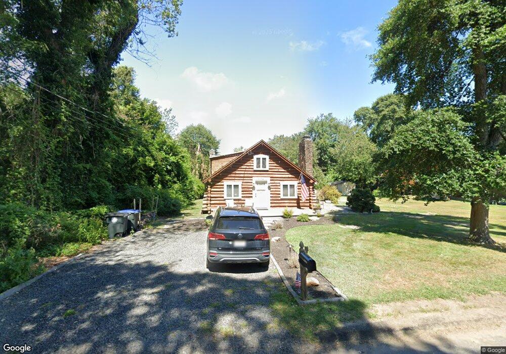
1114 Pine Rd Manasquan, NJ 08736
Estimated Value: $792,000 - $929,000
4
Beds
2
Baths
1,890
Sq Ft
$446/Sq Ft
Est. Value
About This Home
This home is located at 1114 Pine Rd, Manasquan, NJ 08736 and is currently estimated at $842,392, approximately $445 per square foot. 1114 Pine Rd is a home located in Monmouth County with nearby schools including Wall High School and The Brookside School.
Ownership History
Date
Name
Owned For
Owner Type
Purchase Details
Closed on
Feb 9, 2007
Sold by
Coloney John
Bought by
Ingoglia Anthony
Current Estimated Value
Home Financials for this Owner
Home Financials are based on the most recent Mortgage that was taken out on this home.
Original Mortgage
$252,000
Outstanding Balance
$151,524
Interest Rate
6.23%
Mortgage Type
Purchase Money Mortgage
Estimated Equity
$690,868
Create a Home Valuation Report for This Property
The Home Valuation Report is an in-depth analysis detailing your home's value as well as a comparison with similar homes in the area
Home Values in the Area
Average Home Value in this Area
Purchase History
We collect this data history from publicly available records. To have your information removed, we recommend requesting removal directly through your county’s website.
| Date | Buyer | Sale Price | Title Company |
|---|---|---|---|
| Ingoglia Anthony | $280,000 | -- |
Source: Public Records
Mortgage History
We collect this data history from publicly available records. To have your information removed, we recommend requesting removal directly through your county’s website.
| Date | Status | Borrower | Loan Amount |
|---|---|---|---|
| Open | Ingoglia Anthony | $252,000 |
Source: Public Records
Tax History
| Year | Tax Paid | Tax Assessment Tax Assessment Total Assessment is a certain percentage of the fair market value that is determined by local assessors to be the total taxable value of land and additions on the property. | Land | Improvement |
|---|---|---|---|---|
| 2025 | $7,284 | $345,200 | $206,900 | $138,300 |
| 2024 | $7,066 | $345,200 | $206,900 | $138,300 |
| 2023 | $7,066 | $345,200 | $206,900 | $138,300 |
| 2022 | $6,894 | $345,200 | $206,900 | $138,300 |
| 2021 | $6,894 | $345,200 | $206,900 | $138,300 |
| 2020 | $6,811 | $345,200 | $206,900 | $138,300 |
| 2019 | $6,728 | $345,200 | $206,900 | $138,300 |
| 2018 | $6,669 | $345,200 | $206,900 | $138,300 |
| 2017 | $6,538 | $345,200 | $206,900 | $138,300 |
| 2016 | $6,400 | $345,200 | $206,900 | $138,300 |
| 2015 | $6,251 | $211,900 | $114,000 | $97,900 |
| 2014 | $6,022 | $208,800 | $110,900 | $97,900 |
Source: Public Records
Map
Nearby Homes
- 87 Manito Rd
- 75 Narrumson Rd
- 1130 Mohegan Rd
- 100 Mohegan Rd
- 1219 Tecumseh Place
- 2555 Algonkin Trail
- 400 Lenape Trail
- 301 Old Bridge Rd
- 1238 Lakewood Rd
- 2548 Constance Dr
- 308 South St
- 640 Park Ave
- 2401 Fairview Dr
- 619 Park Ave
- 54 Curtis Ave
- 130 Union Ave
- 11 Pearce Ave
- 13 Pearce Ave
- 5 Berkeley Square
- 543 Harris Ave
- 1112 Minnehaha Trail
- 1116 Minnehaha Trail
- 1106 Minnehaha Trail
- 1115 Manito Rd
- 1113 Minnehaha Trail
- 1107 Manito Rd
- 1117 Manito Rd
- 1109 Minnehaha Trail
- 1117 Minnehaha Trail
- 1118 Minnehaha Trail
- 1104 Minnehaha Trail
- 1119 Manito Rd
- 1105 Manito Rd
- 1119 Minnehaha Trail
- 1121 Manito Rd
- 1112 Manito Rd
- 1116 Manito Rd
- 1112 Pine Rd
- 1110 Pine Rd
- 1106 Manito Rd
Your Personal Tour Guide
Ask me questions while you tour the home.