Estimated Value: $329,420 - $472,000
3
Beds
2
Baths
2,888
Sq Ft
$131/Sq Ft
Est. Value
About This Home
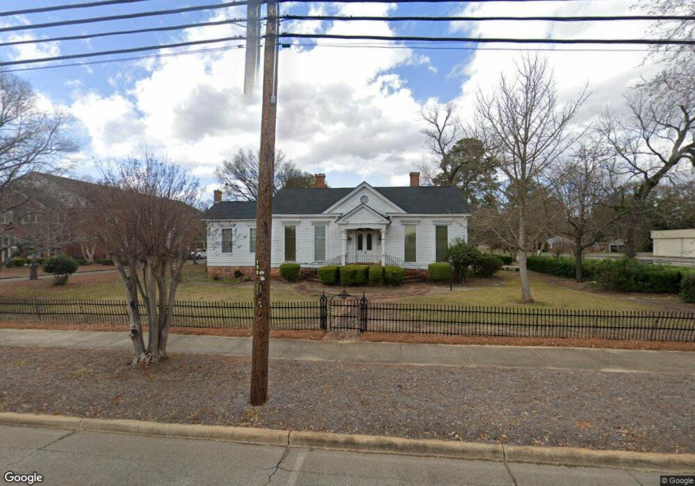
This home is located at 1117 Main St, Perry, GA 31069 and is currently estimated at $377,355, approximately $130 per square foot. 1117 Main St is a home located in Houston County with nearby schools including Morningside Elementary School, Perry Middle School, and Perry High School.
Ownership History
Date
Name
Owned For
Owner Type
Purchase Details
Closed on
Apr 15, 2015
Sold by
Gayle Joe A
Bought by
First Baptist Church Of Perry
Current Estimated Value
Purchase Details
Closed on
Apr 8, 2008
Sold by
Gayle Richard R and Gayle Connette R
Bought by
Gayle Joe A
Purchase Details
Closed on
Apr 30, 1983
Sold by
Gayle Joe A
Bought by
Gayle Joe A and Gayle Connette R
Purchase Details
Closed on
May 26, 1962
Bought by
Gayle Joe A
Purchase Details
Closed on
May 9, 1949
Bought by
Warren Edward M
Create a Home Valuation Report for This Property
The Home Valuation Report is an in-depth analysis detailing your home's value as well as a comparison with similar homes in the area
Home Values in the Area
Average Home Value in this Area
Purchase History
| Date | Buyer | Sale Price | Title Company |
|---|---|---|---|
| First Baptist Church Of Perry | $240,000 | -- | |
| Gayle Joe A | -- | None Available | |
| Gayle Joe A | -- | -- | |
| Gayle Joe A | -- | -- | |
| Warren Edward M | -- | -- |
Source: Public Records
Tax History
| Year | Tax Paid | Tax Assessment Tax Assessment Total Assessment is a certain percentage of the fair market value that is determined by local assessors to be the total taxable value of land and additions on the property. | Land | Improvement |
|---|---|---|---|---|
| 2025 | -- | $80,440 | $9,000 | $71,440 |
| 2024 | -- | $88,040 | $17,600 | $70,440 |
| 2023 | $2,700 | $75,120 | $17,600 | $57,520 |
| 2022 | $2,700 | $73,000 | $17,600 | $55,400 |
| 2021 | $2,556 | $68,440 | $17,600 | $50,840 |
| 2020 | $2,491 | $66,720 | $17,600 | $49,120 |
| 2019 | $2,491 | $66,720 | $17,600 | $49,120 |
| 2018 | $0 | $66,720 | $17,600 | $49,120 |
| 2017 | $0 | $66,720 | $17,600 | $49,120 |
| 2016 | $657 | $66,720 | $17,600 | $49,120 |
| 2015 | $2,033 | $87,120 | $14,800 | $72,320 |
| 2014 | -- | $52,520 | $9,880 | $42,640 |
| 2013 | -- | $52,520 | $9,880 | $42,640 |
Source: Public Records
Map
Nearby Homes
- 0 Carroll Aly
- 1205 Swift St
- 202 Farrell Way
- 207 Farrell Way
- 107 Pridgen Pass
- 100 Pridgen Pass
- 118 Pridgen Pass
- 119 Pridgen Pass
- 205 Farrell Way
- 101 Red Cedar Run
- 102 Dawson Wyatt Ct
- 106 Cassandra Ann Way
- 625 Cooper St
- 624 Pine Ridge St
- 614 Hillcrest Ave
- 1512 State St
- 1418 Parkway Dr
- 411 Stonegate Trail
- 415 Stonegate Trail
- 202 Martin Luther King jr Dr
- 1005 2nd St
- 1005 S 2nd St
- 1006 2nd St
- 1006 S 2nd St
- 1008 2nd St
- 1006 1st St
- 1204 Swift St
- 1200 Swift St
- 1212 Main St
- 0 Houston Lake Dr Unit 3165807
- 1211 Houston Lake Dr
- 1214 Main St
- 1001 3rd St
- 1007 1st St
- 1107 2nd St Unit . 2
- 1107 2nd St Unit . 1
- 1208 Swift St
- 1005 3rd St
- 1007 1/2 3rd St
- 1216 Main St
Your Personal Tour Guide
Ask me questions while you tour the home.