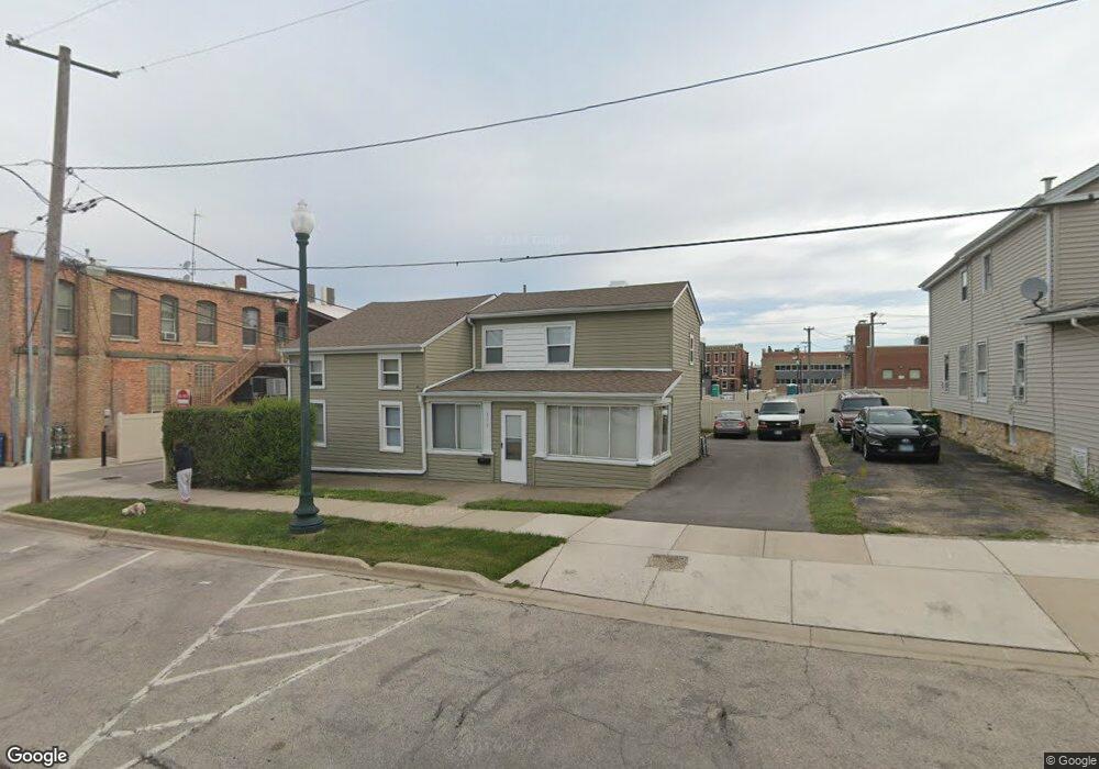
112 E 11th St Lockport, IL 60441
Estimated Value: $267,951 - $423,000
Studio
--
Bath
1,927
Sq Ft
$167/Sq Ft
Est. Value
About This Home
This home is located at 112 E 11th St, Lockport, IL 60441 and is currently estimated at $322,738, approximately $167 per square foot. 112 E 11th St is a home located in Will County with nearby schools including Milne Grove Elementary School, Kelvin Grove Jr High School, and Lockport Township High School East.
Ownership History
Date
Name
Owned For
Owner Type
Purchase Details
Closed on
Sep 23, 2021
Sold by
Chicago Title Land Trust Company
Bought by
The Richard And Brenda Family Trust
Current Estimated Value
Purchase Details
Closed on
Jul 1, 2002
Sold by
D & H Property Management Company Llc
Bought by
Harris Bank Joliet Na and Trust #4048
Purchase Details
Closed on
Nov 1, 2000
Sold by
Schmidt Ronald F and Schmidt Deborah D
Bought by
D & H Property Management Company Llc
Create a Home Valuation Report for This Property
The Home Valuation Report is an in-depth analysis detailing your home's value as well as a comparison with similar homes in the area
Home Values in the Area
Average Home Value in this Area
Purchase History
| Date | Buyer | Sale Price | Title Company |
|---|---|---|---|
| The Richard And Brenda Family Trust | -- | Chicago Title Land Trust Co | |
| Harris Bank Joliet Na | $80,000 | -- | |
| D & H Property Management Company Llc | -- | -- |
Source: Public Records
Tax History
| Year | Tax Paid | Tax Assessment Tax Assessment Total Assessment is a certain percentage of the fair market value that is determined by local assessors to be the total taxable value of land and additions on the property. | Land | Improvement |
|---|---|---|---|---|
| 2024 | $7,282 | $84,815 | $18,364 | $66,451 |
| 2023 | $7,282 | $76,142 | $16,486 | $59,656 |
| 2022 | $6,539 | $71,026 | $15,378 | $55,648 |
| 2021 | $6,221 | $66,748 | $14,452 | $52,296 |
| 2020 | $6,077 | $64,553 | $13,977 | $50,576 |
| 2019 | $5,794 | $61,187 | $13,248 | $47,939 |
| 2018 | $5,488 | $56,565 | $12,248 | $44,317 |
| 2017 | $5,102 | $51,344 | $11,117 | $40,227 |
| 2016 | $4,828 | $47,363 | $10,255 | $37,108 |
| 2015 | $3,914 | $37,173 | $9,119 | $28,054 |
| 2014 | $3,914 | $35,743 | $8,768 | $26,975 |
| 2013 | $3,914 | $36,473 | $8,947 | $27,526 |
Source: Public Records
Map
Nearby Homes
- 1016 S State St
- 118 E 11th St
- 1100 S State St
- 1120 S Hamilton St
- 1200 S State St
- 316 E 13th St
- 1112 S Jefferson St
- 500 Clinton St
- 1709 S State St
- 136 W 18th St
- 1509 East St Unit ST1511
- 1505 East St
- 107 S State St
- 120 N State St
- 118 N State St
- 2005 Princess Ct
- 2009 Princess Ct
- 2021 Princess Ct
- 1212 Grandview Ave
- 752 Rosanne St
- 1028 S State St Unit 2
- 1028 S State St
- 1028 S State St Unit 2N
- 1028 S State St Unit 4
- 122 E 11th St
- 1026 S State St
- 1026 S State St Unit LL
- 1026 S State St Unit LL-SO
- 1026 S State St Unit LL-NO
- 1026 S State St Unit 2S
- 1022 S State St Unit 1022
- 124 E 11th St
- 1016 S State St Unit 3
- 1016 S State St Unit 2
- 1016 S State St Unit 4
- 1016 S State St Unit 1
- 117 E 11th St
- 1020 S State St Unit 2F
- 1020 S State St Unit 1REAR
- 1020 S State St Unit 1020
Your Personal Tour Guide
Ask me questions while you tour the home.