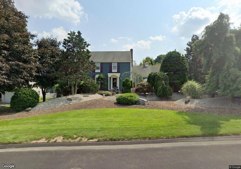
112 Goff Brook Cir Wethersfield, CT 06109
Estimated Value: $535,000 - $583,000
4
Beds
3
Baths
2,262
Sq Ft
$247/Sq Ft
Est. Value
About This Home
This home is located at 112 Goff Brook Cir, Wethersfield, CT 06109 and is currently estimated at $558,759, approximately $247 per square foot. 112 Goff Brook Cir is a home located in Hartford County with nearby schools including Highcrest School, Silas Deane Middle School, and Wethersfield High School.
Ownership History
Date
Name
Owned For
Owner Type
Purchase Details
Closed on
Mar 18, 2025
Sold by
Lionetti Diana P
Bought by
Lionetti Ft and Votino
Current Estimated Value
Purchase Details
Closed on
Dec 15, 1997
Sold by
Boornazian Marion S
Bought by
Lionetti David C and Lionetti Diana P
Create a Home Valuation Report for This Property
The Home Valuation Report is an in-depth analysis detailing your home's value as well as a comparison with similar homes in the area
Home Values in the Area
Average Home Value in this Area
Purchase History
| Date | Buyer | Sale Price | Title Company |
|---|---|---|---|
| Lionetti Ft | -- | None Available | |
| Lionetti Ft | -- | None Available | |
| Lionetti David C | $270,000 | -- | |
| Lionetti David C | $270,000 | -- |
Source: Public Records
Mortgage History
| Date | Status | Borrower | Loan Amount |
|---|---|---|---|
| Previous Owner | Lionetti David C | $110,000 | |
| Previous Owner | Lionetti David C | $50,000 | |
| Previous Owner | Lionetti David C | $300,000 |
Source: Public Records
Tax History
| Year | Tax Paid | Tax Assessment Tax Assessment Total Assessment is a certain percentage of the fair market value that is determined by local assessors to be the total taxable value of land and additions on the property. | Land | Improvement |
|---|---|---|---|---|
| 2025 | $15,392 | $373,410 | $112,840 | $260,570 |
| 2024 | $10,147 | $234,770 | $87,810 | $146,960 |
| 2023 | $9,809 | $234,770 | $87,810 | $146,960 |
| 2022 | $9,644 | $234,770 | $87,810 | $146,960 |
| 2021 | $9,548 | $234,770 | $87,810 | $146,960 |
| 2020 | $9,553 | $234,770 | $87,800 | $146,970 |
| 2019 | $9,565 | $234,770 | $87,800 | $146,970 |
| 2018 | $9,114 | $223,500 | $86,900 | $136,600 |
| 2017 | $8,889 | $223,500 | $86,900 | $136,600 |
| 2016 | $8,614 | $223,500 | $86,900 | $136,600 |
| 2015 | $8,535 | $223,500 | $86,900 | $136,600 |
| 2014 | $8,186 | $222,800 | $86,900 | $135,900 |
Source: Public Records
Map
Nearby Homes
- 155 Old Common Rd
- 34 Rose Ct
- 25 Heather Hill
- 268 Fox Hill Rd
- 5 Westmont Rd
- 170 Whitewood Dr
- 238 Two Rod Hwy
- 6 Vinnie Dr
- 61 Luca Ln
- 76 Luca Lane Homesite 8
- 101 Collier Rd
- 993 Cloverdale Cir
- 332 Cypress Rd Unit 332
- 36 Copper Beech Dr
- 20 Little Oak Ln Unit 20
- 9 Dogwood Ct
- 35 Woodsedge Dr Unit 4C
- 35 Woodsedge Dr Unit 3C
- 519 Prospect St
- 42 Dunham St
- 98 Goff Brook Cir
- 411 Hang Dog Ln
- 116 Goff Brook Cir
- 423 Hang Dog Ln
- 107 Goff Brook Cir
- 111 Goff Brook Cir
- 99 Goff Brook Cir
- 88 Goff Brook Cir
- 121 Goff Brook Cir
- 410 Hang Dog Ln
- 612 Highland St
- 604 Highland St
- 89 Goff Brook Cir
- 24 Deer Ledge Ln
- 402 Hang Dog Ln
- 16 Deer Ledge Ln
- 78 Goff Brook Cir
- 594 Highland St
- 628 Highland St
- 34 Deer Ledge Ln
Your Personal Tour Guide
Ask me questions while you tour the home.