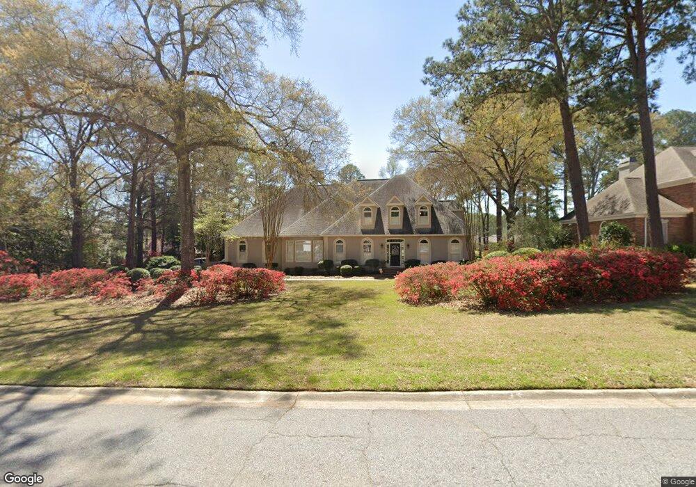
112 Stathams Way Warner Robins, GA 31088
Estimated Value: $518,977 - $571,000
4
Beds
4
Baths
4,313
Sq Ft
$127/Sq Ft
Est. Value
About This Home
This home is located at 112 Stathams Way, Warner Robins, GA 31088 and is currently estimated at $545,994, approximately $126 per square foot. 112 Stathams Way is a home located in Houston County with nearby schools including Bonaire Elementary School, Huntington Middle School, and Warner Robins High School.
Ownership History
Date
Name
Owned For
Owner Type
Purchase Details
Closed on
Aug 17, 2009
Sold by
Livingston Michael S
Bought by
Stembridge Katherine and Stembridge David
Current Estimated Value
Purchase Details
Closed on
Oct 30, 1998
Sold by
Residential Funding Corp
Bought by
Livingston Michael S
Purchase Details
Closed on
May 5, 1998
Sold by
Jett Scot M
Bought by
Residential Funding Corp
Purchase Details
Closed on
Jul 5, 1995
Sold by
Lashley Gary and Rebecca J*
Bought by
Jett Scot M
Purchase Details
Closed on
Aug 19, 1988
Sold by
Thompson Wessie D
Bought by
Lashley Gary and Rebecca J*
Purchase Details
Closed on
Jul 21, 1987
Sold by
Stathams Landing Co
Bought by
Thompson Wessie D
Create a Home Valuation Report for This Property
The Home Valuation Report is an in-depth analysis detailing your home's value as well as a comparison with similar homes in the area
Home Values in the Area
Average Home Value in this Area
Purchase History
| Date | Buyer | Sale Price | Title Company |
|---|---|---|---|
| Stembridge Katherine | -- | None Available | |
| Livingston Michael S | $277,600 | -- | |
| Residential Funding Corp | $255,400 | -- | |
| Jett Scot M | $311,000 | -- | |
| Lashley Gary | -- | -- | |
| Thompson Wessie D | -- | -- |
Source: Public Records
Tax History
| Year | Tax Paid | Tax Assessment Tax Assessment Total Assessment is a certain percentage of the fair market value that is determined by local assessors to be the total taxable value of land and additions on the property. | Land | Improvement |
|---|---|---|---|---|
| 2025 | $4,023 | $186,480 | $16,800 | $169,680 |
| 2024 | $4,397 | $185,800 | $16,800 | $169,000 |
| 2023 | $3,715 | $155,720 | $16,800 | $138,920 |
| 2022 | $3,342 | $140,280 | $16,800 | $123,480 |
| 2021 | $3,155 | $131,880 | $16,800 | $115,080 |
| 2020 | $3,089 | $128,560 | $16,800 | $111,760 |
| 2019 | $3,089 | $128,560 | $16,800 | $111,760 |
| 2018 | $3,089 | $128,560 | $16,800 | $111,760 |
| 2017 | $3,092 | $128,560 | $16,800 | $111,760 |
| 2016 | $3,097 | $128,560 | $16,800 | $111,760 |
| 2015 | $3,103 | $128,560 | $16,800 | $111,760 |
| 2014 | -- | $129,320 | $16,800 | $112,520 |
| 2013 | -- | $129,320 | $16,800 | $112,520 |
Source: Public Records
Map
Nearby Homes
- 104 Bunkers Trail
- 201 Stathams Way
- 108 Falcon Crest
- 108 Bunkers Trail
- 215 Falcon Crest
- 256 Falcon Crest Unit STATHAMS LANDING
- 215 Falcon Crest Unit Stathams Landing
- 256 Falcon Crest
- 125 Bunkers Trail
- 106 Club Ct
- 226 Landings Pointe Ln
- 107 Deerwood Dr
- 109 Crest Pointe
- 100 Club Place Ct
- 602 Charlestown Way
- 601 Charlestown Way
- 105 Sandy Pointe Dr
- 212 Falcon Crest
- 314 Apalachee Way
- 114 Hampton Pointe
Your Personal Tour Guide
Ask me questions while you tour the home.