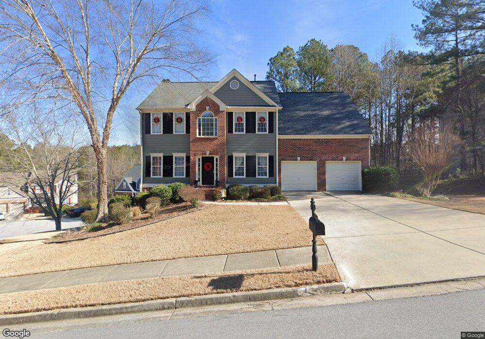
112 Thunder Ridge Dr Acworth, GA 30101
Cedarcrest NeighborhoodEstimated Value: $416,000 - $478,000
3
Beds
3
Baths
2,375
Sq Ft
$188/Sq Ft
Est. Value
About This Home
This home is located at 112 Thunder Ridge Dr, Acworth, GA 30101 and is currently estimated at $446,153, approximately $187 per square foot. 112 Thunder Ridge Dr is a home located in Paulding County with nearby schools including Burnt Hickory Elementary School, Sammy Mcclure Sr. Middle School, and North Paulding High School.
Ownership History
Date
Name
Owned For
Owner Type
Purchase Details
Closed on
Sep 29, 2022
Sold by
Degrange Jamie
Bought by
Bean Michael and Rice Nasheta
Current Estimated Value
Home Financials for this Owner
Home Financials are based on the most recent Mortgage that was taken out on this home.
Original Mortgage
$366,208
Outstanding Balance
$346,395
Interest Rate
4.62%
Mortgage Type
FHA
Estimated Equity
$99,758
Purchase Details
Closed on
Apr 20, 2006
Sold by
Vail John D and Vail Stephanie K
Bought by
Renteria Roland R and Renteria Christine A
Purchase Details
Closed on
Sep 21, 2000
Sold by
Four Star Residential
Purchase Details
Closed on
Dec 22, 1999
Sold by
Cousins Real Estate Corp
Create a Home Valuation Report for This Property
The Home Valuation Report is an in-depth analysis detailing your home's value as well as a comparison with similar homes in the area
Home Values in the Area
Average Home Value in this Area
Purchase History
| Date | Buyer | Sale Price | Title Company |
|---|---|---|---|
| Bean Michael | $399,900 | -- | |
| Renteria Roland R | $251,500 | -- | |
| -- | $180,400 | -- | |
| -- | $28,500 | -- |
Source: Public Records
Mortgage History
| Date | Status | Borrower | Loan Amount |
|---|---|---|---|
| Open | Bean Michael | $366,208 |
Source: Public Records
Tax History
| Year | Tax Paid | Tax Assessment Tax Assessment Total Assessment is a certain percentage of the fair market value that is determined by local assessors to be the total taxable value of land and additions on the property. | Land | Improvement |
|---|---|---|---|---|
| 2025 | $4,333 | $181,432 | $26,000 | $155,432 |
| 2024 | $4,055 | $166,236 | $26,000 | $140,236 |
| 2023 | $4,462 | $173,680 | $26,000 | $147,680 |
| 2022 | $3,922 | $152,308 | $26,000 | $126,308 |
| 2021 | $3,538 | $123,600 | $26,000 | $97,600 |
| 2020 | $3,167 | $108,480 | $26,000 | $82,480 |
| 2019 | $3,063 | $103,508 | $26,000 | $77,508 |
| 2018 | $3,072 | $103,840 | $26,000 | $77,840 |
| 2017 | $2,818 | $94,120 | $26,000 | $68,120 |
| 2016 | $2,878 | $97,040 | $26,000 | $71,040 |
| 2015 | $2,508 | $83,360 | $26,000 | $57,360 |
| 2014 | $2,532 | $82,080 | $26,000 | $56,080 |
| 2013 | -- | $74,800 | $26,000 | $48,800 |
Source: Public Records
Map
Nearby Homes
- 28 McEvers Branch Ct
- 365 Hunt Creek Dr
- 103 Brier Bend Ct Unit D
- 131 Brier Bend Ct
- 434 Hunt Creek Dr
- 385 Graves Rd
- 451 Graves Rd
- 88 Water Oak Dr
- 31 Evening Mist Dr
- 198 Hickory Pointe Dr
- 283 Hickory Pointe Dr
- 1139 Lost Creek Pkwy
- 81 Buckthorn Way
- 228 Fairway Overlook Dr
- 1065 Lost Creek Pkwy
- 74 Buckthorn Way
- 1046 Lost Creek Pkwy
- 1648 Harmony Grove Church Rd
- 62 Cleburne Place
- 88 Cool Creek Ct
- 18 Creek Branch Ct
- 109 Thunder Ridge Dr
- 80 Thunder Ridge Dr
- 97 Thunder Ridge Dr
- 127 Thunder Ridge Dr
- 22 Creek Branch Ct
- 25 Creek Branch Ct Unit A
- 62 Thunder Ridge Dr
- 19 Creek Branch Ct
- 85 Thunder Ridge Dr
- 11 Creek Branch Ct Unit A
- 145 Thunder Ridge Dr
- 71 Thunder Ridge Dr
- 71 Thunder Ridge Dr
- 163 Thunder Ridge Dr
- 57 Thunder Ridge Dr
- 46 Thunder Ridge Dr
- 65 Newcomb Trace
- 179 Thunder Ridge Dr Unit A
- 33 Thunder Ridge Dr
Your Personal Tour Guide
Ask me questions while you tour the home.