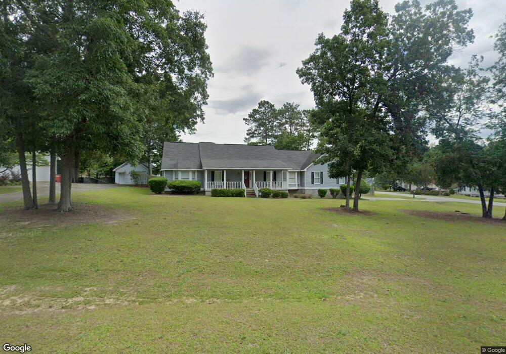
114 Heath Dr S Macon, GA 31220
Estimated Value: $230,000 - $256,000
3
Beds
2
Baths
1,868
Sq Ft
$128/Sq Ft
Est. Value
About This Home
This home is located at 114 Heath Dr S, Macon, GA 31220 and is currently estimated at $240,037, approximately $128 per square foot. 114 Heath Dr S is a home located in Bibb County with nearby schools including Union Elementary School, Weaver Middle School, and Westside High School.
Ownership History
Date
Name
Owned For
Owner Type
Purchase Details
Closed on
Aug 7, 2006
Sold by
Federal National Morgage Assn
Bought by
Mitchell Chanin A
Current Estimated Value
Home Financials for this Owner
Home Financials are based on the most recent Mortgage that was taken out on this home.
Original Mortgage
$125,000
Outstanding Balance
$74,064
Interest Rate
6.71%
Mortgage Type
New Conventional
Estimated Equity
$165,973
Purchase Details
Closed on
Apr 4, 2006
Home Financials for this Owner
Home Financials are based on the most recent Mortgage that was taken out on this home.
Original Mortgage
$119,700
Interest Rate
6.29%
Mortgage Type
Purchase Money Mortgage
Purchase Details
Closed on
Feb 28, 2003
Purchase Details
Closed on
Feb 27, 1998
Create a Home Valuation Report for This Property
The Home Valuation Report is an in-depth analysis detailing your home's value as well as a comparison with similar homes in the area
Purchase History
| Date | Buyer | Sale Price | Title Company |
|---|---|---|---|
| Mitchell Chanin A | -- | Not Available | |
| -- | $121,500 | -- | |
| Federal National Mortgage Association | $121,490 | None Available | |
| -- | $126,000 | -- | |
| -- | $107,000 | -- |
Source: Public Records
Mortgage History
| Date | Status | Borrower | Loan Amount |
|---|---|---|---|
| Open | Mitchell Chanin A | $125,000 | |
| Previous Owner | Federal National Mortgage Association | $119,700 |
Source: Public Records
Tax History
| Year | Tax Paid | Tax Assessment Tax Assessment Total Assessment is a certain percentage of the fair market value that is determined by local assessors to be the total taxable value of land and additions on the property. | Land | Improvement |
|---|---|---|---|---|
| 2025 | $1,795 | $80,036 | $10,000 | $70,036 |
| 2024 | $1,855 | $80,036 | $10,000 | $70,036 |
| 2023 | $1,166 | $70,901 | $10,000 | $60,901 |
| 2022 | $1,616 | $53,691 | $6,456 | $47,235 |
| 2021 | $1,565 | $48,193 | $6,162 | $42,031 |
| 2020 | $1,599 | $48,193 | $6,162 | $42,031 |
| 2019 | $1,433 | $48,193 | $6,162 | $42,031 |
| 2018 | $2,560 | $46,708 | $5,869 | $40,839 |
| 2017 | $1,488 | $46,708 | $5,869 | $40,839 |
| 2016 | $1,374 | $46,708 | $5,869 | $40,839 |
| 2015 | $1,945 | $46,708 | $5,869 | $40,839 |
| 2014 | $2,413 | $56,193 | $13,205 | $42,988 |
Source: Public Records
Map
Nearby Homes
- 101 George Oxford Dr
- 506 Pine Meadows Ct
- 311 Shannon Ct
- 306 Shannon Ct
- 313 Shannon Ct
- 308 Shannon Ct
- 310 Shannon Ct
- 304 Shannon Ct
- 224 Carsons Walk
- 229 Carsons Walk
- 219 Carsons Walk
- 177 Kinsale Dr
- 177 Kinsale Dr
- 211 Kinsale Dr
- 213 Kinsale Dr
- 209 Kinsale Dr
- 205 Kinsale Dr
- 203 Kinsale Dr
- 201 Kinsale Dr
- 203 Kinsale Dr
- 110 Heath Dr S
- 130 Heath Dr S
- 205 Hickory Ct
- 111 Heath Dr S
- 123 Heath Dr S
- 127 Heath Dr S
- 109 Heath Dr S
- 109 Heath Dr S Unit 42/4
- 115 Heath Dr S
- 106 Heath Dr S
- S Heath Dr S
- 209 Hickory Ct
- 131 Heath Dr S
- 131 Heath Dr S Unit 42
- 119 Heath Dr S
- 107 Heath Dr S
- 200 Hickory Ct
- 2728 Heath Rd
- 115 Heath Pl Rd
- 135 Heath Dr S
Your Personal Tour Guide
Ask me questions while you tour the home.