
Seller's Agent in 2025
Laura Baliestiero
Coldwell Banker Realty - Concord
(508) 864-6011
26 in this area
416 Total Sales
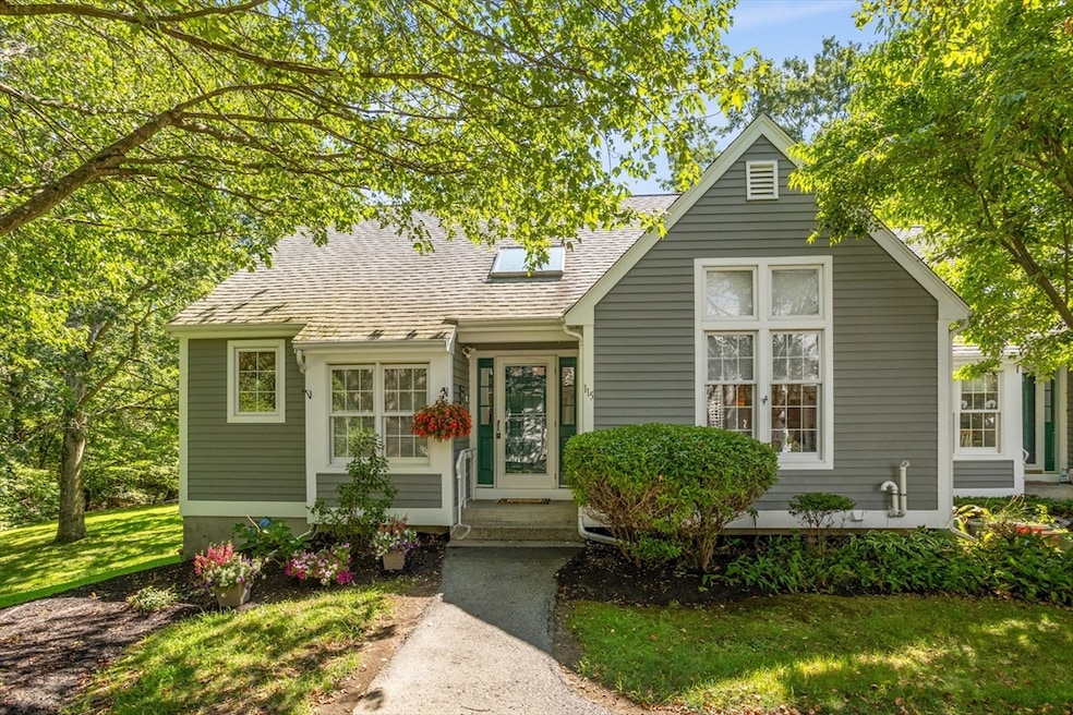


Sunday Open House Cancelled! Wonderful opportunity to own a beautifully maintained townhouse in desirable Audubon Hill North, a 55+ community with clubhouse & tennis court, next to the serene Pratts Brook Conservation Area. Quality one level living at its best, with a bright foyer as you enter, that opens into a brilliant cathedral living room/dining room area with bump out windows and a finished enclosed porch area, for extra year-round living space. Tiled kitchen with a large opening to see into the dining space. Primary bedroom has a full bath, standing shower, and walk-in closet. The second bedroom is great for guests or in-home office. The lower-level offers a large living space with lots of use possibilities, huge walk-in closet and storage. Lower level walks out to a lovely private patio. Heat, A/C and electrical have been recently updated. One car detached garage with storage and deeded parking spot included. Minutes, from shops, restaurants and MBTA train station.
Last Agent to Sell the Property
Coldwell Banker Realty - Concord Listed on: 07/23/2025
| Date | Type | Sale Price | Title Company |
|---|---|---|---|
| Quit Claim Deed | $575,000 | -- | |
| Deed | $575,000 | -- | |
| Deed | -- | -- | |
| Deed | -- | -- | |
| Deed | -- | -- | |
| Deed | $228,000 | -- | |
| Deed | $228,000 | -- | |
| Deed | $220,800 | -- | |
| Deed | $220,800 | -- | |
| Deed | $197,000 | -- | |
| Deed | $197,000 | -- |
| Date | Status | Loan Amount | Loan Type |
|---|---|---|---|
| Previous Owner | $50,000 | Purchase Money Mortgage |
| Date | Event | Price | List to Sale | Price per Sq Ft |
|---|---|---|---|---|
| 08/22/2025 08/22/25 | Sold | $575,000 | +4.7% | $295 / Sq Ft |
| 07/26/2025 07/26/25 | Pending | -- | -- | -- |
| 07/23/2025 07/23/25 | For Sale | $549,000 | -- | $282 / Sq Ft |
| Year | Tax Paid | Tax Assessment Tax Assessment Total Assessment is a certain percentage of the fair market value that is determined by local assessors to be the total taxable value of land and additions on the property. | Land | Improvement |
|---|---|---|---|---|
| 2025 | $8,644 | $504,000 | $0 | $504,000 |
| 2024 | $6,801 | $408,000 | $0 | $408,000 |
| 2023 | $6,666 | $379,600 | $0 | $379,600 |
| 2022 | $7,510 | $386,100 | $0 | $386,100 |
| 2021 | $7,176 | $354,700 | $0 | $354,700 |
| 2020 | $6,938 | $360,600 | $0 | $360,600 |
| 2019 | $7,109 | $367,000 | $0 | $367,000 |
| 2018 | $6,758 | $348,700 | $0 | $348,700 |
| 2017 | $6,084 | $319,200 | $0 | $319,200 |
| 2016 | $5,377 | $279,600 | $0 | $279,600 |
| 2015 | $5,351 | $280,900 | $0 | $280,900 |
| 2014 | $4,748 | $244,100 | $0 | $244,100 |
Seller's Agent in 2025
Laura Baliestiero
Coldwell Banker Realty - Concord
(508) 864-6011
26 in this area
416 Total Sales
B
Seller Co-Listing Agent in 2025
Barry Dyment
Coldwell Banker Realty - Concord
(781) 389-7431
8 in this area
68 Total Sales
Buyer's Agent in 2025
Ann Erickson Shaw
Keller Williams Realty Boston Northwest
(978) 273-1963
36 in this area
62 Total Sales
Source: MLS Property Information Network (MLS PIN)
MLS Number: 73408169
APN: ACTO-000003AH000059-000115
Disclaimer: Certain information contained herein is derived from information provided by parties other than Homes.com. All information provided is deemed reliable, but is not guaranteed to be accurate and should be independently verified.
![]() The property listing data and information, or the Images, set forth herein were provided to MLS Property Information Network, Inc. from third party sources, including sellers, lessors and public records, and were compiled by MLS Property Information Network, Inc. The property listing data and information, and the Images, are for the personal, non-commercial use of consumers having a good faith interest in purchasing or leasing listed properties of the type displayed to them and may not be used for any purpose other than to identify prospective properties which such consumers may have a good faith interest in purchasing or leasing. MLS Property Information Network, Inc. and its subscribers disclaim any and all representations and warranties as to the accuracy of the property listing data and information, or as to the accuracy of any of the Images, set forth herein.
The property listing data and information, or the Images, set forth herein were provided to MLS Property Information Network, Inc. from third party sources, including sellers, lessors and public records, and were compiled by MLS Property Information Network, Inc. The property listing data and information, and the Images, are for the personal, non-commercial use of consumers having a good faith interest in purchasing or leasing listed properties of the type displayed to them and may not be used for any purpose other than to identify prospective properties which such consumers may have a good faith interest in purchasing or leasing. MLS Property Information Network, Inc. and its subscribers disclaim any and all representations and warranties as to the accuracy of the property listing data and information, or as to the accuracy of any of the Images, set forth herein.
Ask me questions while you tour the home.