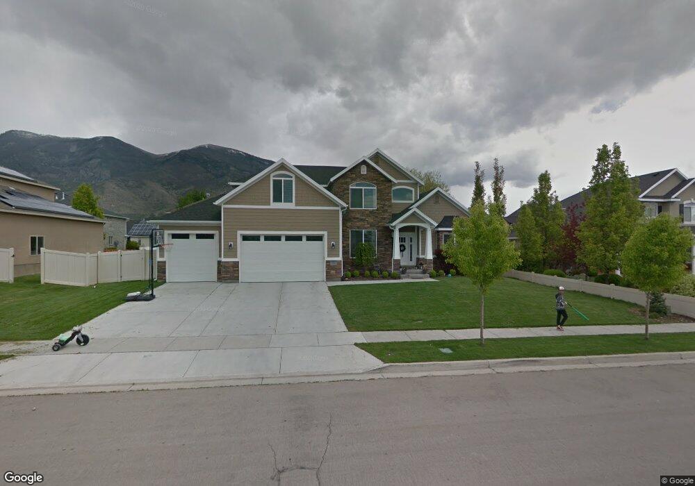
1154 N 1100 E American Fork, UT 84003
Estimated Value: $841,272 - $885,000
4
Beds
3
Baths
4,290
Sq Ft
$200/Sq Ft
Est. Value
About This Home
This home is located at 1154 N 1100 E, American Fork, UT 84003 and is currently estimated at $858,068, approximately $200 per square foot. 1154 N 1100 E is a home located in Utah County with nearby schools including Deerfield Elementary School, Mountain Ridge Junior High School, and American Fork High School.
Ownership History
Date
Name
Owned For
Owner Type
Purchase Details
Closed on
Aug 29, 2012
Sold by
Carlisle Holdings Company Llc
Bought by
Terry Matthew and Terry Angela
Current Estimated Value
Home Financials for this Owner
Home Financials are based on the most recent Mortgage that was taken out on this home.
Original Mortgage
$286,400
Outstanding Balance
$197,428
Interest Rate
3.49%
Mortgage Type
New Conventional
Estimated Equity
$660,640
Purchase Details
Closed on
Apr 15, 2005
Sold by
Hunsaker Glen U and Hunsaker Kay M
Bought by
Carlisle Holdings Co Llc
Create a Home Valuation Report for This Property
The Home Valuation Report is an in-depth analysis detailing your home's value as well as a comparison with similar homes in the area
Home Values in the Area
Average Home Value in this Area
Purchase History
| Date | Buyer | Sale Price | Title Company |
|---|---|---|---|
| Terry Matthew | -- | None Available | |
| Carlisle Holdings Co Llc | -- | Merrill Title Company |
Source: Public Records
Mortgage History
| Date | Status | Borrower | Loan Amount |
|---|---|---|---|
| Open | Terry Matthew | $286,400 |
Source: Public Records
Tax History
| Year | Tax Paid | Tax Assessment Tax Assessment Total Assessment is a certain percentage of the fair market value that is determined by local assessors to be the total taxable value of land and additions on the property. | Land | Improvement |
|---|---|---|---|---|
| 2025 | $3,404 | $420,035 | -- | -- |
| 2024 | $3,404 | $378,180 | $0 | $0 |
| 2023 | $3,272 | $385,440 | $0 | $0 |
| 2022 | $3,370 | $391,820 | $0 | $0 |
| 2021 | $2,955 | $536,600 | $164,400 | $372,200 |
| 2020 | $2,877 | $506,700 | $152,200 | $354,500 |
| 2019 | $2,606 | $474,600 | $141,600 | $333,000 |
| 2018 | $328 | $461,500 | $134,500 | $327,000 |
| 2017 | $428 | $249,920 | $0 | $0 |
| 2016 | $460 | $223,520 | $0 | $0 |
| 2015 | $556 | $201,465 | $0 | $0 |
| 2014 | $2,386 | $195,085 | $0 | $0 |
Source: Public Records
Map
Nearby Homes
- 1125 N 1270 E
- 1077 N 950 E
- 953 E 1000 N
- 1275 Murdock Dr
- 9587 N 4500 W
- 1258 W 2850 N
- 4552 W Windsor Cir
- 1121 E 580 N
- 4925 W Willowbank Dr Unit 266
- 4287 W Manila Creek Dr
- 9747 N Ashgrove Ln
- 2841 N 1020 W
- 4979 W Willowbank Dr
- 9776 N Caldwell Place
- 5032 W Northwood Ln
- 4968 W Evergreen Ln
- 9874 N Bedford Ct
- 467 N 1120 E
- 5042 W Willow Way
- 931 E Ellens St Unit LOT 13
- 1164 N 1100 E
- 1132 N 1100 E
- 1167 N 1150 E
- 1175 N 1150 E
- 1159 N 1100 E
- 1159 N 1150 E Unit 2
- 1159 N 1150 E
- 1178 N 1100 E
- 1161 N 1100 E
- 1137 N 1100 E
- 1118 N 1100 E
- 1113 N 1100 E
- 1183 N 1150 E
- 1173 N 1100 E
- 1146 N 1050 E
- 1182 N 1100 E
- 1158 N 1150 E
- 1158 N 1150 E Unit 1
- 1115 E 1100 N
- 1131 E 1100 N Unit 3
Your Personal Tour Guide
Ask me questions while you tour the home.