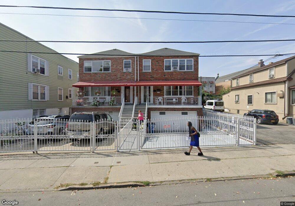
1159 Virginia Ave Bronx, NY 10472
Unionport NeighborhoodEstimated Value: $795,629 - $1,010,000
Studio
--
Bath
2,572
Sq Ft
$350/Sq Ft
Est. Value
About This Home
This home is located at 1159 Virginia Ave, Bronx, NY 10472 and is currently estimated at $899,157, approximately $349 per square foot. 1159 Virginia Ave is a home located in Bronx County with nearby schools including The Dr Emmett W. Bassett School.
Ownership History
Date
Name
Owned For
Owner Type
Purchase Details
Closed on
Jan 29, 1999
Sold by
Pozzuto Vincenzo and Pozzuto Michele
Bought by
Jibodh Maxwell and Jibodh Dharmendra
Current Estimated Value
Home Financials for this Owner
Home Financials are based on the most recent Mortgage that was taken out on this home.
Original Mortgage
$240,250
Interest Rate
7.04%
Mortgage Type
FHA
Create a Home Valuation Report for This Property
The Home Valuation Report is an in-depth analysis detailing your home's value as well as a comparison with similar homes in the area
Home Values in the Area
Average Home Value in this Area
Purchase History
| Date | Buyer | Sale Price | Title Company |
|---|---|---|---|
| Jibodh Maxwell | $255,000 | Record & Return Title Agency |
Source: Public Records
Mortgage History
| Date | Status | Borrower | Loan Amount |
|---|---|---|---|
| Previous Owner | Jibodh Maxwell | $240,250 |
Source: Public Records
Tax History
| Year | Tax Paid | Tax Assessment Tax Assessment Total Assessment is a certain percentage of the fair market value that is determined by local assessors to be the total taxable value of land and additions on the property. | Land | Improvement |
|---|---|---|---|---|
| 2025 | $6,855 | $37,930 | $6,266 | $31,664 |
| 2024 | $6,855 | $37,930 | $6,541 | $31,389 |
| 2023 | $6,986 | $37,644 | $6,766 | $30,878 |
| 2022 | $6,431 | $50,880 | $8,940 | $41,940 |
| 2021 | $6,340 | $46,140 | $8,940 | $37,200 |
| 2020 | $6,031 | $39,900 | $8,940 | $30,960 |
| 2019 | $5,953 | $39,060 | $8,940 | $30,120 |
| 2018 | $5,736 | $31,370 | $8,186 | $23,184 |
| 2017 | $5,387 | $29,595 | $8,926 | $20,669 |
| 2016 | $2,170 | $27,920 | $8,851 | $19,069 |
| 2015 | $1,345 | $26,340 | $9,960 | $16,380 |
| 2014 | $1,345 | $26,340 | $9,960 | $16,380 |
Source: Public Records
Map
Nearby Homes
- 1163 Virginia Ave
- 1886 Gleason Ave
- 1210 White Plains Rd
- 1988B Powell Ave
- 1966 Newbold Ave Unit 108
- 1966 Newbold Ave Unit 1510
- 1966 Newbold Ave Unit 407
- 1966 Newbold Ave Unit 1502
- 1966 Newbold Ave Unit 505
- 1966 Newbold Ave Unit 405
- 1966 Newbold Ave Unit 408
- 1966 Newbold Ave Unit 904
- 1966 Newbold Ave Unit 1109
- 1966 Newbold Ave Unit 308
- 1966 Newbold Ave Unit 303
- 1966 Newbold Ave Unit 709
- 1966 Newbold Ave Unit 104
- 1972 Ellis Ave
- 1262 Leland Ave
- 1805 Gleason Ave
- 1159 Virginia Ave Unit 1
- 1157 Virginia Ave
- 1161 Virginia Ave
- 1155 Virginia Ave
- 1165 Virginia Ave
- 1153 Virginia Ave
- 1144 White Plains Rd
- 1142 White Plains Rd
- 1142 White Plains Rd Unit 4FAM
- 1146 White Plains Rd
- 1140 White Plains Rd
- 1148 White Plains Rd
- 1138 White Plains Rd
- 1923 Powell Ave
- 1151 Virginia Ave
- 1136 White Plains Rd
- 1154 White Plains Rd
- 1178 Virginia Ave
- 1925 Powell Ave
Your Personal Tour Guide
Ask me questions while you tour the home.