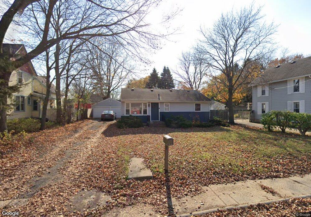
116 Maple St Sugar Grove, IL 60554
Estimated Value: $191,000 - $223,000
2
Beds
--
Bath
816
Sq Ft
$259/Sq Ft
Est. Value
About This Home
This home is located at 116 Maple St, Sugar Grove, IL 60554 and is currently estimated at $211,530, approximately $259 per square foot. 116 Maple St is a home located in Kane County with nearby schools including Kaneland John Shields Elementary School, Harter Middle School, and Kaneland High School.
Ownership History
Date
Name
Owned For
Owner Type
Purchase Details
Closed on
Jun 22, 2022
Sold by
Hardesty David J and Hardesty Erin M
Bought by
David J Hardesty Declaration Of Trust and Erin M Hardes Ty Declaration Of Trust
Current Estimated Value
Purchase Details
Closed on
Jun 1, 2017
Sold by
Rechenmacher Suzanne R and The Suzanne R Rechenmacher Rev
Bought by
Hardesty David J and Hardesty Erin M
Purchase Details
Closed on
Feb 18, 2012
Sold by
Rechenmacher Suzanne R
Bought by
Revocab Rechenmacher Suzanne R and Revocab Suzanne R Rechenmacher
Create a Home Valuation Report for This Property
The Home Valuation Report is an in-depth analysis detailing your home's value as well as a comparison with similar homes in the area
Home Values in the Area
Average Home Value in this Area
Purchase History
| Date | Buyer | Sale Price | Title Company |
|---|---|---|---|
| David J Hardesty Declaration Of Trust | -- | None Listed On Document | |
| Hardesty David J | $55,000 | None Available | |
| Revocab Rechenmacher Suzanne R | -- | None Available |
Source: Public Records
Tax History
| Year | Tax Paid | Tax Assessment Tax Assessment Total Assessment is a certain percentage of the fair market value that is determined by local assessors to be the total taxable value of land and additions on the property. | Land | Improvement |
|---|---|---|---|---|
| 2024 | $4,130 | $56,482 | $24,755 | $31,727 |
| 2023 | $3,950 | $50,940 | $22,326 | $28,614 |
| 2022 | $3,883 | $47,027 | $20,611 | $26,416 |
| 2021 | $3,726 | $44,754 | $19,615 | $25,139 |
| 2020 | $3,665 | $43,800 | $19,197 | $24,603 |
| 2019 | $3,597 | $42,368 | $18,569 | $23,799 |
| 2018 | $4,613 | $51,551 | $13,987 | $37,564 |
| 2017 | $4,458 | $49,232 | $13,358 | $35,874 |
| 2016 | $4,338 | $47,062 | $12,769 | $34,293 |
| 2015 | -- | $43,786 | $11,880 | $31,906 |
| 2014 | -- | $41,869 | $11,360 | $30,509 |
| 2013 | -- | $42,309 | $11,479 | $30,830 |
Source: Public Records
Map
Nearby Homes
- 208 Maple St Unit C
- 222 Meadows Dr
- 273 Bastian Dr Unit 1
- 467 Snow St
- 90 Arbor Ave
- 102 Chelsea Ave
- 47D Rolling Oaks Rd
- 533 Mallard Ln Unit C
- 192 Brompton Ln Unit B
- 182 Brompton Ln Unit A
- 305 Hampton Rd
- 1130 Coneflower St
- 160 Isbell Dr
- 1166 Mariemont Rd
- 249 Coneflower St
- 1156 Mariemont Rd
- 1229 Mariemont Rd
- 1266 Airs Ave
- 1310 Airs Ave
- 306 Atkinson Dr
Your Personal Tour Guide
Ask me questions while you tour the home.