
Seller's Agent in 2025
Betsy Cornell
Corcoran Property Advisors
(617) 571-4668
5 in this area
67 Total Sales

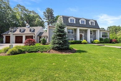


Surrounded by nearly 8 acres of uninterrupted natural beauty, this estate combines timeless design with modern luxury. From its stunning gunite pool and outdoor kitchen to the professionally landscaped grounds, every detail has been thoughtfully curated for elevated living and effortless entertaining. Step inside to a chef’s kitchen that flows seamlessly into a gracious living room, anchored by a cozy gas fireplace. A sunroom, bathed in natural light provides the perfect retreat year-round. The spacious first-floor primary suite is a true sanctuary, featuring a spa-inspired bathroom, a custom walk-in closet, and flexible space ideal for work or relaxation. Upstairs, three generously sized bedrooms and an oversized full bath provide comfort and privacy for family or guests. The walkout lower level offers expansive recreational and entertainment space. This stately home provides countless expansion possibilities and the potential for subdivision.
| Date | Buyer | Sale Price | Title Company |
|---|---|---|---|
| Ann Lombardi 1999 Ret | $1,800,000 | -- | |
| Verrochi Michael J | $100,000 | -- |
| Date | Status | Borrower | Loan Amount |
|---|---|---|---|
| Open | Ann Lombardi 1999 Ret | $1,440,000 |
| Date | Event | Price | List to Sale | Price per Sq Ft |
|---|---|---|---|---|
| 07/31/2025 07/31/25 | Sold | $3,650,000 | -6.4% | $1,015 / Sq Ft |
| 07/02/2025 07/02/25 | Pending | -- | -- | -- |
| 06/04/2025 06/04/25 | For Sale | $3,900,000 | -- | $1,085 / Sq Ft |
| Year | Tax Paid | Tax Assessment Tax Assessment Total Assessment is a certain percentage of the fair market value that is determined by local assessors to be the total taxable value of land and additions on the property. | Land | Improvement |
|---|---|---|---|---|
| 2025 | $6,325 | $591,700 | $523,100 | $68,600 |
| 2024 | $6,420 | $591,700 | $523,100 | $68,600 |
| 2023 | $6,309 | $630,900 | $568,300 | $62,600 |
| 2022 | $5,945 | $514,300 | $452,700 | $61,600 |
| 2021 | $5,660 | $479,700 | $452,700 | $27,000 |
| 2020 | $5,358 | $464,700 | $452,700 | $12,000 |
| 2019 | $5,488 | $464,700 | $452,700 | $12,000 |
| 2018 | $5,470 | $464,700 | $452,700 | $12,000 |
| 2017 | $5,232 | $427,100 | $417,100 | $10,000 |
| 2016 | $5,110 | $409,100 | $399,100 | $10,000 |
| 2015 | $4,909 | $391,800 | $381,800 | $10,000 |
Seller's Agent in 2025
Betsy Cornell
Corcoran Property Advisors
(617) 571-4668
5 in this area
67 Total Sales
Buyer's Agent in 2025
Stacy Howe
Coldwell Banker Realty - Easton
(617) 379-1463
1 in this area
70 Total Sales
Source: MLS Property Information Network (MLS PIN)
MLS Number: 73385081
APN: HING-000205-000000-000003
Disclaimer: Certain information contained herein is derived from information provided by parties other than Homes.com. All information provided is deemed reliable, but is not guaranteed to be accurate and should be independently verified.
![]() The property listing data and information, or the Images, set forth herein were provided to MLS Property Information Network, Inc. from third party sources, including sellers, lessors and public records, and were compiled by MLS Property Information Network, Inc. The property listing data and information, and the Images, are for the personal, non-commercial use of consumers having a good faith interest in purchasing or leasing listed properties of the type displayed to them and may not be used for any purpose other than to identify prospective properties which such consumers may have a good faith interest in purchasing or leasing. MLS Property Information Network, Inc. and its subscribers disclaim any and all representations and warranties as to the accuracy of the property listing data and information, or as to the accuracy of any of the Images, set forth herein.
The property listing data and information, or the Images, set forth herein were provided to MLS Property Information Network, Inc. from third party sources, including sellers, lessors and public records, and were compiled by MLS Property Information Network, Inc. The property listing data and information, and the Images, are for the personal, non-commercial use of consumers having a good faith interest in purchasing or leasing listed properties of the type displayed to them and may not be used for any purpose other than to identify prospective properties which such consumers may have a good faith interest in purchasing or leasing. MLS Property Information Network, Inc. and its subscribers disclaim any and all representations and warranties as to the accuracy of the property listing data and information, or as to the accuracy of any of the Images, set forth herein.
Ask me questions while you tour the home.